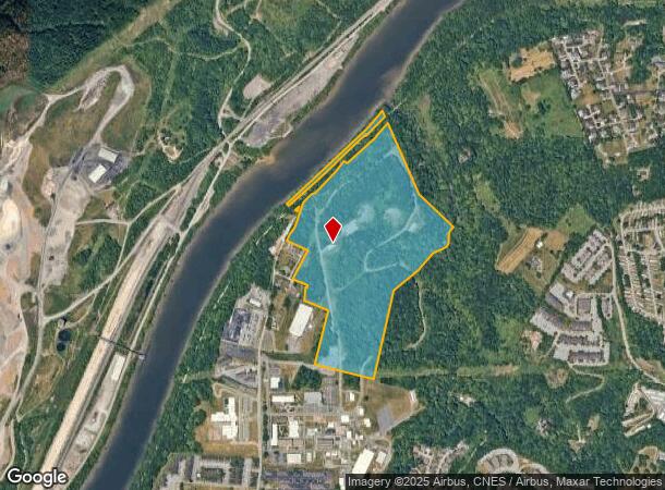
Property Record
Collins Ferry Rd, Morgantown, WV 26505
NEARBY LISTINGS FOR SALE OR LEASE
Property Detail
Collins Ferry Rd
08-1-00050000
61.24 AC FLATTS (FLOOD AREA)
Institutionalvacantland
Monongalia
X
West Virginia
54061C0227F
61.24 AC
0
West Virginia North Area
2025
Other Market Areas
010204
Morgantown, WV
DEMOGRAPHICS near Collins Ferry Rd
1 Mile
3 Mile
5 Mile
2024 Total Population
4,470
40,182
69,719
2029 Population
4,595
41,136
71,552
Pop Growth 2024-2029
+ 2.80%
+ 2.37%
+ 2.63%
Average Age
36
33
34
2024 Total Households
2,048
17,534
30,217
HH Growth 2024-2029
+ 2.78%
+ 2.42%
+ 2.75%
Median Household Inc
$66,096
$42,889
$43,979
Avg Household Size
2.20
1.90
2.00
2024 Avg HH Vehicles
2.00
2.00
2.00
Median Home Value
$284,968
$244,563
$224,602
Median Year Built
1988
1988
1984
Nearby Places
Map Layers
Map Styles
 Street
 Aerial
- Restaurants
- Banks
- Shops
- Fitness
- Groceries
PUBLIC TRANSPORTATION
AIRPORT
North Central West Virginia
DRIVE
WALK
Distance
North Central West Virginia
51 min
37.4 mi
Freight Ports
Port of Baltimore
DRIVE
WALK
Distance
Port of Baltimore
247 min
213.7 mi
SALE & LEASE HISTORY
LISTING DATE
SALE/LEASE

Sep 25, 2016
For Lease
Nearby Properties
Address
Land Use
TOTAL SIZE
Lot Size
Zoning
Address
Land Use
TOTAL SIZE
Lot Size
Zoning
23.86 AC
Address
Land Use
TOTAL SIZE
Lot Size
Zoning
14.68 AC
Address
Land Use
TOTAL SIZE
Lot Size
Zoning
137.68 AC
Address
Land Use
TOTAL SIZE
Lot Size
Zoning
75.75 AC
Address
Land Use
TOTAL SIZE
Lot Size
Zoning
31.67 AC
Address
Land Use
TOTAL SIZE
Lot Size
Zoning
109.09 AC
Address
Land Use
TOTAL SIZE
Lot Size
Zoning
3.07 AC
Address
Land Use
TOTAL SIZE
Lot Size
Zoning
Address
Land Use
TOTAL SIZE
Lot Size
Zoning
19.34 AC
Address
Land Use
TOTAL SIZE
Lot Size
Zoning
45.28 AC
Address
Land Use
TOTAL SIZE
Lot Size
Zoning
89.90 AC
Address
Land Use
TOTAL SIZE
Lot Size
Zoning
15.71 AC
Address
Land Use
TOTAL SIZE
Lot Size
Zoning
30.77 AC
Address
Land Use
TOTAL SIZE
Lot Size
Zoning
53.50 AC
Address
Land Use
TOTAL SIZE
Lot Size
Zoning
Address
Land Use
TOTAL SIZE
Lot Size
Zoning
Address
Land Use
TOTAL SIZE
Lot Size
Zoning
34.21 AC
Address
Land Use
TOTAL SIZE
Lot Size
Zoning
21.61 AC
Address
Land Use
TOTAL SIZE
Lot Size
Zoning
Address
Land Use
TOTAL SIZE
Lot Size
Zoning
Address
Land Use
TOTAL SIZE
Lot Size
Zoning
9.94 AC
Address
Land Use
TOTAL SIZE
Lot Size
Zoning
0.11 AC
Address
Land Use
TOTAL SIZE
Lot Size
Zoning
Address
Land Use
TOTAL SIZE
Lot Size
Zoning
22.11 AC
Address
Land Use
TOTAL SIZE
Lot Size
Zoning
Address
Land Use
TOTAL SIZE
Lot Size
Zoning
18.60 AC
Address
Land Use
TOTAL SIZE
Lot Size
Zoning
3.20 AC
Address
Land Use
TOTAL SIZE
Lot Size
Zoning
0.18 AC
The World's #1 Commercial Real Estate Marketplace
Connect with us
© 2026 CoStar Group
The information above has been obtained from sources believed reliable. While we do not doubt its accuracy we have not verified it and make no guarantee, warranty or representation about it. It is your responsibility to independently confirm its accuracy and completeness. Any projections, opinions, assumptions, or estimates used are for example only and do not represent the current or future performance of the property. The value of this transaction to you depends on tax and other factors which should be evaluated by your tax, financial, and legal advisors. You and your advisors should conduct a careful, independent investigation of the property to determine to your satisfaction the suitability of the property for your needs.