Property Record
Columbia Ave, Chapin, SC 29036

Save to a Folder
{{folder.Name}}
{{folder.ListingIds.length}} Properties
{{folder.ListingIds.length}} Property
Create a New Folder
Property Detail
Columbia Ave
000700-01-003
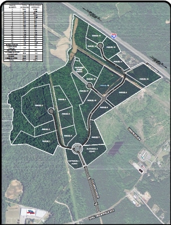
PARCEL A
Commercialacreage
LEXINGTON
GC
South Carolina
B and X Area of moderate flood hazard, usually the area between the limits of the 100-year and 500-year floods.
61.72 AC
2025
Dutch Fork/Irmo
2024
Columbia
021208
Columbia, SC
NEARBY LISTINGS FOR SALE OR LEASE
DEMOGRAPHICS near Columbia Ave
1 mile
3 mile
5 mile
2025 Total Population
597
7,018
23,239
2030 Population
631
7,349
24,249
Pop Growth 2025-2030
+ 5.70%
+ 4.72%
+ 4.35%
Average Age
40
40
41
2025 Total Households
210
2,634
8,672
HH Growth 2025-2030
+ 6.19%
+ 4.90%
+ 4.53%
Median Household Inc
$91,796
$89,107
$106,370
Avg Household Size
2.70
2.60
2.60
2025 Avg HH Vehicles
2.00
2.00
2.00
Median Home Value
$309,701
$298,683
$369,085
Median Year Built
2002
2001
2001
Nearby Places
Map Layers
Map Styles
 Street
 Aerial
Layers
 Traffic
 Biking
Places
Listings with unknown addresses are not visible on the map
- Restaurants
- Banks
- Shops
- Fitness
- Groceries
SALE & LEASE HISTORY
LISTING DATE
SALE/LEASE

Aug 16, 2017
For Sale
Nearby Properties
Address
Land Use
TOTAL SIZE
Lot Size
Zoning
Address
Land Use
TOTAL SIZE
Lot Size
Zoning
10,764 SF
1.84 AC
GC
Address
Land Use
TOTAL SIZE
Lot Size
Zoning
9,124 SF
4.11 AC
RU
Address
Land Use
TOTAL SIZE
Lot Size
Zoning
87.84 AC
Address
Land Use
TOTAL SIZE
Lot Size
Zoning
70.68 AC
RU
Address
Land Use
TOTAL SIZE
Lot Size
Zoning
46,031 SF
12.16 AC
GC
Address
Land Use
TOTAL SIZE
Lot Size
Zoning
45 AC
RU
Address
Land Use
TOTAL SIZE
Lot Size
Zoning
88 AC
RU
Address
Land Use
TOTAL SIZE
Lot Size
Zoning
Address
Land Use
TOTAL SIZE
Lot Size
Zoning
3,165 SF
1.78 AC
RU
Address
Land Use
TOTAL SIZE
Lot Size
Zoning
39 AC
RU
Address
Land Use
TOTAL SIZE
Lot Size
Zoning
67.59 AC
RU
Address
Land Use
TOTAL SIZE
Lot Size
Zoning
3,848 SF
1.13 AC
RU
Address
Land Use
TOTAL SIZE
Lot Size
Zoning
1,248 SF
6.88 AC
RU
Address
Land Use
TOTAL SIZE
Lot Size
Zoning
3,573 SF
4 AC
Address
Land Use
TOTAL SIZE
Lot Size
Zoning
36 AC
RU
Address
Land Use
TOTAL SIZE
Lot Size
Zoning
61,972 SF
7.82 AC
GC
Address
Land Use
TOTAL SIZE
Lot Size
Zoning
2,400 SF
9.76 AC
RU
Address
Land Use
TOTAL SIZE
Lot Size
Zoning
1,814 SF
6 AC
RU
Address
Land Use
TOTAL SIZE
Lot Size
Zoning
8,960 SF
0.75 AC
GC
Address
Land Use
TOTAL SIZE
Lot Size
Zoning
24.64 AC
Address
Land Use
TOTAL SIZE
Lot Size
Zoning
66,432 SF
2.89 AC
GC
Address
Land Use
TOTAL SIZE
Lot Size
Zoning
100,075 SF
12.10 AC
LM
Address
Land Use
TOTAL SIZE
Lot Size
Zoning
1,984 SF
1.36 AC
GC
Address
Land Use
TOTAL SIZE
Lot Size
Zoning
0.83 AC
GC
Address
Land Use
TOTAL SIZE
Lot Size
Zoning
46,244 SF
2.50 AC
INC
Address
Land Use
TOTAL SIZE
Lot Size
Zoning
18.55 AC
RU
Address
Land Use
TOTAL SIZE
Lot Size
Zoning
Address
Land Use
TOTAL SIZE
Lot Size
Zoning
20,595 SF
5.09 AC
GC
Address
Land Use
TOTAL SIZE
Lot Size
Zoning
43,119 SF
5.99 AC
GC
Address
Land Use
TOTAL SIZE
Lot Size
Zoning
32,737 SF
4.76 AC
ID
The World's #1 Commercial Real Estate Marketplace
Connect with us
© 2026 CoStar Group
The information above has been obtained from sources believed reliable. While we do not doubt its accuracy we have not verified it and make no guarantee, warranty or representation about it. It is your responsibility to independently confirm its accuracy and completeness. Any projections, opinions, assumptions, or estimates used are for example only and do not represent the current or future performance of the property. The value of this transaction to you depends on tax and other factors which should be evaluated by your tax, financial, and legal advisors. You and your advisors should conduct a careful, independent investigation of the property to determine to your satisfaction the suitability of the property for your needs.