Property Record
Columbia Tpke, Rensselaer, NY 12144
NEARBY LISTINGS FOR SALE OR LEASE
Property Detail
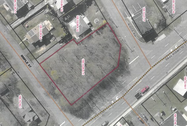
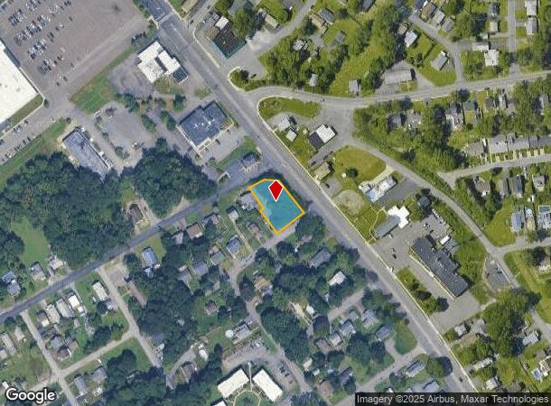
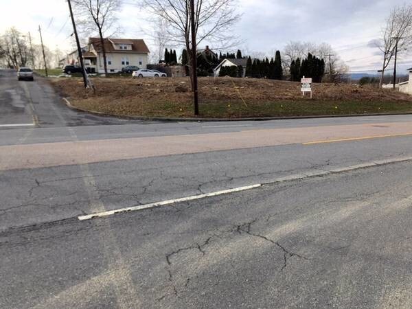
Columbia Tpke
Albany-Schenectady-Troy, NY
NYS ACQ 240/2478 02/20/01
2400-155.13-20-4.11
Rensselaer
Commercialacreage
New York
ARE
4.011
36083C0351D
0.40 AC
2025
Outer Rensselaer County
2024
Albany/Schenectady/Troy
052406
DEMOGRAPHICS near Columbia Tpke
1 Mile
3 Mile
5 Mile
2024 Total Population
5,590
47,027
130,496
2029 Population
5,517
46,537
129,041
Pop Growth 2024-2029
(1.31%)
(1.04%)
(1.11%)
Average Age
42
39
39
2024 Total Households
2,408
21,444
56,801
HH Growth 2024-2029
(1.45%)
(0.97%)
(1.14%)
Median Household Inc
$92,463
$62,504
$65,463
Avg Household Size
2.30
2.10
2.10
2024 Avg HH Vehicles
2.00
1.00
1.00
Median Home Value
$201,120
$202,534
$239,621
Median Year Built
1962
1956
1957
Nearby Places
- Restaurants
- Banks
- Shops
- Fitness
- Groceries
PUBLIC TRANSPORTATION
AIRPORT
Albany International
DRIVE
WALK
Distance
Albany International
25 min
16.7 mi
Freight Ports
Albany, NY Port
DRIVE
WALK
Distance
Albany, NY Port
1 min
1.4 mi
SALE & LEASE HISTORY
LISTING DATE
SALE/LEASE

Sep 17, 2019
For Sale
Aug 14, 2018
For Sale
Nearby Properties
Address
Land Use
TOTAL SIZE
Lot Size
Zoning
Address
Land Use
TOTAL SIZE
Lot Size
Zoning
901,573 SF
38 AC
CO
Address
Land Use
TOTAL SIZE
Lot Size
Zoning
11,372 SF
30 AC
CO
Address
Land Use
TOTAL SIZE
Lot Size
Zoning
33.88 AC
I2
Address
Land Use
TOTAL SIZE
Lot Size
Zoning
567,019 SF
1.42 AC
CO
Address
Land Use
TOTAL SIZE
Lot Size
Zoning
1.42 AC
C3
Address
Land Use
TOTAL SIZE
Lot Size
Zoning
83.50 AC
Address
Land Use
TOTAL SIZE
Lot Size
Zoning
368,685 SF
3.10 AC
CO
Address
Land Use
TOTAL SIZE
Lot Size
Zoning
358,360 SF
10.10 AC
CO
Address
Land Use
TOTAL SIZE
Lot Size
Zoning
541,564 SF
7.40 AC
C3
Address
Land Use
TOTAL SIZE
Lot Size
Zoning
207.50 AC
CM
Address
Land Use
TOTAL SIZE
Lot Size
Zoning
802,560 SF
5.70 AC
R4
Address
Land Use
TOTAL SIZE
Lot Size
Zoning
177,030 SF
0.06 AC
C3
Address
Land Use
TOTAL SIZE
Lot Size
Zoning
889,560 SF
0.50 AC
CO
Address
Land Use
TOTAL SIZE
Lot Size
Zoning
166,812 SF
0.78 AC
CO
Address
Land Use
TOTAL SIZE
Lot Size
Zoning
296,914 SF
68.73 AC
PDD
Address
Land Use
TOTAL SIZE
Lot Size
Zoning
428,555 SF
1.20 AC
C3
Address
Land Use
TOTAL SIZE
Lot Size
Zoning
179,713 SF
126.43 AC
OC
Address
Land Use
TOTAL SIZE
Lot Size
Zoning
104,077 SF
6.64 AC
B-2
Address
Land Use
TOTAL SIZE
Lot Size
Zoning
556,800 SF
0.39 AC
CM
Address
Land Use
TOTAL SIZE
Lot Size
Zoning
316,634 SF
27.82 AC
OI
Address
Land Use
TOTAL SIZE
Lot Size
Zoning
161,972 SF
26.62 AC
OI
Address
Land Use
TOTAL SIZE
Lot Size
Zoning
171,096 SF
18.04 AC
B-2
Address
Land Use
TOTAL SIZE
Lot Size
Zoning
470,768 SF
2.20 AC
C3
Address
Land Use
TOTAL SIZE
Lot Size
Zoning
129,415 SF
19.90 AC
C2
Address
Land Use
TOTAL SIZE
Lot Size
Zoning
194,018 SF
73.71 AC
R-B
Address
Land Use
TOTAL SIZE
Lot Size
Zoning
87,000 SF
0.28 AC
C3
Address
Land Use
TOTAL SIZE
Lot Size
Zoning
2.25 AC
Address
Land Use
TOTAL SIZE
Lot Size
Zoning
170,387 SF
0.54 AC
C3
Address
Land Use
TOTAL SIZE
Lot Size
Zoning
88,040 SF
1.80 AC
C3
Address
Land Use
TOTAL SIZE
Lot Size
Zoning
5,776 SF
90.90 AC
M1
The World's #1 Commercial Real Estate Marketplace
Connect with us
© 2025 CoStar Group
The information above has been obtained from sources believed reliable. While we do not doubt its accuracy we have not verified it and make no guarantee, warranty or representation about it. It is your responsibility to independently confirm its accuracy and completeness. Any projections, opinions, assumptions, or estimates used are for example only and do not represent the current or future performance of the property. The value of this transaction to you depends on tax and other factors which should be evaluated by your tax, financial, and legal advisors. You and your advisors should conduct a careful, independent investigation of the property to determine to your satisfaction the suitability of the property for your needs.