Property Record
Concorde Dr, Dayton, OH 45414


Property Detail
Concorde Dr
R72717413-0015
85017 CONCORDE SUBDIVISION -A ABA 100% NC 2018-2032 TAXABLE 2033
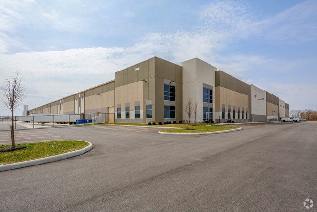
Warehouse
MONTGOMERY
B and X Area of moderate flood hazard, usually the area between the limits of the 100-year and 500-year floods.
Ohio
2024
31.03 AC
2025
North Dayton
080500
Cincinnati/Dayton
509,060 SF
Dayton, OH
NEARBY LISTINGS FOR SALE OR LEASE
-
-
View all Dayton listings for lease on LoopNet.com
DEMOGRAPHICS near Concorde Dr
1 mile
3 mile
5 mile
2025 Total Population
47
15,402
64,371
2030 Population
46
15,119
63,556
Pop Growth 2025-2030
(2.13%)
(1.84%)
(1.27%)
Average Age
40
42
43
2025 Total Households
18
6,658
27,379
HH Growth 2025-2030
0.00%
(1.83%)
(1.28%)
Median Household Inc
$118,749
$87,474
$73,995
Avg Household Size
2.40
2.30
2.30
2025 Avg HH Vehicles
2.00
2.00
2.00
Median Home Value
$289,999
$242,997
$204,621
Median Year Built
1972
1969
1970
Nearby Places
Map Layers
Map Styles
 Street
 Aerial
Transit
 Traffic
 Biking
Places
Listings with unknown addresses are not visible on the map
- Restaurants
- Banks
- Shops
- Fitness
- Groceries
PUBLIC TRANSPORTATION
AIRPORT
James M Cox Dayton International
Drive
Walk
Distance
James M Cox Dayton International
9 min
2.4 mi
SALE & LEASE HISTORY
LISTING DATE
SALE/LEASE

Oct 01, 2018
For Lease
Nov 07, 2016
For Lease
Mar 09, 2018
For Lease
Dec 03, 2018
For Lease
Nearby Properties
Address
Land Use
TOTAL SIZE
Lot Size
Zoning
Address
Land Use
TOTAL SIZE
Lot Size
Zoning
2,810,636 SF
79.21 AC
Address
Land Use
TOTAL SIZE
Lot Size
Zoning
1,841,033 SF
129.70 AC
Address
Land Use
TOTAL SIZE
Lot Size
Zoning
562,815 SF
41.46 AC
Address
Land Use
TOTAL SIZE
Lot Size
Zoning
551,408 SF
71 AC
Address
Land Use
TOTAL SIZE
Lot Size
Zoning
1,059,902 SF
56.13 AC
Address
Land Use
TOTAL SIZE
Lot Size
Zoning
678,154 SF
858.39 AC
Address
Land Use
TOTAL SIZE
Lot Size
Zoning
634,247 SF
86.18 AC
Address
Land Use
TOTAL SIZE
Lot Size
Zoning
834,238 SF
42.05 AC
Address
Land Use
TOTAL SIZE
Lot Size
Zoning
704,988 SF
49.15 AC
Address
Land Use
TOTAL SIZE
Lot Size
Zoning
664,824 SF
1,128.84 AC
Address
Land Use
TOTAL SIZE
Lot Size
Zoning
37.86 AC
Address
Land Use
TOTAL SIZE
Lot Size
Zoning
597,314 SF
38.27 AC
Address
Land Use
TOTAL SIZE
Lot Size
Zoning
527,904 SF
75.77 AC
Address
Land Use
TOTAL SIZE
Lot Size
Zoning
730,000 SF
56.40 AC
Address
Land Use
TOTAL SIZE
Lot Size
Zoning
522,340 SF
36.59 AC
Address
Land Use
TOTAL SIZE
Lot Size
Zoning
45,980 SF
6.05 AC
Address
Land Use
TOTAL SIZE
Lot Size
Zoning
433,792 SF
34.46 AC
Address
Land Use
TOTAL SIZE
Lot Size
Zoning
730,000 SF
56.40 AC
Address
Land Use
TOTAL SIZE
Lot Size
Zoning
12,660 SF
20.22 AC
Address
Land Use
TOTAL SIZE
Lot Size
Zoning
Address
Land Use
TOTAL SIZE
Lot Size
Zoning
92,192 SF
41.46 AC
Address
Land Use
TOTAL SIZE
Lot Size
Zoning
172,753 SF
23.76 AC
Address
Land Use
TOTAL SIZE
Lot Size
Zoning
200,716 SF
32.06 AC
Address
Land Use
TOTAL SIZE
Lot Size
Zoning
143,980 SF
35.40 AC
Address
Land Use
TOTAL SIZE
Lot Size
Zoning
222,799 SF
13.74 AC
Address
Land Use
TOTAL SIZE
Lot Size
Zoning
0.45 AC
Address
Land Use
TOTAL SIZE
Lot Size
Zoning
92,440 SF
3.01 AC
Address
Land Use
TOTAL SIZE
Lot Size
Zoning
76,156 SF
97.13 AC
Address
Land Use
TOTAL SIZE
Lot Size
Zoning
Address
Land Use
TOTAL SIZE
Lot Size
Zoning
165,018 SF
19.77 AC
The World's #1 Commercial Real Estate Marketplace
Connect with us
© 2026 CoStar Group
The information above has been obtained from sources believed reliable. While we do not doubt its accuracy we have not verified it and make no guarantee, warranty or representation about it. It is your responsibility to independently confirm its accuracy and completeness. Any projections, opinions, assumptions, or estimates used are for example only and do not represent the current or future performance of the property. The value of this transaction to you depends on tax and other factors which should be evaluated by your tax, financial, and legal advisors. You and your advisors should conduct a careful, independent investigation of the property to determine to your satisfaction the suitability of the property for your needs.