Property Record
Conners Dr, Bowman, SC 29018
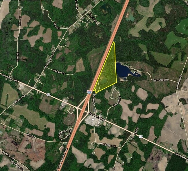

Property Detail
Conners Dr
007-00-00-191
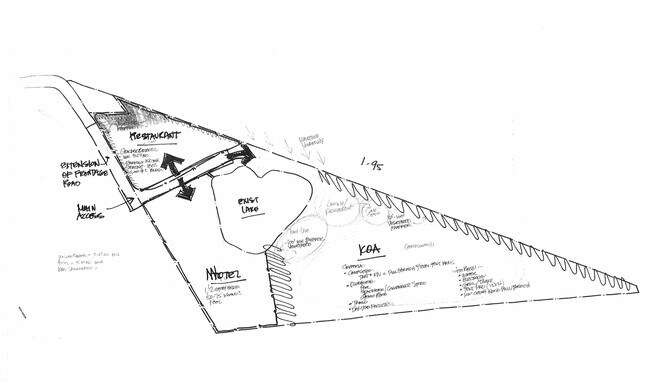
CONNERS DR COMMERCIAL
Commercialnec
DORCHESTER
CG_DC
South Carolina
AE The base floodplain where base flood elevations are provided. AE Zones are now used on new format FIRMs instead of A1-A30 Zones.
43.29 AC
2024
Dorchester County
2025
Charleston/N Charleston
010500
Charleston-North Charleston, SC
NEARBY LISTINGS FOR SALE OR LEASE
DEMOGRAPHICS near Conners Dr
1 mile
3 mile
5 mile
2025 Total Population
261
1,282
3,334
2030 Population
289
1,408
3,638
Pop Growth 2025-2030
+ 10.73%
+ 9.83%
+ 9.12%
Average Age
46
45
45
2025 Total Households
116
567
1,454
HH Growth 2025-2030
+ 11.21%
+ 10.23%
+ 9.35%
Median Household Inc
$69,374
$69,030
$66,649
Avg Household Size
2.20
2.20
2.30
2025 Avg HH Vehicles
2.00
2.00
2.00
Median Home Value
$75,780
$81,292
$103,093
Median Year Built
1983
1983
1983
Nearby Places
Map Layers
Map Styles
 Street
 Aerial
Layers
 Traffic
 Biking
Places
Listings with unknown addresses are not visible on the map
- Restaurants
- Banks
- Shops
- Fitness
- Groceries
SALE & LEASE HISTORY
LISTING DATE
SALE/LEASE

Dec 12, 2022
For Sale
Nearby Properties
Address
Land Use
TOTAL SIZE
Lot Size
Zoning
Address
Land Use
TOTAL SIZE
Lot Size
Zoning
14,388 SF
11.03 AC
CG_DC
Address
Land Use
TOTAL SIZE
Lot Size
Zoning
7,182 SF
10.56 AC
CG_DC
Address
Land Use
TOTAL SIZE
Lot Size
Zoning
158.30 AC
AR_DC
Address
Land Use
TOTAL SIZE
Lot Size
Zoning
15,315 SF
2.51 AC
CG_DC
Address
Land Use
TOTAL SIZE
Lot Size
Zoning
16,560 SF
10.50 AC
AR_DC
Address
Land Use
TOTAL SIZE
Lot Size
Zoning
335.60 AC
AR_DC
Address
Land Use
TOTAL SIZE
Lot Size
Zoning
10,336 SF
32.10 AC
CG_DC
Address
Land Use
TOTAL SIZE
Lot Size
Zoning
13,080 SF
1.80 AC
CG_DC
Address
Land Use
TOTAL SIZE
Lot Size
Zoning
5,175 SF
0.91 AC
CG_DC
Address
Land Use
TOTAL SIZE
Lot Size
Zoning
27.05 AC
CG_DC
Address
Land Use
TOTAL SIZE
Lot Size
Zoning
50.47 AC
I_DC
Address
Land Use
TOTAL SIZE
Lot Size
Zoning
234.44 AC
AR_DC
Address
Land Use
TOTAL SIZE
Lot Size
Zoning
228.50 AC
AR_DC
Address
Land Use
TOTAL SIZE
Lot Size
Zoning
226.59 AC
AR_DC
Address
Land Use
TOTAL SIZE
Lot Size
Zoning
65.61 AC
CG_DC
Address
Land Use
TOTAL SIZE
Lot Size
Zoning
193.48 AC
AR_DC
Address
Land Use
TOTAL SIZE
Lot Size
Zoning
33.82 AC
CLI_DC
Address
Land Use
TOTAL SIZE
Lot Size
Zoning
190.79 AC
AR_DC
Address
Land Use
TOTAL SIZE
Lot Size
Zoning
18.83 AC
CG_DC
Address
Land Use
TOTAL SIZE
Lot Size
Zoning
31.79 AC
CG_DC
Address
Land Use
TOTAL SIZE
Lot Size
Zoning
175.90 AC
AR_DC
Address
Land Use
TOTAL SIZE
Lot Size
Zoning
7,248 SF
0.70 AC
AR_DC
Address
Land Use
TOTAL SIZE
Lot Size
Zoning
164.95 AC
AR_DC
Address
Land Use
TOTAL SIZE
Lot Size
Zoning
28.48 AC
CLI_DC
Address
Land Use
TOTAL SIZE
Lot Size
Zoning
48.69 AC
AR_DC
Address
Land Use
TOTAL SIZE
Lot Size
Zoning
151.19 AC
AR_DC
Address
Land Use
TOTAL SIZE
Lot Size
Zoning
33.82 AC
CG_DC
Address
Land Use
TOTAL SIZE
Lot Size
Zoning
98.25 AC
AR_DC
Address
Land Use
TOTAL SIZE
Lot Size
Zoning
136.45 AC
AR_DC
The World's #1 Commercial Real Estate Marketplace
Connect with us
© 2026 CoStar Group
The information above has been obtained from sources believed reliable. While we do not doubt its accuracy we have not verified it and make no guarantee, warranty or representation about it. It is your responsibility to independently confirm its accuracy and completeness. Any projections, opinions, assumptions, or estimates used are for example only and do not represent the current or future performance of the property. The value of this transaction to you depends on tax and other factors which should be evaluated by your tax, financial, and legal advisors. You and your advisors should conduct a careful, independent investigation of the property to determine to your satisfaction the suitability of the property for your needs.