Property Record
Contra Costa Blvd, Pleasant Hill, CA 94523

NEARBY LISTINGS FOR SALE OR LEASE
-
-
View all Pleasant Hill listings for sale on LoopNet.com
Property Detail
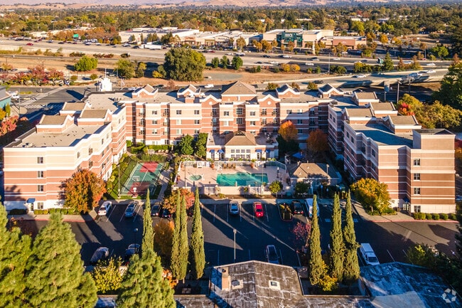
Contra Costa Blvd
Oakland-Fremont-Berkeley, CA
Walnut Crk Acres 01
149-110-086-1
WALNUT CREEK ACRES POR LOTS 13-18
Motel
Contra Costa
X
California
06013C0283F
13-18
2025
0.87 AC
2025
Oakland Northeast/Concord
324002
East Bay/Oakland
102,506 SF
DEMOGRAPHICS near Contra Costa Blvd
1 mile
3 mile
5 mile
2024 Total Population
24,223
145,655
274,201
2029 Population
24,102
144,986
272,439
Pop Growth 2024-2029
(0.50%)
(0.46%)
(0.64%)
Average Age
40
41
42
2024 Total Households
10,038
58,872
108,513
HH Growth 2024-2029
(0.40%)
(0.37%)
(0.59%)
Median Household Inc
$108,392
$119,278
$121,652
Avg Household Size
2.30
2.40
2.50
2024 Avg HH Vehicles
2.00
2.00
2.00
Median Home Value
$776,655
$882,170
$872,895
Median Year Built
1973
1973
1972
Nearby Places
Map Layers
Map Styles
 Street
 Aerial
Transit
 Traffic
 Biking
Places
Listings with unknown addresses are not visible on the map
- Restaurants
- Banks
- Shops
- Fitness
- Groceries
PUBLIC TRANSPORTATION
COMMUTER RAIL
Martinez (California Zephyr - Capitol Corridor Joint Powers Authority, Capitol Corridor - Capitol Corridor Joint Powers Authority, Coast Starlight - Capitol Corridor Joint Powers Authority, San Joaquins - Capitol Corridor Joint Powers Authority)
Drive
Walk
Distance
Martinez (California Zephyr - Capitol Corridor Joint Powers Authority, Capitol Corridor - Capitol Corridor Joint Powers Authority, Coast Starlight - Capitol Corridor Joint Powers Authority, San Joaquins - Capitol Corridor Joint Powers Authority)
13 min
9.0 mi
AIRPORT
Metro Oakland International
Drive
Walk
Distance
Metro Oakland International
36 min
26.2 mi
San Francisco International
Drive
Walk
Distance
San Francisco International
54 min
38.2 mi
Freight Ports
Port of Oakland
Drive
Walk
Distance
Port of Oakland
26 min
19.0 mi
Nearby Properties
Address
Land Use
TOTAL SIZE
Lot Size
Zoning
Address
Land Use
TOTAL SIZE
Lot Size
Zoning
Address
Land Use
TOTAL SIZE
Lot Size
Zoning
Address
Land Use
TOTAL SIZE
Lot Size
Zoning
428,476 SF
3.56 AC
Address
Land Use
TOTAL SIZE
Lot Size
Zoning
489,813 SF
38.82 AC
Address
Land Use
TOTAL SIZE
Lot Size
Zoning
34,226 SF
30 AC
Address
Land Use
TOTAL SIZE
Lot Size
Zoning
155,176 SF
3.34 AC
Address
Land Use
TOTAL SIZE
Lot Size
Zoning
295,561 SF
3.80 AC
Address
Land Use
TOTAL SIZE
Lot Size
Zoning
337,980 SF
5.08 AC
Address
Land Use
TOTAL SIZE
Lot Size
Zoning
254,940 SF
1.61 AC
P1
Address
Land Use
TOTAL SIZE
Lot Size
Zoning
245,822 SF
2.37 AC
R15
Address
Land Use
TOTAL SIZE
Lot Size
Zoning
31,614 SF
24.46 AC
Address
Land Use
TOTAL SIZE
Lot Size
Zoning
174,951 SF
1.82 AC
Address
Land Use
TOTAL SIZE
Lot Size
Zoning
264,873 SF
2.19 AC
P1
Address
Land Use
TOTAL SIZE
Lot Size
Zoning
203,454 SF
2.33 AC
Address
Land Use
TOTAL SIZE
Lot Size
Zoning
5.52 AC
P1
Address
Land Use
TOTAL SIZE
Lot Size
Zoning
235,495 SF
2.51 AC
P1
Address
Land Use
TOTAL SIZE
Lot Size
Zoning
250,032 SF
7.95 AC
P1
Address
Land Use
TOTAL SIZE
Lot Size
Zoning
153,137 SF
1.22 AC
Address
Land Use
TOTAL SIZE
Lot Size
Zoning
393,680 SF
2.29 AC
Address
Land Use
TOTAL SIZE
Lot Size
Zoning
234,624 SF
6.63 AC
Address
Land Use
TOTAL SIZE
Lot Size
Zoning
157,352 SF
0.98 AC
Address
Land Use
TOTAL SIZE
Lot Size
Zoning
249,628 SF
3.64 AC
P1
Address
Land Use
TOTAL SIZE
Lot Size
Zoning
112,000 SF
18.40 AC
Address
Land Use
TOTAL SIZE
Lot Size
Zoning
118,596 SF
1.20 AC
Address
Land Use
TOTAL SIZE
Lot Size
Zoning
168,606 SF
2.42 AC
Address
Land Use
TOTAL SIZE
Lot Size
Zoning
152,581 SF
1.39 AC
Address
Land Use
TOTAL SIZE
Lot Size
Zoning
192,387 SF
17.42 AC
M17
Address
Land Use
TOTAL SIZE
Lot Size
Zoning
301,628 SF
1.68 AC
Address
Land Use
TOTAL SIZE
Lot Size
Zoning
130,000 SF
2.62 AC
Address
Land Use
TOTAL SIZE
Lot Size
Zoning
12,864 SF
5.62 AC
The World's #1 Commercial Real Estate Marketplace
Connect with us
© 2026 CoStar Group
The information above has been obtained from sources believed reliable. While we do not doubt its accuracy we have not verified it and make no guarantee, warranty or representation about it. It is your responsibility to independently confirm its accuracy and completeness. Any projections, opinions, assumptions, or estimates used are for example only and do not represent the current or future performance of the property. The value of this transaction to you depends on tax and other factors which should be evaluated by your tax, financial, and legal advisors. You and your advisors should conduct a careful, independent investigation of the property to determine to your satisfaction the suitability of the property for your needs.