Property Record
Cook Dr, Athens, OH 45701

Property Detail
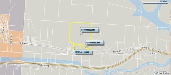
Cook Dr
Athens, OH
13-05-00 SEC 34 9.760A
E03-03401039-00
ATHENS
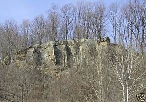
Residentialacreage
Ohio
B and X Area of moderate flood hazard, usually the area between the limits of the 100-year and 500-year floods.
9.76 AC
2024
Ohio South Area
2024
Other Market Areas
973901
NEARBY LISTINGS FOR SALE OR LEASE
-
-
View all Athens listings for sale on LoopNet.com
DEMOGRAPHICS near Cook Dr
1 mile
3 mile
5 mile
2025 Total Population
331
17,197
29,753
2030 Population
326
17,277
29,861
Pop Growth 2025-2030
(1.51%)
+ 0.47%
+ 0.36%
Average Age
42
28
31
2025 Total Households
151
4,924
9,795
HH Growth 2025-2030
(0.66%)
+ 0.43%
+ 0.12%
Median Household Inc
$74,062
$36,130
$42,380
Avg Household Size
2.20
2.20
2.20
2025 Avg HH Vehicles
2.00
2.00
2.00
Median Home Value
$287,499
$263,287
$250,740
Median Year Built
1960
1967
1977
Nearby Places
Map Layers
Map Styles
 Street
 Aerial
Transit
 Traffic
 Biking
Places
Listings with unknown addresses are not visible on the map
- Restaurants
- Banks
- Shops
- Fitness
- Groceries
Nearby Properties
Address
Land Use
TOTAL SIZE
Lot Size
Zoning
Address
Land Use
TOTAL SIZE
Lot Size
Zoning
270,480 SF
100.28 AC
Address
Land Use
TOTAL SIZE
Lot Size
Zoning
0.30 AC
Address
Land Use
TOTAL SIZE
Lot Size
Zoning
380,042 SF
11.62 AC
Address
Land Use
TOTAL SIZE
Lot Size
Zoning
329,244 SF
Address
Land Use
TOTAL SIZE
Lot Size
Zoning
10.06 AC
Address
Land Use
TOTAL SIZE
Lot Size
Zoning
191,801 SF
3 AC
Address
Land Use
TOTAL SIZE
Lot Size
Zoning
43,469 SF
4.78 AC
Address
Land Use
TOTAL SIZE
Lot Size
Zoning
64,218 SF
8.65 AC
Address
Land Use
TOTAL SIZE
Lot Size
Zoning
12 AC
Address
Land Use
TOTAL SIZE
Lot Size
Zoning
150,578 SF
2.59 AC
Address
Land Use
TOTAL SIZE
Lot Size
Zoning
169,832 SF
0.49 AC
Address
Land Use
TOTAL SIZE
Lot Size
Zoning
117,143 SF
0.93 AC
Address
Land Use
TOTAL SIZE
Lot Size
Zoning
114,857 SF
0.48 AC
Address
Land Use
TOTAL SIZE
Lot Size
Zoning
61,456 SF
1.09 AC
Address
Land Use
TOTAL SIZE
Lot Size
Zoning
173,461 SF
12 AC
Address
Land Use
TOTAL SIZE
Lot Size
Zoning
113,828 SF
0.71 AC
Address
Land Use
TOTAL SIZE
Lot Size
Zoning
116,023 SF
0.85 AC
Address
Land Use
TOTAL SIZE
Lot Size
Zoning
99,964 SF
1.04 AC
Address
Land Use
TOTAL SIZE
Lot Size
Zoning
171,885 SF
15.19 AC
Address
Land Use
TOTAL SIZE
Lot Size
Zoning
1,485 SF
23.99 AC
Address
Land Use
TOTAL SIZE
Lot Size
Zoning
183,602 SF
0.04 AC
Address
Land Use
TOTAL SIZE
Lot Size
Zoning
7.25 AC
Address
Land Use
TOTAL SIZE
Lot Size
Zoning
127,035 SF
0.55 AC
Address
Land Use
TOTAL SIZE
Lot Size
Zoning
128,098 SF
0.27 AC
Address
Land Use
TOTAL SIZE
Lot Size
Zoning
96,231 SF
1.70 AC
Address
Land Use
TOTAL SIZE
Lot Size
Zoning
146,909 SF
2.68 AC
Address
Land Use
TOTAL SIZE
Lot Size
Zoning
70,283 SF
0.45 AC
Address
Land Use
TOTAL SIZE
Lot Size
Zoning
258,656 SF
72.80 AC
Address
Land Use
TOTAL SIZE
Lot Size
Zoning
77,001 SF
6.82 AC
Address
Land Use
TOTAL SIZE
Lot Size
Zoning
124,617 SF
2.10 AC
The World's #1 Commercial Real Estate Marketplace
Connect with us
© 2026 CoStar Group
The information above has been obtained from sources believed reliable. While we do not doubt its accuracy we have not verified it and make no guarantee, warranty or representation about it. It is your responsibility to independently confirm its accuracy and completeness. Any projections, opinions, assumptions, or estimates used are for example only and do not represent the current or future performance of the property. The value of this transaction to you depends on tax and other factors which should be evaluated by your tax, financial, and legal advisors. You and your advisors should conduct a careful, independent investigation of the property to determine to your satisfaction the suitability of the property for your needs.