Property Record
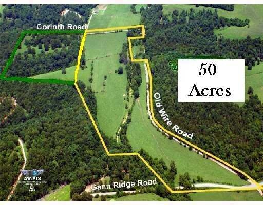
Corinth Rd, Pea Ridge, AR 72751
Save to a Folder
{{folder.Name}}
{{folder.ListingIds.length}} Properties
{{folder.ListingIds.length}} Property
Create a New Folder
Property Detail
Corinth Rd
Fayetteville-Springdale-Rogers, AR
THE SE/4 OF THE SE/4 OF SECTION 14, A PART OF THE SW/4 OF THE SW/4 OF SECTION 13, PART OF THE NE/4 OF THE NE/4 OF SECTION 23 AND PART OF THE NW/4 OF THE NW/4 AND PART OF THE SW/4 OF THE NW/4 OF SECTION 24, ALL IN TOWNSHIP 21 NORTH, RANGE 29 WEST, BEN
18-05451-001
BENTON
Residentialacreage
Arkansas
B and X Area of moderate flood hazard, usually the area between the limits of the 100-year and 500-year floods.
1.04 AC
2025
Outlying Benton County
2025
Fayetteville/Springdale/Rogers
021404
NEARBY LISTINGS FOR SALE OR LEASE
-
-
View all Pea Ridge listings for sale on LoopNet.com
DEMOGRAPHICS near Corinth Rd
1 mile
3 mile
5 mile
2025 Total Population
266
1,326
4,780
2030 Population
298
1,468
5,311
Pop Growth 2025-2030
+ 12.03%
+ 10.71%
+ 11.11%
Average Age
41
41
41
2025 Total Households
97
486
1,751
HH Growth 2025-2030
+ 12.37%
+ 10.70%
+ 11.19%
Median Household Inc
$69,374
$67,321
$70,201
Avg Household Size
2.70
2.70
2.70
2025 Avg HH Vehicles
3.00
3.00
3.00
Median Home Value
$357,142
$330,172
$327,987
Median Year Built
2000
1997
1994
Nearby Places
Map Layers
Map Styles
 Street
 Aerial
Layers
 Traffic
 Biking
Places
Listings with unknown addresses are not visible on the map
- Restaurants
- Banks
- Shops
- Fitness
- Groceries
PUBLIC TRANSPORTATION
AIRPORT
Northwest Arkansas Ntl
Drive
Walk
Distance
Northwest Arkansas Ntl
60 min
28.4 mi
Freight Ports
Tulsa Port of Inola
Drive
Walk
Distance
Tulsa Port of Inola
147 min
113.6 mi
Nearby Properties
Address
Land Use
TOTAL SIZE
Lot Size
Zoning
Address
Land Use
TOTAL SIZE
Lot Size
Zoning
5,440 SF
1.74 AC
Address
Land Use
TOTAL SIZE
Lot Size
Zoning
6,000 SF
3.75 AC
Address
Land Use
TOTAL SIZE
Lot Size
Zoning
5,000 SF
3 AC
Address
Land Use
TOTAL SIZE
Lot Size
Zoning
1,300 SF
3 AC
Address
Land Use
TOTAL SIZE
Lot Size
Zoning
1,452 SF
2.53 AC
Address
Land Use
TOTAL SIZE
Lot Size
Zoning
9,504 SF
2.08 AC
Address
Land Use
TOTAL SIZE
Lot Size
Zoning
8.29 AC
Address
Land Use
TOTAL SIZE
Lot Size
Zoning
7.79 AC
Address
Land Use
TOTAL SIZE
Lot Size
Zoning
7.65 AC
Address
Land Use
TOTAL SIZE
Lot Size
Zoning
4.90 AC
Address
Land Use
TOTAL SIZE
Lot Size
Zoning
4.89 AC
Address
Land Use
TOTAL SIZE
Lot Size
Zoning
9.99 AC
Address
Land Use
TOTAL SIZE
Lot Size
Zoning
2.91 AC
Address
Land Use
TOTAL SIZE
Lot Size
Zoning
Address
Land Use
TOTAL SIZE
Lot Size
Zoning
2.88 AC
Address
Land Use
TOTAL SIZE
Lot Size
Zoning
7.92 AC
Address
Land Use
TOTAL SIZE
Lot Size
Zoning
4,224 SF
1.03 AC
Address
Land Use
TOTAL SIZE
Lot Size
Zoning
7.30 AC
Address
Land Use
TOTAL SIZE
Lot Size
Zoning
Address
Land Use
TOTAL SIZE
Lot Size
Zoning
Address
Land Use
TOTAL SIZE
Lot Size
Zoning
2,400 SF
2.11 AC
Address
Land Use
TOTAL SIZE
Lot Size
Zoning
Address
Land Use
TOTAL SIZE
Lot Size
Zoning
1.98 AC
Address
Land Use
TOTAL SIZE
Lot Size
Zoning
5.03 AC
Address
Land Use
TOTAL SIZE
Lot Size
Zoning
5.03 AC
Address
Land Use
TOTAL SIZE
Lot Size
Zoning
5.03 AC
Address
Land Use
TOTAL SIZE
Lot Size
Zoning
Address
Land Use
TOTAL SIZE
Lot Size
Zoning
Address
Land Use
TOTAL SIZE
Lot Size
Zoning
Address
Land Use
TOTAL SIZE
Lot Size
Zoning
1.76 AC
The World's #1 Commercial Real Estate Marketplace
Connect with us
© 2026 CoStar Group
The information above has been obtained from sources believed reliable. While we do not doubt its accuracy we have not verified it and make no guarantee, warranty or representation about it. It is your responsibility to independently confirm its accuracy and completeness. Any projections, opinions, assumptions, or estimates used are for example only and do not represent the current or future performance of the property. The value of this transaction to you depends on tax and other factors which should be evaluated by your tax, financial, and legal advisors. You and your advisors should conduct a careful, independent investigation of the property to determine to your satisfaction the suitability of the property for your needs.