Property Record
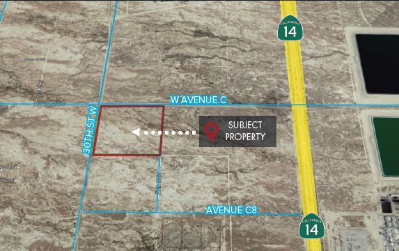
Corner Avenue C 30 Stw, Lancaster, CA 93536
NEARBY LISTINGS FOR SALE OR LEASE
Property Detail
Corner Avenue C 30 Stw
Los Angeles-Long Beach-Glendale, CA
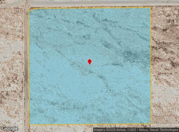
NW 1/4 OF NW 1/4 (EX OF ST) OF SEC 17 T 8N R 12W
3115-011-001
Los Angeles
Desertorbarrenland
California
A
17
06029C4025E
39.22 AC
2024
Antelope Valley
2025
Los Angeles
901214
DEMOGRAPHICS near Corner Avenue C 30 Stw
1 Mile
3 Mile
5 Mile
2024 Total Population
3
763
9,686
2029 Population
3
760
9,728
Pop Growth 2024-2029
0.00%
(0.39%)
+ 0.43%
Average Age
0
52
36
2024 Total Households
2
359
3,356
HH Growth 2024-2029
0.00%
(0.56%)
+ 0.24%
Median Household Inc
$0
$34,999
$68,893
Avg Household Size
1.50
2.10
2.80
2024 Avg HH Vehicles
1.00
1.00
2.00
Median Home Value
$50,000
$60,546
$289,560
Median Year Built
1984
1983
1992
Nearby Places
Map Layers
Map Styles
 Street
 Aerial
- Restaurants
- Banks
- Shops
- Fitness
- Groceries
PUBLIC TRANSPORTATION
COMMUTER RAIL
Lancaster (Antelope Valley Line - Southern California Regional Rail Authority (Metrolink))
DRIVE
WALK
Distance
Lancaster (Antelope Valley Line - Southern California Regional Rail Authority (Metrolink))
14 min
9.2 mi
Freight Ports
Port of Long Beach
DRIVE
WALK
Distance
Port of Long Beach
119 min
100.6 mi
SALE & LEASE HISTORY
LISTING DATE
SALE/LEASE

May 25, 2021
For Sale
Mar 11, 2020
For Sale
Nearby Properties
Address
Land Use
TOTAL SIZE
Lot Size
Zoning
Address
Land Use
TOTAL SIZE
Lot Size
Zoning
11,603 SF
475.12 AC
LCA2
Address
Land Use
TOTAL SIZE
Lot Size
Zoning
58.68 AC
LCD22*
Address
Land Use
TOTAL SIZE
Lot Size
Zoning
57.24 AC
LCD22*
Address
Land Use
TOTAL SIZE
Lot Size
Zoning
81.54 AC
LCD22*
Address
Land Use
TOTAL SIZE
Lot Size
Zoning
32.84 AC
LCD22*
Address
Land Use
TOTAL SIZE
Lot Size
Zoning
2.13 AC
C-2 PD
Address
Land Use
TOTAL SIZE
Lot Size
Zoning
37.01 AC
LRA12*
Address
Land Use
TOTAL SIZE
Lot Size
Zoning
60 SF
29.74 AC
LCA22*
Address
Land Use
TOTAL SIZE
Lot Size
Zoning
39.96 AC
LCD22*
Address
Land Use
TOTAL SIZE
Lot Size
Zoning
59.44 AC
LCA2
Address
Land Use
TOTAL SIZE
Lot Size
Zoning
1 SF
55.38 AC
LCA2
Address
Land Use
TOTAL SIZE
Lot Size
Zoning
4,540 SF
4.76 AC
LRA12*
Address
Land Use
TOTAL SIZE
Lot Size
Zoning
79.05 AC
LCD22*
Address
Land Use
TOTAL SIZE
Lot Size
Zoning
38.95 AC
LCD22*
Address
Land Use
TOTAL SIZE
Lot Size
Zoning
154.58 AC
LCD22*
Address
Land Use
TOTAL SIZE
Lot Size
Zoning
76.61 AC
LCD22*
Address
Land Use
TOTAL SIZE
Lot Size
Zoning
39.24 AC
LCD22*
Address
Land Use
TOTAL SIZE
Lot Size
Zoning
17.97 AC
LRA12*
Address
Land Use
TOTAL SIZE
Lot Size
Zoning
377.35 AC
LCD22*
Address
Land Use
TOTAL SIZE
Lot Size
Zoning
19.59 AC
LCD22*
Address
Land Use
TOTAL SIZE
Lot Size
Zoning
40.79 AC
LCD22*
Address
Land Use
TOTAL SIZE
Lot Size
Zoning
818 SF
35.89 AC
LCD22*
Address
Land Use
TOTAL SIZE
Lot Size
Zoning
19.61 AC
LCD22*
Address
Land Use
TOTAL SIZE
Lot Size
Zoning
5.10 AC
LCD22*
Address
Land Use
TOTAL SIZE
Lot Size
Zoning
24.96 AC
LCA22*
Address
Land Use
TOTAL SIZE
Lot Size
Zoning
19.99 AC
LRA12*
Address
Land Use
TOTAL SIZE
Lot Size
Zoning
79.49 AC
LCD22*
Address
Land Use
TOTAL SIZE
Lot Size
Zoning
5.10 AC
LCD22*
Address
Land Use
TOTAL SIZE
Lot Size
Zoning
736 SF
47.27 AC
M-2 PD FPS
The World's #1 Commercial Real Estate Marketplace
Connect with us
© 2026 CoStar Group
The information above has been obtained from sources believed reliable. While we do not doubt its accuracy we have not verified it and make no guarantee, warranty or representation about it. It is your responsibility to independently confirm its accuracy and completeness. Any projections, opinions, assumptions, or estimates used are for example only and do not represent the current or future performance of the property. The value of this transaction to you depends on tax and other factors which should be evaluated by your tax, financial, and legal advisors. You and your advisors should conduct a careful, independent investigation of the property to determine to your satisfaction the suitability of the property for your needs.