Property Record
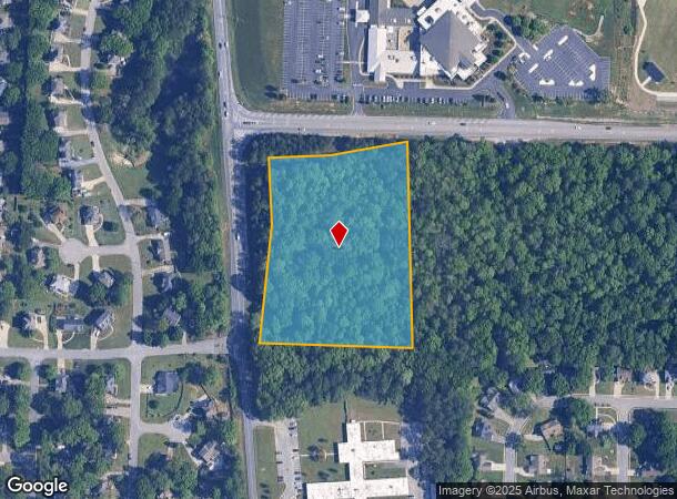
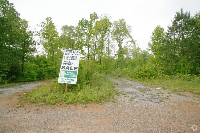
Corner Of Hwy 95 And Industrial Rd Across Hwy, Alabaster, AL 35007

NEARBY LISTINGS FOR SALE OR LEASE
Property Detail
Corner Of Hwy 95 And Industrial Rd Across Hwy
13-7-35-2-001-001-000
COM SE COR NE1/4 NW1/4 W814.38 TO POB W455.81 TO ELY ROW CO RD 95 N ALG SD ROW TO S ROW LN CO RD 65 E450(S) ALG SD ROW S TO POB
Vacantlandnec
Shelby
X
Alabama
01117C0214E
5.58 AC
2024
I-65 Corr/S Shelby County
2024
Birmingham
030306
Birmingham-Hoover, AL
DEMOGRAPHICS near Corner Of Hwy 95 And Industrial Rd Across Hwy
1 Mile
3 Mile
5 Mile
2024 Total Population
7,285
39,041
66,567
2029 Population
7,839
42,120
72,023
Pop Growth 2024-2029
+ 7.60%
+ 7.89%
+ 8.20%
Average Age
40
39
39
2024 Total Households
2,490
14,196
24,129
HH Growth 2024-2029
+ 7.83%
+ 8.06%
+ 8.36%
Median Household Inc
$86,239
$84,827
$85,947
Avg Household Size
2.70
2.70
2.70
2024 Avg HH Vehicles
2.00
2.00
2.00
Median Home Value
$206,933
$223,050
$238,791
Median Year Built
1987
1993
1995
Nearby Places
Map Layers
Map Styles
 Street
 Aerial
- Restaurants
- Banks
- Shops
- Fitness
- Groceries
PUBLIC TRANSPORTATION
AIRPORT
Birmingham-Shuttlesworth International
DRIVE
WALK
Distance
Birmingham-Shuttlesworth International
38 min
27.4 mi
Freight Ports
Port of Mobile
DRIVE
WALK
Distance
Port of Mobile
258 min
236.6 mi
SALE & LEASE HISTORY
LISTING DATE
SALE/LEASE

Sep 24, 2016
For Sale
Jan 16, 2020
For Sale
Nearby Properties
Address
Land Use
TOTAL SIZE
Lot Size
Zoning
Address
Land Use
TOTAL SIZE
Lot Size
Zoning
228,107 SF
12 AC
Address
Land Use
TOTAL SIZE
Lot Size
Zoning
225,092 SF
53 AC
Address
Land Use
TOTAL SIZE
Lot Size
Zoning
2,100 SF
6.50 AC
Address
Land Use
TOTAL SIZE
Lot Size
Zoning
5,574 SF
14.87 AC
Address
Land Use
TOTAL SIZE
Lot Size
Zoning
2,891 SF
18.10 AC
Address
Land Use
TOTAL SIZE
Lot Size
Zoning
3,872 SF
20.35 AC
Address
Land Use
TOTAL SIZE
Lot Size
Zoning
9,444 SF
21.79 AC
Address
Land Use
TOTAL SIZE
Lot Size
Zoning
10,500 SF
21 AC
Address
Land Use
TOTAL SIZE
Lot Size
Zoning
1,763 SF
21.99 AC
Address
Land Use
TOTAL SIZE
Lot Size
Zoning
11,192 SF
26.78 AC
Address
Land Use
TOTAL SIZE
Lot Size
Zoning
226,790 SF
40 AC
Address
Land Use
TOTAL SIZE
Lot Size
Zoning
118,303 SF
22.89 AC
Address
Land Use
TOTAL SIZE
Lot Size
Zoning
219,975 SF
14.90 AC
Address
Land Use
TOTAL SIZE
Lot Size
Zoning
161,753 SF
25 AC
Address
Land Use
TOTAL SIZE
Lot Size
Zoning
268,750 SF
9.93 AC
Address
Land Use
TOTAL SIZE
Lot Size
Zoning
62,398 SF
11.51 AC
Address
Land Use
TOTAL SIZE
Lot Size
Zoning
84,355 SF
15.65 AC
Address
Land Use
TOTAL SIZE
Lot Size
Zoning
43,419 SF
7.81 AC
Address
Land Use
TOTAL SIZE
Lot Size
Zoning
126,897 SF
9.43 AC
Address
Land Use
TOTAL SIZE
Lot Size
Zoning
46,031 SF
9.86 AC
Address
Land Use
TOTAL SIZE
Lot Size
Zoning
6,864 SF
6.11 AC
Address
Land Use
TOTAL SIZE
Lot Size
Zoning
30,158 SF
8.35 AC
Address
Land Use
TOTAL SIZE
Lot Size
Zoning
137,068 SF
9.08 AC
Address
Land Use
TOTAL SIZE
Lot Size
Zoning
54,297 SF
41 AC
Address
Land Use
TOTAL SIZE
Lot Size
Zoning
3,414 SF
7.03 AC
Address
Land Use
TOTAL SIZE
Lot Size
Zoning
77,365 SF
24.97 AC
Address
Land Use
TOTAL SIZE
Lot Size
Zoning
43,903 SF
10.21 AC
Address
Land Use
TOTAL SIZE
Lot Size
Zoning
Address
Land Use
TOTAL SIZE
Lot Size
Zoning
94,901 SF
10.78 AC
The World's #1 Commercial Real Estate Marketplace
Connect with us
© 2025 CoStar Group
The information above has been obtained from sources believed reliable. While we do not doubt its accuracy we have not verified it and make no guarantee, warranty or representation about it. It is your responsibility to independently confirm its accuracy and completeness. Any projections, opinions, assumptions, or estimates used are for example only and do not represent the current or future performance of the property. The value of this transaction to you depends on tax and other factors which should be evaluated by your tax, financial, and legal advisors. You and your advisors should conduct a careful, independent investigation of the property to determine to your satisfaction the suitability of the property for your needs.