Property Record
Willis Rd, Sharpsburg, GA 30277
NEARBY LISTINGS FOR SALE OR LEASE
Property Detail
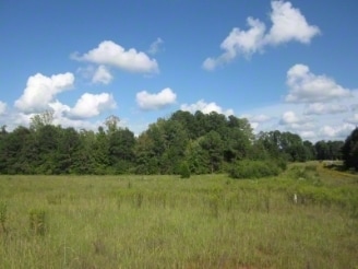
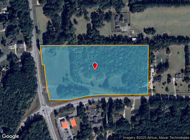
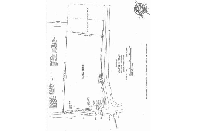
Willis Rd
Atlanta-Sandy Springs-Roswell, GA
12.25AC LL 86 LD 1
135-1086-039
Coweta
Commercialnec
Georgia
X
86
13077C0256D
12.25 AC
2025
Fayette/Coweta County
2025
Atlanta
170405
DEMOGRAPHICS near Willis Rd
1 Mile
3 Mile
5 Mile
2024 Total Population
1,813
16,189
48,621
2029 Population
2,003
18,126
53,765
Pop Growth 2024-2029
+ 10.48%
+ 11.96%
+ 10.58%
Average Age
41
40
41
2024 Total Households
670
5,740
17,845
HH Growth 2024-2029
+ 10.60%
+ 12.06%
+ 10.64%
Median Household Inc
$89,039
$96,485
$99,145
Avg Household Size
2.70
2.80
2.70
2024 Avg HH Vehicles
2.00
2.00
2.00
Median Home Value
$262,663
$262,549
$291,529
Median Year Built
1994
1995
1997
Nearby Places
- Restaurants
- Banks
- Shops
- Fitness
- Groceries
PUBLIC TRANSPORTATION
AIRPORT
Hartsfield - Jackson Atlanta International
DRIVE
WALK
Distance
Hartsfield - Jackson Atlanta International
40 min
30.5 mi
Freight Ports
Georgia Ports - Savannah
DRIVE
WALK
Distance
Georgia Ports - Savannah
285 min
244.7 mi
SALE & LEASE HISTORY
LISTING DATE
SALE/LEASE

Dec 13, 2017
For Sale
Nearby Properties
Address
Land Use
TOTAL SIZE
Lot Size
Zoning
Address
Land Use
TOTAL SIZE
Lot Size
Zoning
166,866 SF
85.16 AC
R1
Address
Land Use
TOTAL SIZE
Lot Size
Zoning
112,934 SF
108.27 AC
R1
Address
Land Use
TOTAL SIZE
Lot Size
Zoning
71,888 SF
23.48 AC
R1
Address
Land Use
TOTAL SIZE
Lot Size
Zoning
47,598 SF
4.29 AC
C
Address
Land Use
TOTAL SIZE
Lot Size
Zoning
91,629 SF
23.51 AC
R1
Address
Land Use
TOTAL SIZE
Lot Size
Zoning
784 SF
517.26 AC
RFA
Address
Land Use
TOTAL SIZE
Lot Size
Zoning
25,600 SF
131.86 AC
R1
Address
Land Use
TOTAL SIZE
Lot Size
Zoning
89,260 SF
10.26 AC
001
Address
Land Use
TOTAL SIZE
Lot Size
Zoning
31,794 SF
2.65 AC
R1
Address
Land Use
TOTAL SIZE
Lot Size
Zoning
98,838 SF
8.18 AC
R1
Address
Land Use
TOTAL SIZE
Lot Size
Zoning
59,753 SF
8.77 AC
R1
Address
Land Use
TOTAL SIZE
Lot Size
Zoning
28,683 SF
33.64 AC
R1
Address
Land Use
TOTAL SIZE
Lot Size
Zoning
6,375 SF
1.62 AC
R1
Address
Land Use
TOTAL SIZE
Lot Size
Zoning
31,546 SF
31.32 AC
001
Address
Land Use
TOTAL SIZE
Lot Size
Zoning
24,300 SF
24.76 AC
R1
Address
Land Use
TOTAL SIZE
Lot Size
Zoning
18,136 SF
7.89 AC
R1
Address
Land Use
TOTAL SIZE
Lot Size
Zoning
24,421 SF
22.74 AC
001
Address
Land Use
TOTAL SIZE
Lot Size
Zoning
35,100 SF
5.26 AC
M
Address
Land Use
TOTAL SIZE
Lot Size
Zoning
23,822 SF
10.09 AC
R1
Address
Land Use
TOTAL SIZE
Lot Size
Zoning
14,198 SF
14.68 AC
R1
Address
Land Use
TOTAL SIZE
Lot Size
Zoning
6,273 SF
241.53 AC
R1
Address
Land Use
TOTAL SIZE
Lot Size
Zoning
11,050 SF
9.90 AC
R1
Address
Land Use
TOTAL SIZE
Lot Size
Zoning
11,875 SF
33.91 AC
R1
Address
Land Use
TOTAL SIZE
Lot Size
Zoning
8,641 SF
3.31 AC
M
Address
Land Use
TOTAL SIZE
Lot Size
Zoning
7,168 SF
2 AC
R1
Address
Land Use
TOTAL SIZE
Lot Size
Zoning
12,780 SF
2.38 AC
001
Address
Land Use
TOTAL SIZE
Lot Size
Zoning
19,400 SF
5 AC
M
Address
Land Use
TOTAL SIZE
Lot Size
Zoning
800 SF
7.07 AC
R1
Address
Land Use
TOTAL SIZE
Lot Size
Zoning
26,898 SF
2.42 AC
M
Address
Land Use
TOTAL SIZE
Lot Size
Zoning
7,000 SF
1.61 AC
R1
The World's #1 Commercial Real Estate Marketplace
Connect with us
© 2025 CoStar Group
The information above has been obtained from sources believed reliable. While we do not doubt its accuracy we have not verified it and make no guarantee, warranty or representation about it. It is your responsibility to independently confirm its accuracy and completeness. Any projections, opinions, assumptions, or estimates used are for example only and do not represent the current or future performance of the property. The value of this transaction to you depends on tax and other factors which should be evaluated by your tax, financial, and legal advisors. You and your advisors should conduct a careful, independent investigation of the property to determine to your satisfaction the suitability of the property for your needs.