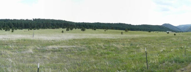
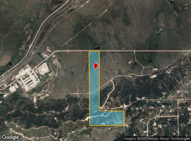
Property Record
County Line Rd, Monument, CO 80132
NEARBY LISTINGS FOR SALE OR LEASE
Property Detail
County Line Rd
Colorado Springs, CO
Monument Add
71040-00-002
W2NE4 SEC 04-11-67 EX THAT PORT DES AS FOLS: COM AT NW COR OF NE4 SEC 4, TH S 88<2338 E 399.42 FT FOR POB, S 00<5722 W 2323.35 FT, S 88<2250 E 934.39 FT TO A PT ON E LN OF W2NE4 OF SEC 4, N 00<5834 E 800.31 FT TO SE COR OF NW4NE4 SEC 4, TH CONT N 00<
Timberlandforesttreesagricultural
El Paso
X
Colorado
08041C0257G
34.29 AC
2024
Northwest
2025
Colorado Springs
007401
DEMOGRAPHICS near County Line Rd
1 mile
3 mile
5 mile
2024 Total Population
931
10,147
23,790
2029 Population
932
10,539
24,853
Pop Growth 2024-2029
+ 0.11%
+ 3.86%
+ 4.47%
Average Age
44
43
42
2024 Total Households
370
3,714
8,531
HH Growth 2024-2029
+ 0.54%
+ 3.98%
+ 4.62%
Median Household Inc
$119,594
$125,792
$129,334
Avg Household Size
2.50
2.70
2.80
2024 Avg HH Vehicles
3.00
3.00
3.00
Median Home Value
$596,561
$633,890
$646,222
Median Year Built
1983
1990
1994
Nearby Places
Map Layers
Map Styles
 Street
 Aerial
Transit
 Traffic
 Biking
Places
Listings with unknown addresses are not visible on the map
- Restaurants
- Banks
- Shops
- Fitness
- Groceries
PUBLIC TRANSPORTATION
AIRPORT
City of Colorado Springs Municipal
Drive
Walk
Distance
City of Colorado Springs Municipal
42 min
30.2 mi
Freight Ports
Tulsa Port Of Catoosa
Drive
Walk
Distance
Tulsa Port Of Catoosa
751 min
705.2 mi
Nearby Properties
Address
Land Use
TOTAL SIZE
Lot Size
Zoning
Address
Land Use
TOTAL SIZE
Lot Size
Zoning
57,619 SF
3.26 AC
SFD-2
Address
Land Use
TOTAL SIZE
Lot Size
Zoning
600 SF
40 AC
A-5
Address
Land Use
TOTAL SIZE
Lot Size
Zoning
21,695 SF
1.17 AC
BP
Address
Land Use
TOTAL SIZE
Lot Size
Zoning
38,142 SF
7.28 AC
A-5
Address
Land Use
TOTAL SIZE
Lot Size
Zoning
25,600 SF
10.11 AC
CC
Address
Land Use
TOTAL SIZE
Lot Size
Zoning
16,608 SF
1.14 AC
P
Address
Land Use
TOTAL SIZE
Lot Size
Zoning
12,167 SF
1.40 AC
DB
Address
Land Use
TOTAL SIZE
Lot Size
Zoning
31,037 SF
9.80 AC
PUD
Address
Land Use
TOTAL SIZE
Lot Size
Zoning
1,047.40 AC
OS
Address
Land Use
TOTAL SIZE
Lot Size
Zoning
9,631 SF
15.85 AC
PUD
Address
Land Use
TOTAL SIZE
Lot Size
Zoning
12.30 AC
CC
Address
Land Use
TOTAL SIZE
Lot Size
Zoning
87,656 SF
4.30 AC
I-2
Address
Land Use
TOTAL SIZE
Lot Size
Zoning
21.63 AC
RR-5
Address
Land Use
TOTAL SIZE
Lot Size
Zoning
7,924 SF
0.59 AC
CC
Address
Land Use
TOTAL SIZE
Lot Size
Zoning
7,040 SF
0.22 AC
Address
Land Use
TOTAL SIZE
Lot Size
Zoning
53,688 SF
14.12 AC
PUD
Address
Land Use
TOTAL SIZE
Lot Size
Zoning
11,616 SF
4.81 AC
RR-5
Address
Land Use
TOTAL SIZE
Lot Size
Zoning
29,253 SF
21.12 AC
Address
Land Use
TOTAL SIZE
Lot Size
Zoning
10 AC
CC
Address
Land Use
TOTAL SIZE
Lot Size
Zoning
7,797 SF
1.28 AC
RA
Address
Land Use
TOTAL SIZE
Lot Size
Zoning
474.82 AC
OS
Address
Land Use
TOTAL SIZE
Lot Size
Zoning
5,873 SF
0.34 AC
P
Address
Land Use
TOTAL SIZE
Lot Size
Zoning
7,955 SF
0.70 AC
C-2
Address
Land Use
TOTAL SIZE
Lot Size
Zoning
53,981 SF
4 AC
CC
Address
Land Use
TOTAL SIZE
Lot Size
Zoning
5,277 SF
2 AC
R3
Address
Land Use
TOTAL SIZE
Lot Size
Zoning
55,183 SF
5.50 AC
CC
Address
Land Use
TOTAL SIZE
Lot Size
Zoning
7,637 SF
0.23 AC
DB
Address
Land Use
TOTAL SIZE
Lot Size
Zoning
21,338 SF
1.97 AC
PUD
Address
Land Use
TOTAL SIZE
Lot Size
Zoning
36,389 SF
1.92 AC
C2
Address
Land Use
TOTAL SIZE
Lot Size
Zoning
4,040 SF
2.32 AC
RR-5
The World's #1 Commercial Real Estate Marketplace
Connect with us
© 2026 CoStar Group
The information above has been obtained from sources believed reliable. While we do not doubt its accuracy we have not verified it and make no guarantee, warranty or representation about it. It is your responsibility to independently confirm its accuracy and completeness. Any projections, opinions, assumptions, or estimates used are for example only and do not represent the current or future performance of the property. The value of this transaction to you depends on tax and other factors which should be evaluated by your tax, financial, and legal advisors. You and your advisors should conduct a careful, independent investigation of the property to determine to your satisfaction the suitability of the property for your needs.