Property Record
County Rd 559, Poplar Bluff, MO 63901
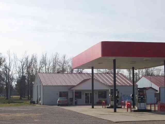

Property Detail
County Rd 559
Poplar Bluff, MO
PT LOT 2 SW1/4 : BEG 291' E SW COR: NE 2 34.5: N E 1026.4: S 941: W 941: W 750' & SE 50' ABAND RR A DJ ON N: EX 9.18 AC TO ST
109-09-09-30-0-000-000-042-000
BUTLER
Conveniencestore
Missouri
A Areas with a 1% annual chance of flooding and a 26% chance of flooding over the life of a 30-year mortgage.
2
2025
1.76 AC
2025
Missouri South Area
950302
Other Market Areas
3,240 SF
NEARBY LISTINGS FOR SALE OR LEASE
-
-
View all Poplar Bluff listings for sale on LoopNet.com
DEMOGRAPHICS near County Rd 559
1 mile
3 mile
5 mile
2025 Total Population
318
7,125
19,415
2030 Population
319
7,111
19,242
Pop Growth 2025-2030
+ 0.31%
(0.20%)
(0.89%)
Average Age
42
40
40
2025 Total Households
148
2,978
7,981
HH Growth 2025-2030
+ 0.68%
(0.17%)
(0.91%)
Median Household Inc
$32,083
$45,355
$43,700
Avg Household Size
2.00
2.30
2.30
2025 Avg HH Vehicles
1.00
1.00
2.00
Median Home Value
$150,000
$122,353
$132,223
Median Year Built
1967
1971
1975
Nearby Places
Map Layers
Map Styles
 Street
 Aerial
Layers
 Traffic
 Biking
Places
Listings with unknown addresses are not visible on the map
- Restaurants
- Banks
- Shops
- Fitness
- Groceries
PUBLIC TRANSPORTATION
COMMUTER RAIL
Poplar Bluff Amtrak Station (Texas Eagle - Amtrak)
Drive
Walk
Distance
Poplar Bluff Amtrak Station (Texas Eagle - Amtrak)
6 min
3.2 mi
Freight Ports
Tulsa Port of Inola
Drive
Walk
Distance
Tulsa Port of Inola
411 min
360.8 mi
Nearby Properties
Address
Land Use
TOTAL SIZE
Lot Size
Zoning
Address
Land Use
TOTAL SIZE
Lot Size
Zoning
34,740 SF
6.87 AC
Address
Land Use
TOTAL SIZE
Lot Size
Zoning
71,641 SF
0.98 AC
Address
Land Use
TOTAL SIZE
Lot Size
Zoning
Address
Land Use
TOTAL SIZE
Lot Size
Zoning
Address
Land Use
TOTAL SIZE
Lot Size
Zoning
Address
Land Use
TOTAL SIZE
Lot Size
Zoning
36,228 SF
1.01 AC
Address
Land Use
TOTAL SIZE
Lot Size
Zoning
61,025 SF
2.72 AC
Address
Land Use
TOTAL SIZE
Lot Size
Zoning
30,576 SF
8.82 AC
Address
Land Use
TOTAL SIZE
Lot Size
Zoning
18,329 SF
2.63 AC
Address
Land Use
TOTAL SIZE
Lot Size
Zoning
23,447 SF
18.81 AC
Address
Land Use
TOTAL SIZE
Lot Size
Zoning
7,261 SF
2.10 AC
Address
Land Use
TOTAL SIZE
Lot Size
Zoning
16,874 SF
0.33 AC
Address
Land Use
TOTAL SIZE
Lot Size
Zoning
11,327 SF
2.02 AC
Address
Land Use
TOTAL SIZE
Lot Size
Zoning
16,777 SF
0.25 AC
Address
Land Use
TOTAL SIZE
Lot Size
Zoning
10,000 SF
3.58 AC
Address
Land Use
TOTAL SIZE
Lot Size
Zoning
31,197 SF
1.08 AC
Address
Land Use
TOTAL SIZE
Lot Size
Zoning
9,918 SF
0.33 AC
Address
Land Use
TOTAL SIZE
Lot Size
Zoning
0.45 AC
Address
Land Use
TOTAL SIZE
Lot Size
Zoning
3,592 SF
2.22 AC
Address
Land Use
TOTAL SIZE
Lot Size
Zoning
16,664 SF
1.67 AC
Address
Land Use
TOTAL SIZE
Lot Size
Zoning
16,270 SF
2 AC
Address
Land Use
TOTAL SIZE
Lot Size
Zoning
Address
Land Use
TOTAL SIZE
Lot Size
Zoning
6,643 SF
19 AC
Address
Land Use
TOTAL SIZE
Lot Size
Zoning
56.65 AC
Address
Land Use
TOTAL SIZE
Lot Size
Zoning
6,896 SF
0.22 AC
Address
Land Use
TOTAL SIZE
Lot Size
Zoning
Address
Land Use
TOTAL SIZE
Lot Size
Zoning
13,602 SF
1.77 AC
Address
Land Use
TOTAL SIZE
Lot Size
Zoning
12,518 SF
Address
Land Use
TOTAL SIZE
Lot Size
Zoning
4,652 SF
1.75 AC
Address
Land Use
TOTAL SIZE
Lot Size
Zoning
12,144 SF
0.98 AC
The World's #1 Commercial Real Estate Marketplace
Connect with us
© 2026 CoStar Group
The information above has been obtained from sources believed reliable. While we do not doubt its accuracy we have not verified it and make no guarantee, warranty or representation about it. It is your responsibility to independently confirm its accuracy and completeness. Any projections, opinions, assumptions, or estimates used are for example only and do not represent the current or future performance of the property. The value of this transaction to you depends on tax and other factors which should be evaluated by your tax, financial, and legal advisors. You and your advisors should conduct a careful, independent investigation of the property to determine to your satisfaction the suitability of the property for your needs.