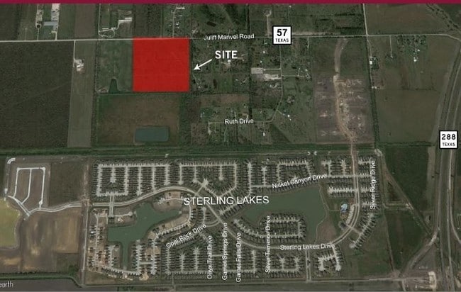
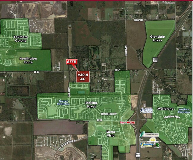
Property Record
County Road 57, Rosharon, TX 77583
NEARBY LISTINGS FOR SALE OR LEASE
Property Detail
County Road 57
Houston-Pasadena-The Woodlands, TX
Colony Estates Phase I (A0289 H T & B)
2868-1001-009
COLONY ESTATES PHASE I (A0289 H T & B) BLK 1 LOT 4 ACRES 1.0006
Agriculturalland
Brazoria
X
Texas
48039C0105K
4
2024
29.08 AC
2025
South Hwy 35
661902
Houston
DEMOGRAPHICS near County Road 57
1 Mile
3 Mile
5 Mile
2024 Total Population
5,704
23,696
67,109
2029 Population
6,624
28,494
79,375
Pop Growth 2024-2029
+ 16.13%
+ 20.25%
+ 18.28%
Average Age
33
33
34
2024 Total Households
1,741
7,430
19,993
HH Growth 2024-2029
+ 16.26%
+ 20.57%
+ 18.86%
Median Household Inc
$86,469
$77,392
$91,914
Avg Household Size
3.30
3.20
3.20
2024 Avg HH Vehicles
2.00
2.00
2.00
Median Home Value
$282,279
$252,767
$279,764
Median Year Built
2011
2010
2010
Nearby Places
Map Layers
Map Styles
 Street
 Aerial
- Restaurants
- Banks
- Shops
- Fitness
- Groceries
PUBLIC TRANSPORTATION
AIRPORT
William P Hobby
DRIVE
WALK
Distance
William P Hobby
40 min
23.5 mi
Freight Ports
Port of Houston
DRIVE
WALK
Distance
Port of Houston
45 min
30.3 mi
SALE & LEASE HISTORY
LISTING DATE
SALE/LEASE

Mar 28, 2017
For Sale
Nearby Properties
Address
Land Use
TOTAL SIZE
Lot Size
Zoning
Address
Land Use
TOTAL SIZE
Lot Size
Zoning
Address
Land Use
TOTAL SIZE
Lot Size
Zoning
170.62 AC
Address
Land Use
TOTAL SIZE
Lot Size
Zoning
Address
Land Use
TOTAL SIZE
Lot Size
Zoning
199,508 SF
18.04 AC
Address
Land Use
TOTAL SIZE
Lot Size
Zoning
121,138 SF
11.52 AC
Address
Land Use
TOTAL SIZE
Lot Size
Zoning
65,403 SF
14.65 AC
Address
Land Use
TOTAL SIZE
Lot Size
Zoning
127,500 SF
7.60 AC
Address
Land Use
TOTAL SIZE
Lot Size
Zoning
70,000 SF
64.91 AC
Address
Land Use
TOTAL SIZE
Lot Size
Zoning
2,000 SF
24.85 AC
Address
Land Use
TOTAL SIZE
Lot Size
Zoning
28,633 SF
9.36 AC
Address
Land Use
TOTAL SIZE
Lot Size
Zoning
14,968 SF
1.81 AC
Address
Land Use
TOTAL SIZE
Lot Size
Zoning
214,827 SF
15.70 AC
0033
Address
Land Use
TOTAL SIZE
Lot Size
Zoning
47,500 SF
Address
Land Use
TOTAL SIZE
Lot Size
Zoning
16,298 SF
2.87 AC
Address
Land Use
TOTAL SIZE
Lot Size
Zoning
75,548 SF
12.30 AC
Address
Land Use
TOTAL SIZE
Lot Size
Zoning
17,250 SF
2.39 AC
Address
Land Use
TOTAL SIZE
Lot Size
Zoning
114,723 SF
20.13 AC
0007
Address
Land Use
TOTAL SIZE
Lot Size
Zoning
91.43 AC
SQ
Address
Land Use
TOTAL SIZE
Lot Size
Zoning
29,625 SF
2.01 AC
Address
Land Use
TOTAL SIZE
Lot Size
Zoning
7,298 SF
7.97 AC
Address
Land Use
TOTAL SIZE
Lot Size
Zoning
1.86 AC
Address
Land Use
TOTAL SIZE
Lot Size
Zoning
14,726 SF
1.80 AC
Address
Land Use
TOTAL SIZE
Lot Size
Zoning
41,540 SF
5.71 AC
Address
Land Use
TOTAL SIZE
Lot Size
Zoning
17,700 SF
2.59 AC
Address
Land Use
TOTAL SIZE
Lot Size
Zoning
4,743 SF
1.35 AC
Address
Land Use
TOTAL SIZE
Lot Size
Zoning
1.56 AC
Address
Land Use
TOTAL SIZE
Lot Size
Zoning
7,795 SF
4.30 AC
Address
Land Use
TOTAL SIZE
Lot Size
Zoning
11,341 SF
4.45 AC
AQS
Address
Land Use
TOTAL SIZE
Lot Size
Zoning
25,613 SF
10.11 AC
0034
Address
Land Use
TOTAL SIZE
Lot Size
Zoning
10,080 SF
4.06 AC
The World's #1 Commercial Real Estate Marketplace
Connect with us
© 2026 CoStar Group
The information above has been obtained from sources believed reliable. While we do not doubt its accuracy we have not verified it and make no guarantee, warranty or representation about it. It is your responsibility to independently confirm its accuracy and completeness. Any projections, opinions, assumptions, or estimates used are for example only and do not represent the current or future performance of the property. The value of this transaction to you depends on tax and other factors which should be evaluated by your tax, financial, and legal advisors. You and your advisors should conduct a careful, independent investigation of the property to determine to your satisfaction the suitability of the property for your needs.