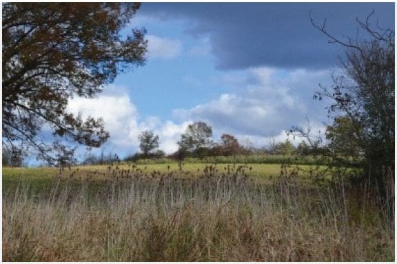
Property Record
County Route 66, T O Blooming Grove, NY 10918
NEARBY LISTINGS FOR SALE OR LEASE
Property Detail
County Route 66
New York-Jersey City-White Plains, NY-NJ
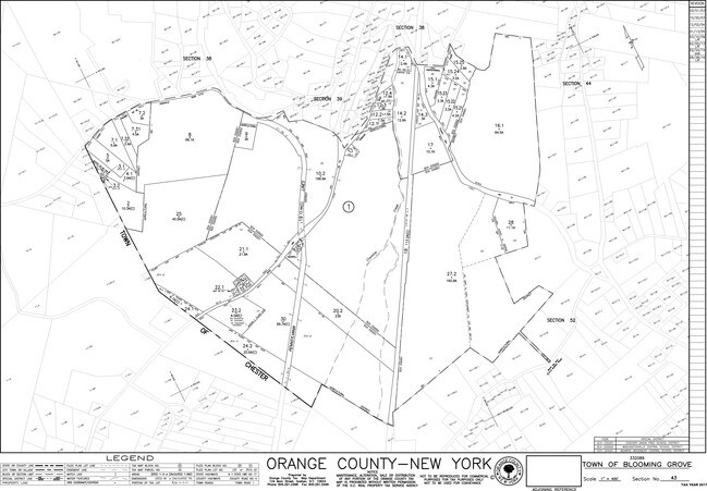
PT LT 1 MARI & PALMER SUB MAP 4929 PLAN #003
332089-043-000-0001-008.000-0000
Orange
Farms
New York
X
83.21
36071C0463E
66.10 AC
2024
Newburgh
2024
Northern New Jersey
014301
DEMOGRAPHICS near County Route 66
1 Mile
3 Mile
5 Mile
2024 Total Population
850
10,916
44,324
2029 Population
863
11,083
45,200
Pop Growth 2024-2029
+ 1.53%
+ 1.53%
+ 1.98%
Average Age
42
41
36
2024 Total Households
308
3,836
13,447
HH Growth 2024-2029
+ 1.62%
+ 1.54%
+ 2.07%
Median Household Inc
$77,976
$118,542
$103,077
Avg Household Size
2.70
2.80
3.10
2024 Avg HH Vehicles
2.00
2.00
2.00
Median Home Value
$343,367
$344,550
$374,197
Median Year Built
1965
1974
1978
Nearby Places
- Restaurants
- Banks
- Shops
- Fitness
- Groceries
PUBLIC TRANSPORTATION
COMMUTER RAIL
Campbell Hall (Bergen County/Port Jervis Line - NJ Transit Commuter Rail (NJ Transit), Main/Port Jervis Line - NJ Transit Commuter Rail (NJ Transit))
DRIVE
WALK
Distance
Campbell Hall (Bergen County/Port Jervis Line - NJ Transit Commuter Rail (NJ Transit), Main/Port Jervis Line - NJ Transit Commuter Rail (NJ Transit))
17 min
6.6 mi
AIRPORT
New York Stewart International
DRIVE
WALK
Distance
New York Stewart International
26 min
13.0 mi
Freight Ports
Port Newark Container Terminal
DRIVE
WALK
Distance
Port Newark Container Terminal
87 min
64.4 mi
SALE & LEASE HISTORY
LISTING DATE
SALE/LEASE

Sep 24, 2016
For Sale
Nov 05, 2017
For Sale
Nearby Properties
Address
Land Use
TOTAL SIZE
Lot Size
Zoning
Address
Land Use
TOTAL SIZE
Lot Size
Zoning
1,313,710 SF
34 AC
SR2*
Address
Land Use
TOTAL SIZE
Lot Size
Zoning
198,260 SF
27.60 AC
B2
Address
Land Use
TOTAL SIZE
Lot Size
Zoning
100,324 SF
0.66 AC
RS
Address
Land Use
TOTAL SIZE
Lot Size
Zoning
282,147 SF
7.50 AC
M2
Address
Land Use
TOTAL SIZE
Lot Size
Zoning
71,910 SF
10.80 AC
Address
Land Use
TOTAL SIZE
Lot Size
Zoning
86,696 SF
153.50 AC
A1OP
Address
Land Use
TOTAL SIZE
Lot Size
Zoning
19,440 SF
6.80 AC
RM
Address
Land Use
TOTAL SIZE
Lot Size
Zoning
82,927 SF
10.10 AC
4500
Address
Land Use
TOTAL SIZE
Lot Size
Zoning
43,664 SF
3.10 AC
B2
Address
Land Use
TOTAL SIZE
Lot Size
Zoning
43,738 SF
16.90 AC
GC
Address
Land Use
TOTAL SIZE
Lot Size
Zoning
43,952 SF
14.10 AC
B2
Address
Land Use
TOTAL SIZE
Lot Size
Zoning
72,430 SF
5.60 AC
M2
Address
Land Use
TOTAL SIZE
Lot Size
Zoning
6,048 SF
145.80 AC
R4A
Address
Land Use
TOTAL SIZE
Lot Size
Zoning
946 SF
227.80 AC
R4A*
Address
Land Use
TOTAL SIZE
Lot Size
Zoning
33,380 SF
2.60 AC
B2
Address
Land Use
TOTAL SIZE
Lot Size
Zoning
6,562 SF
104.80 AC
01092
Address
Land Use
TOTAL SIZE
Lot Size
Zoning
Address
Land Use
TOTAL SIZE
Lot Size
Zoning
4,312 SF
83.80 AC
AR3
Address
Land Use
TOTAL SIZE
Lot Size
Zoning
33,059 SF
2.70 AC
RM
Address
Land Use
TOTAL SIZE
Lot Size
Zoning
25,427 SF
3.20 AC
Address
Land Use
TOTAL SIZE
Lot Size
Zoning
353.60 AC
01092
Address
Land Use
TOTAL SIZE
Lot Size
Zoning
25,222 SF
3.60 AC
04100
Address
Land Use
TOTAL SIZE
Lot Size
Zoning
1,288 SF
51.20 AC
R4A*
Address
Land Use
TOTAL SIZE
Lot Size
Zoning
19,119 SF
3.30 AC
B2
Address
Land Use
TOTAL SIZE
Lot Size
Zoning
8,590 SF
4 AC
4500
Address
Land Use
TOTAL SIZE
Lot Size
Zoning
2,952 SF
1.40 AC
B2
Address
Land Use
TOTAL SIZE
Lot Size
Zoning
2,664 SF
119.20 AC
R4A
Address
Land Use
TOTAL SIZE
Lot Size
Zoning
1,008 SF
124 AC
R4A
Address
Land Use
TOTAL SIZE
Lot Size
Zoning
4,418 SF
76.30 AC
R4A
Address
Land Use
TOTAL SIZE
Lot Size
Zoning
10,764 SF
128.20 AC
01184
The World's #1 Commercial Real Estate Marketplace
Connect with us
© 2025 CoStar Group
The information above has been obtained from sources believed reliable. While we do not doubt its accuracy we have not verified it and make no guarantee, warranty or representation about it. It is your responsibility to independently confirm its accuracy and completeness. Any projections, opinions, assumptions, or estimates used are for example only and do not represent the current or future performance of the property. The value of this transaction to you depends on tax and other factors which should be evaluated by your tax, financial, and legal advisors. You and your advisors should conduct a careful, independent investigation of the property to determine to your satisfaction the suitability of the property for your needs.