Property Record
R114 C R 1143, , TX
NEARBY LISTINGS FOR SALE OR LEASE
Property Detail
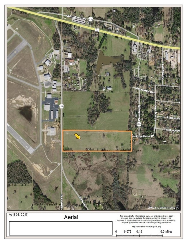
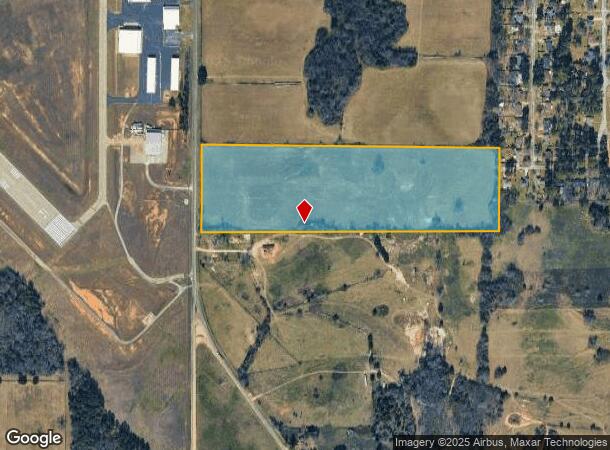
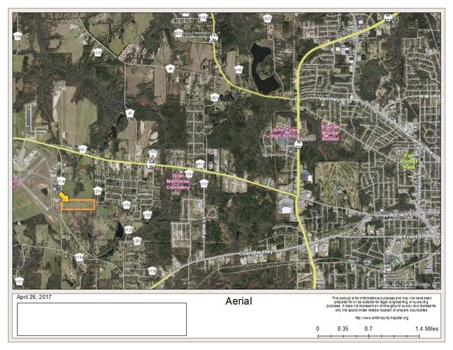
R114 C R 1143
Tyler, TX
A0643 G Myers
1-00000-0643-02-060000
ABST A0643 G MYERSTRACT 60
Pasture
Smith
X
Texas
48423C0350D
25.80 AC
2024
Tyler & Longview
2025
Other Market Areas
001607
DEMOGRAPHICS near R114 C R 1143
1 Mile
3 Mile
5 Mile
2024 Total Population
1,810
11,395
43,584
2029 Population
1,954
12,428
47,560
Pop Growth 2024-2029
+ 7.96%
+ 9.07%
+ 9.12%
Average Age
39
38
37
2024 Total Households
677
4,082
15,783
HH Growth 2024-2029
+ 7.39%
+ 8.48%
+ 8.59%
Median Household Inc
$63,424
$59,456
$48,576
Avg Household Size
2.50
2.70
2.60
2024 Avg HH Vehicles
2.00
2.00
2.00
Median Home Value
$146,408
$147,494
$125,301
Median Year Built
1976
1976
1971
Nearby Places
Map Layers
Map Styles
 Street
 Aerial
- Restaurants
- Banks
- Shops
- Fitness
- Groceries
PUBLIC TRANSPORTATION
AIRPORT
Tyler Pounds Regional
DRIVE
WALK
Distance
Tyler Pounds Regional
9 min
3.0 mi
Freight Ports
Port of Shreveport
DRIVE
WALK
Distance
Port of Shreveport
131 min
112.4 mi
SALE & LEASE HISTORY
LISTING DATE
SALE/LEASE

Sep 24, 2019
For Sale
Jul 26, 2017
For Lease
Apr 28, 2017
For Sale
Nearby Properties
Address
Land Use
TOTAL SIZE
Lot Size
Zoning
Address
Land Use
TOTAL SIZE
Lot Size
Zoning
187.64 AC
R1A
Address
Land Use
TOTAL SIZE
Lot Size
Zoning
311.96 AC
Address
Land Use
TOTAL SIZE
Lot Size
Zoning
63 AC
R1A
Address
Land Use
TOTAL SIZE
Lot Size
Zoning
22.85 AC
Address
Land Use
TOTAL SIZE
Lot Size
Zoning
2,802 SF
14 AC
RMF
Address
Land Use
TOTAL SIZE
Lot Size
Zoning
Address
Land Use
TOTAL SIZE
Lot Size
Zoning
14.16 AC
Address
Land Use
TOTAL SIZE
Lot Size
Zoning
205,196 SF
25.19 AC
C2
Address
Land Use
TOTAL SIZE
Lot Size
Zoning
25.57 AC
Address
Land Use
TOTAL SIZE
Lot Size
Zoning
239,900 SF
52.09 AC
Address
Land Use
TOTAL SIZE
Lot Size
Zoning
135,792 SF
12.05 AC
C1
Address
Land Use
TOTAL SIZE
Lot Size
Zoning
1,868 SF
2.24 AC
Address
Land Use
TOTAL SIZE
Lot Size
Zoning
92,268 SF
8.48 AC
C2
Address
Land Use
TOTAL SIZE
Lot Size
Zoning
352.91 AC
OSP
Address
Land Use
TOTAL SIZE
Lot Size
Zoning
64,882 SF
6.07 AC
C1
Address
Land Use
TOTAL SIZE
Lot Size
Zoning
32,175 SF
3.48 AC
C2
Address
Land Use
TOTAL SIZE
Lot Size
Zoning
4,747 SF
42.83 AC
Address
Land Use
TOTAL SIZE
Lot Size
Zoning
12,355 SF
7 AC
Address
Land Use
TOTAL SIZE
Lot Size
Zoning
8,195 SF
3.13 AC
Address
Land Use
TOTAL SIZE
Lot Size
Zoning
55,840 SF
6.39 AC
Address
Land Use
TOTAL SIZE
Lot Size
Zoning
17,000 SF
89.17 AC
Address
Land Use
TOTAL SIZE
Lot Size
Zoning
24,912 SF
3.60 AC
RMF
Address
Land Use
TOTAL SIZE
Lot Size
Zoning
6,038 SF
1.38 AC
Address
Land Use
TOTAL SIZE
Lot Size
Zoning
20.10 AC
R1A
Address
Land Use
TOTAL SIZE
Lot Size
Zoning
21,041 SF
10.63 AC
M1
Address
Land Use
TOTAL SIZE
Lot Size
Zoning
4.97 AC
R1A
Address
Land Use
TOTAL SIZE
Lot Size
Zoning
25,000 SF
12.09 AC
Address
Land Use
TOTAL SIZE
Lot Size
Zoning
60,000 SF
10.72 AC
M1
Address
Land Use
TOTAL SIZE
Lot Size
Zoning
6,289 SF
12.66 AC
Address
Land Use
TOTAL SIZE
Lot Size
Zoning
17,617 SF
8.88 AC
The World's #1 Commercial Real Estate Marketplace
Connect with us
© 2025 CoStar Group
The information above has been obtained from sources believed reliable. While we do not doubt its accuracy we have not verified it and make no guarantee, warranty or representation about it. It is your responsibility to independently confirm its accuracy and completeness. Any projections, opinions, assumptions, or estimates used are for example only and do not represent the current or future performance of the property. The value of this transaction to you depends on tax and other factors which should be evaluated by your tax, financial, and legal advisors. You and your advisors should conduct a careful, independent investigation of the property to determine to your satisfaction the suitability of the property for your needs.