Property Record
County Road 64, Rosharon, TX 77583
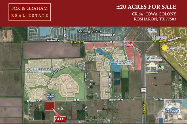

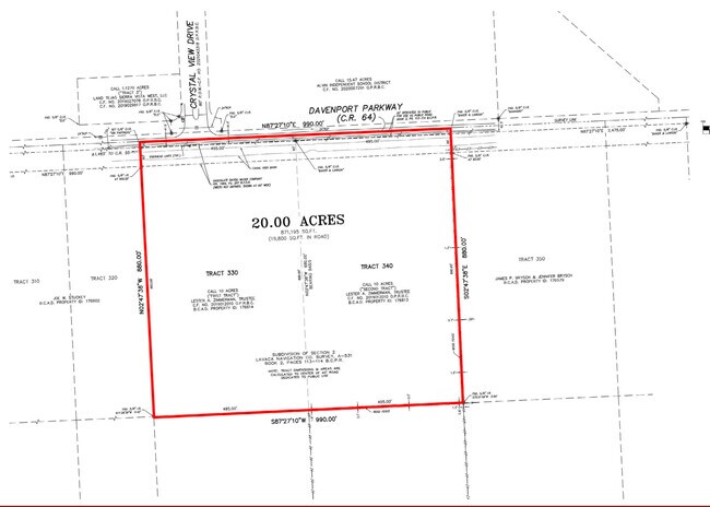
This Property Is For Sale
Property Detail
County Road 64
0531-0050-000
A0531 C M HAYS TRACT 330 ACRES 10.00
Agriculturalland
BRAZORIA
0047
Texas
AE The base floodplain where base flood elevations are provided. AE Zones are now used on new format FIRMs instead of A1-A30 Zones.
10 AC
2024
South Hwy 35
2025
Houston
661900
Houston-Pasadena-The Woodlands, TX
NEARBY LISTINGS FOR SALE OR LEASE
-
-
-
-
No Photo
-
-
-
-
View all Rosharon listings for sale on LoopNet.com
DEMOGRAPHICS near County Road 64
1 mile
3 mile
5 mile
2025 Total Population
3,172
17,891
35,174
2030 Population
3,644
20,573
40,919
Pop Growth 2025-2030
+ 14.88%
+ 14.99%
+ 16.33%
Average Age
34
35
35
2025 Total Households
967
5,114
10,483
HH Growth 2025-2030
+ 15.20%
+ 16.33%
+ 17.20%
Median Household Inc
$99,804
$100,143
$102,598
Avg Household Size
3.30
3.20
3.20
2025 Avg HH Vehicles
2.00
2.00
2.00
Median Home Value
$336,318
$347,523
$355,254
Median Year Built
2011
2011
2010
Nearby Places
Map Layers
Map Styles
 Street
 Aerial
Transit
 Traffic
 Biking
Places
Listings with unknown addresses are not visible on the map
- Restaurants
- Banks
- Shops
- Fitness
- Groceries
PUBLIC TRANSPORTATION
AIRPORT
William P Hobby
Drive
Walk
Distance
William P Hobby
41 min
23.9 mi
Freight Ports
Port of Houston
Drive
Walk
Distance
Port of Houston
46 min
30.7 mi
Nearby Properties
Address
Land Use
TOTAL SIZE
Lot Size
Zoning
Address
Land Use
TOTAL SIZE
Lot Size
Zoning
170.62 AC
Address
Land Use
TOTAL SIZE
Lot Size
Zoning
Address
Land Use
TOTAL SIZE
Lot Size
Zoning
2,727.82 AC
0002
Address
Land Use
TOTAL SIZE
Lot Size
Zoning
199,508 SF
18.04 AC
Address
Land Use
TOTAL SIZE
Lot Size
Zoning
121,138 SF
11.52 AC
Address
Land Use
TOTAL SIZE
Lot Size
Zoning
202,496 SF
11.94 AC
Address
Land Use
TOTAL SIZE
Lot Size
Zoning
65,403 SF
14.65 AC
Address
Land Use
TOTAL SIZE
Lot Size
Zoning
4,400.55 AC
0009
Address
Land Use
TOTAL SIZE
Lot Size
Zoning
14,968 SF
1.81 AC
Address
Land Use
TOTAL SIZE
Lot Size
Zoning
47,500 SF
Address
Land Use
TOTAL SIZE
Lot Size
Zoning
16,298 SF
2.87 AC
Address
Land Use
TOTAL SIZE
Lot Size
Zoning
17,250 SF
2.39 AC
Address
Land Use
TOTAL SIZE
Lot Size
Zoning
91.43 AC
SQ
Address
Land Use
TOTAL SIZE
Lot Size
Zoning
7,298 SF
7.97 AC
Address
Land Use
TOTAL SIZE
Lot Size
Zoning
1.86 AC
Address
Land Use
TOTAL SIZE
Lot Size
Zoning
14,726 SF
1.80 AC
Address
Land Use
TOTAL SIZE
Lot Size
Zoning
41,540 SF
5.71 AC
Address
Land Use
TOTAL SIZE
Lot Size
Zoning
17,700 SF
2.59 AC
Address
Land Use
TOTAL SIZE
Lot Size
Zoning
4,743 SF
1.35 AC
Address
Land Use
TOTAL SIZE
Lot Size
Zoning
1.56 AC
Address
Land Use
TOTAL SIZE
Lot Size
Zoning
7,795 SF
4.30 AC
Address
Land Use
TOTAL SIZE
Lot Size
Zoning
10,080 SF
4.06 AC
Address
Land Use
TOTAL SIZE
Lot Size
Zoning
7,256 SF
1.91 AC
Address
Land Use
TOTAL SIZE
Lot Size
Zoning
41,670 SF
8.60 AC
0007
Address
Land Use
TOTAL SIZE
Lot Size
Zoning
7,946 SF
2.31 AC
Address
Land Use
TOTAL SIZE
Lot Size
Zoning
7,200 SF
1.91 AC
0011
Address
Land Use
TOTAL SIZE
Lot Size
Zoning
22,650 SF
10 AC
0027
Address
Land Use
TOTAL SIZE
Lot Size
Zoning
13,075 SF
1.57 AC
Address
Land Use
TOTAL SIZE
Lot Size
Zoning
10.40 AC
Address
Land Use
TOTAL SIZE
Lot Size
Zoning
15,750 SF
14.46 AC
The World's #1 Commercial Real Estate Marketplace
Connect with us
© 2026 CoStar Group
The information above has been obtained from sources believed reliable. While we do not doubt its accuracy we have not verified it and make no guarantee, warranty or representation about it. It is your responsibility to independently confirm its accuracy and completeness. Any projections, opinions, assumptions, or estimates used are for example only and do not represent the current or future performance of the property. The value of this transaction to you depends on tax and other factors which should be evaluated by your tax, financial, and legal advisors. You and your advisors should conduct a careful, independent investigation of the property to determine to your satisfaction the suitability of the property for your needs.