Property Record
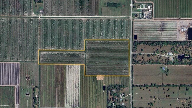
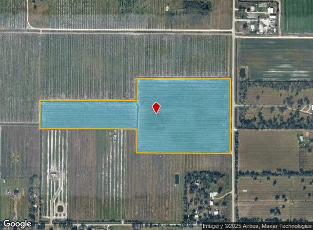
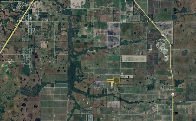
Se County Road 763, Arcadia, FL 34266
This Property Is For Sale
NEARBY LISTINGS FOR SALE OR LEASE
-
-
View all Arcadia listings for sale on LoopNet.com
Property Detail
Se County Road 763
05-39-25-0000-0151-0000
S1/2 OF NE1/4 OF NE1/4 LESS HOG BAY RD ON E SIDE & N1/2 OF N1/2 OF SE1/4 OF NE1/4 LESS HOG BAY RD ON E SIDE & S1/2 OF S1/2 OF NW1/4 OF NE1/4 ALL LYG & BETWEEN SECTION 5 & ALSO N 30 FT OF E1/2 OF E1/2 OF SW1/4 OF NE1/4 & BEG NW COR OF S1/2 OF N1/2 OF
Orchard
DeSoto
X
Florida
12015C0125G
40.99 AC
2024
Florida Central South Area
2024
Other Market Areas
010302
Arcadia, FL
DEMOGRAPHICS near Se County Road 763
1 Mile
3 Mile
5 Mile
2024 Total Population
107
850
6,780
2029 Population
126
1,005
7,913
Pop Growth 2024-2029
+ 17.76%
+ 18.24%
+ 16.71%
Average Age
40
41
42
2024 Total Households
39
290
1,849
HH Growth 2024-2029
+ 17.95%
+ 20.34%
+ 20.66%
Median Household Inc
$74,999
$71,835
$66,060
Avg Household Size
2.70
2.80
2.80
2024 Avg HH Vehicles
2.00
2.00
2.00
Median Home Value
$437,500
$304,000
$231,330
Median Year Built
1998
1995
1990
Nearby Places
- Restaurants
- Banks
- Shops
- Fitness
- Groceries
PUBLIC TRANSPORTATION
AIRPORT
Punta Gorda
DRIVE
WALK
Distance
Punta Gorda
43 min
26.4 mi
Freight Ports
Port Manatee
DRIVE
WALK
Distance
Port Manatee
94 min
65.8 mi
Nearby Properties
Address
Land Use
TOTAL SIZE
Lot Size
Zoning
Address
Land Use
TOTAL SIZE
Lot Size
Zoning
480 AC
A-10
Address
Land Use
TOTAL SIZE
Lot Size
Zoning
56,776 SF
14.75 AC
PUD
Address
Land Use
TOTAL SIZE
Lot Size
Zoning
105,694 SF
28 AC
PUD
Address
Land Use
TOTAL SIZE
Lot Size
Zoning
64,927 SF
41.08 AC
PUD
Address
Land Use
TOTAL SIZE
Lot Size
Zoning
9,422 SF
640 AC
A-10
Address
Land Use
TOTAL SIZE
Lot Size
Zoning
468 SF
160 AC
A-10
Address
Land Use
TOTAL SIZE
Lot Size
Zoning
30,557 SF
86.31 AC
A-10
Address
Land Use
TOTAL SIZE
Lot Size
Zoning
1,656 SF
160 AC
A-10
Address
Land Use
TOTAL SIZE
Lot Size
Zoning
21,003 SF
25.88 AC
PUD
Address
Land Use
TOTAL SIZE
Lot Size
Zoning
5,888 SF
640 AC
A-10
Address
Land Use
TOTAL SIZE
Lot Size
Zoning
10,457 SF
631 AC
A-10
Address
Land Use
TOTAL SIZE
Lot Size
Zoning
201,738 SF
29.57 AC
PUD
Address
Land Use
TOTAL SIZE
Lot Size
Zoning
634.37 AC
A-10
Address
Land Use
TOTAL SIZE
Lot Size
Zoning
57,305 SF
11.74 AC
PUD
Address
Land Use
TOTAL SIZE
Lot Size
Zoning
640 AC
A-10
Address
Land Use
TOTAL SIZE
Lot Size
Zoning
19,550 SF
80 AC
A-10
Address
Land Use
TOTAL SIZE
Lot Size
Zoning
25,804 SF
347.75 AC
PUD
Address
Land Use
TOTAL SIZE
Lot Size
Zoning
224.21 AC
A-10
Address
Land Use
TOTAL SIZE
Lot Size
Zoning
4,220 SF
312.23 AC
A-5
Address
Land Use
TOTAL SIZE
Lot Size
Zoning
90 AC
A-10
Address
Land Use
TOTAL SIZE
Lot Size
Zoning
62.26 AC
IL
Address
Land Use
TOTAL SIZE
Lot Size
Zoning
5,940 SF
1.25 AC
RSF-3
Address
Land Use
TOTAL SIZE
Lot Size
Zoning
13,642 SF
124.26 AC
A-5
Address
Land Use
TOTAL SIZE
Lot Size
Zoning
22.88 AC
RSF-2
Address
Land Use
TOTAL SIZE
Lot Size
Zoning
7,598 SF
80 AC
A-5
Address
Land Use
TOTAL SIZE
Lot Size
Zoning
5,329 SF
15.27 AC
A-5
Address
Land Use
TOTAL SIZE
Lot Size
Zoning
3,720 SF
148.02 AC
A-5
Address
Land Use
TOTAL SIZE
Lot Size
Zoning
58,263 SF
5.29 AC
PUD
Address
Land Use
TOTAL SIZE
Lot Size
Zoning
3,736 SF
39.50 AC
A-10
Address
Land Use
TOTAL SIZE
Lot Size
Zoning
8,891 SF
25.50 AC
A-5
The World's #1 Commercial Real Estate Marketplace
Connect with us
© 2025 CoStar Group
The information above has been obtained from sources believed reliable. While we do not doubt its accuracy we have not verified it and make no guarantee, warranty or representation about it. It is your responsibility to independently confirm its accuracy and completeness. Any projections, opinions, assumptions, or estimates used are for example only and do not represent the current or future performance of the property. The value of this transaction to you depends on tax and other factors which should be evaluated by your tax, financial, and legal advisors. You and your advisors should conduct a careful, independent investigation of the property to determine to your satisfaction the suitability of the property for your needs.