Property Record
Crain Hwy, Crofton, MD 21114

NEARBY LISTINGS FOR SALE OR LEASE
Property Detail
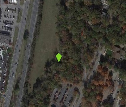
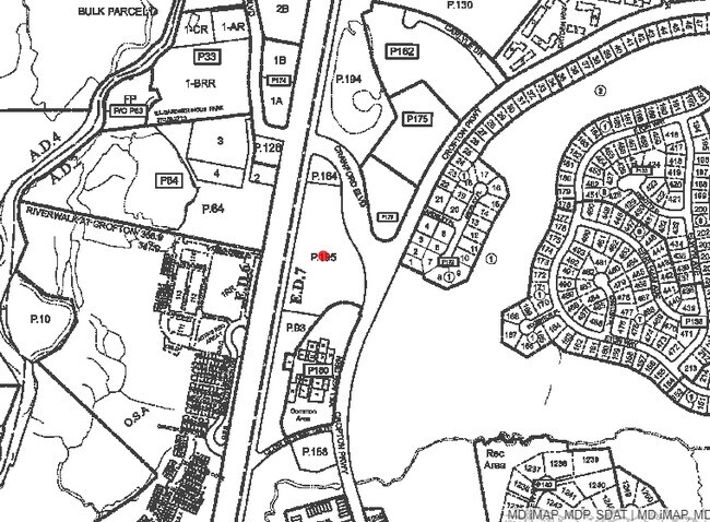
Crain Hwy
02-205-90045313
Priest Bridge
Commercialacreage
6.94 ACRES OR RESIDU CRAIN HWY PRIEST BRIDGE
A
Anne Arundel
24033C0090E
Maryland
2024
6.94 AC
2025
I-97/Crain Hwy Corridor
702205
Baltimore
1,376 SF
Baltimore-Columbia-Towson, MD
DEMOGRAPHICS near Crain Hwy
1 Mile
3 Mile
5 Mile
2024 Total Population
8,685
48,203
108,005
2029 Population
8,884
49,192
108,438
Pop Growth 2024-2029
+ 2.29%
+ 2.05%
+ 0.40%
Average Age
39
40
40
2024 Total Households
3,308
17,483
39,091
HH Growth 2024-2029
+ 2.57%
+ 2.33%
+ 0.57%
Median Household Inc
$112,461
$133,071
$128,469
Avg Household Size
2.60
2.70
2.70
2024 Avg HH Vehicles
2.00
2.00
2.00
Median Home Value
$501,323
$477,159
$430,578
Median Year Built
1975
1989
1988
Nearby Places
Map Layers
Map Styles
 Street
 Aerial
- Restaurants
- Banks
- Shops
- Fitness
- Groceries
PUBLIC TRANSPORTATION
COMMUTER RAIL
Bowie State Marc Nb (PENN - WASHINGTON - Maryland Transit Administration)
DRIVE
WALK
Distance
Bowie State Marc Nb (PENN - WASHINGTON - Maryland Transit Administration)
15 min
6.8 mi
Bowie State Marc Sb (PENN - WASHINGTON - Maryland Transit Administration)
DRIVE
WALK
Distance
Bowie State Marc Sb (PENN - WASHINGTON - Maryland Transit Administration)
15 min
8.2 mi
AIRPORT
Baltimore/Washington International Thurgood Marshall
DRIVE
WALK
Distance
Baltimore/Washington International Thurgood Marshall
27 min
17.7 mi
Ronald Reagan Washington Ntl
DRIVE
WALK
Distance
Ronald Reagan Washington Ntl
40 min
27.2 mi
Freight Ports
Port of Baltimore
DRIVE
WALK
Distance
Port of Baltimore
35 min
23.2 mi
Nearby Properties
Address
Land Use
TOTAL SIZE
Lot Size
Zoning
Address
Land Use
TOTAL SIZE
Lot Size
Zoning
444,842 SF
19.48 AC
R22
Address
Land Use
TOTAL SIZE
Lot Size
Zoning
360,354 SF
7.36 AC
MXD-C
Address
Land Use
TOTAL SIZE
Lot Size
Zoning
246,000 SF
15.73 AC
MXDR
Address
Land Use
TOTAL SIZE
Lot Size
Zoning
273,816 SF
44.22 AC
MXD-C
Address
Land Use
TOTAL SIZE
Lot Size
Zoning
80,321 SF
11.78 AC
CGO
Address
Land Use
TOTAL SIZE
Lot Size
Zoning
287,439 SF
19.97 AC
CGO
Address
Land Use
TOTAL SIZE
Lot Size
Zoning
8.70 AC
R15
Address
Land Use
TOTAL SIZE
Lot Size
Zoning
159,944 SF
5.34 AC
C1
Address
Land Use
TOTAL SIZE
Lot Size
Zoning
101,475 SF
11.17 AC
CGO
Address
Land Use
TOTAL SIZE
Lot Size
Zoning
8.38 AC
R22
Address
Land Use
TOTAL SIZE
Lot Size
Zoning
108,480 SF
17.66 AC
C4
Address
Land Use
TOTAL SIZE
Lot Size
Zoning
72,925 SF
4.12 AC
MXR
Address
Land Use
TOTAL SIZE
Lot Size
Zoning
47,744 SF
1.79 AC
MXD-C
Address
Land Use
TOTAL SIZE
Lot Size
Zoning
39,695 SF
11.66 AC
C4
Address
Land Use
TOTAL SIZE
Lot Size
Zoning
111,450 SF
154.81 AC
R1
Address
Land Use
TOTAL SIZE
Lot Size
Zoning
134,923 SF
8.35 AC
MXD-C
Address
Land Use
TOTAL SIZE
Lot Size
Zoning
86,496 SF
6.86 AC
R5
Address
Land Use
TOTAL SIZE
Lot Size
Zoning
87,919 SF
9.71 AC
R5
Address
Land Use
TOTAL SIZE
Lot Size
Zoning
112,028 SF
40.41 AC
R1
Address
Land Use
TOTAL SIZE
Lot Size
Zoning
63,000 SF
22.90 AC
R1
Address
Land Use
TOTAL SIZE
Lot Size
Zoning
29,161 SF
3.98 AC
MXD-C
Address
Land Use
TOTAL SIZE
Lot Size
Zoning
91,592 SF
9.51 AC
C3
Address
Land Use
TOTAL SIZE
Lot Size
Zoning
78,930 SF
9.24 AC
R5
Address
Land Use
TOTAL SIZE
Lot Size
Zoning
74,054 SF
1.40 AC
R1
Address
Land Use
TOTAL SIZE
Lot Size
Zoning
168,332 SF
20.65 AC
C3
Address
Land Use
TOTAL SIZE
Lot Size
Zoning
48,979 SF
1.64 AC
R1
Address
Land Use
TOTAL SIZE
Lot Size
Zoning
80,984 SF
15 AC
R5
Address
Land Use
TOTAL SIZE
Lot Size
Zoning
19.10 AC
W1B
Address
Land Use
TOTAL SIZE
Lot Size
Zoning
41,110 SF
54.39 AC
RA
The World's #1 Commercial Real Estate Marketplace
Connect with us
© 2025 CoStar Group
The information above has been obtained from sources believed reliable. While we do not doubt its accuracy we have not verified it and make no guarantee, warranty or representation about it. It is your responsibility to independently confirm its accuracy and completeness. Any projections, opinions, assumptions, or estimates used are for example only and do not represent the current or future performance of the property. The value of this transaction to you depends on tax and other factors which should be evaluated by your tax, financial, and legal advisors. You and your advisors should conduct a careful, independent investigation of the property to determine to your satisfaction the suitability of the property for your needs.