Property Record
1001 Taylors Ln, Cinnaminson, NJ 08077
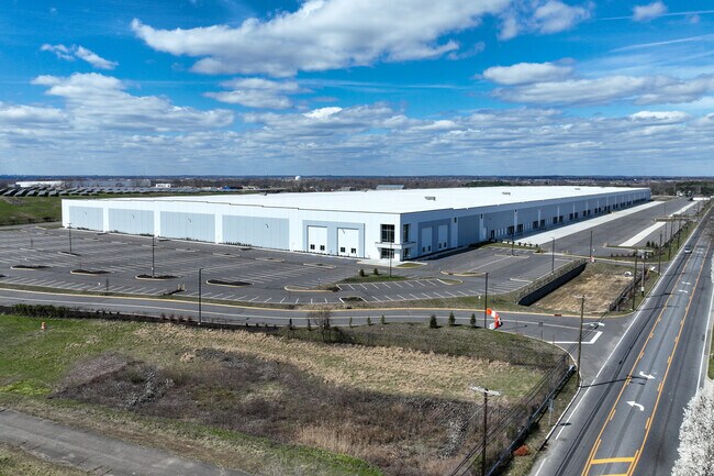

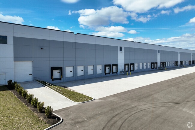
Property Detail
1001 Taylors Ln
Philadelphia-Camden-Wilmington, PA-NJ-DE-MD
ADDITIONAL LOTS: 564424 SQFT MFG
08-00610-0000-00003
BURLINGTON
Industrialgeneral
New Jersey
B and X Area of moderate flood hazard, usually the area between the limits of the 100-year and 500-year floods.
3.2
2024
10.92 AC
2025
Burlington
700303
Philadelphia
NEARBY LISTINGS FOR SALE OR LEASE
DEMOGRAPHICS near 1001 Taylors Ln
1 mile
3 mile
5 mile
2025 Total Population
2,549
87,290
326,205
2030 Population
2,651
88,148
324,051
Pop Growth 2025-2030
+ 4.00%
+ 0.98%
(0.66%)
Average Age
40
42
40
2025 Total Households
971
34,065
122,697
HH Growth 2025-2030
+ 4.22%
+ 0.75%
(0.68%)
Median Household Inc
$102,484
$90,351
$74,821
Avg Household Size
2.60
2.50
2.60
2025 Avg HH Vehicles
2.00
2.00
2.00
Median Home Value
$337,162
$294,374
$268,487
Median Year Built
1969
1963
1959
Nearby Places
Map Layers
Map Styles
 Street
 Aerial
Layers
 Traffic
 Biking
Places
Listings with unknown addresses are not visible on the map
- Restaurants
- Banks
- Shops
- Fitness
- Groceries
PUBLIC TRANSPORTATION
TRANSIT/SUBWAY
Cinnaminson (River LINE - River LINE (River LINE))
Drive
Walk
Distance
Cinnaminson (River LINE - River LINE (River LINE))
5 min
16 min
0.8 mi
COMMUTER RAIL
Holmesburg Junction (R7 - Southeastern Pennsylvania Transportation Authority Regional Rail (SEPTA Regional Rail))
Drive
Walk
Distance
Holmesburg Junction (R7 - Southeastern Pennsylvania Transportation Authority Regional Rail (SEPTA Regional Rail))
17 min
7.2 mi
Torresdale (R7 - Southeastern Pennsylvania Transportation Authority Regional Rail (SEPTA Regional Rail))
Drive
Walk
Distance
Torresdale (R7 - Southeastern Pennsylvania Transportation Authority Regional Rail (SEPTA Regional Rail))
22 min
9.7 mi
AIRPORT
Philadelphia International
Drive
Walk
Distance
Philadelphia International
39 min
22.8 mi
Trenton Mercer
Drive
Walk
Distance
Trenton Mercer
44 min
26.3 mi
Freight Ports
Port of Philadelphia
Drive
Walk
Distance
Port of Philadelphia
20 min
10.4 mi
SALE & LEASE HISTORY
LISTING DATE
SALE/LEASE

Jul 08, 2020
For Lease
Nearby Properties
Address
Land Use
TOTAL SIZE
Lot Size
Zoning
Address
Land Use
TOTAL SIZE
Lot Size
Zoning
597,188 SF
120.50 AC
RM2
Address
Land Use
TOTAL SIZE
Lot Size
Zoning
95,280 SF
117.33 AC
I3
Address
Land Use
TOTAL SIZE
Lot Size
Zoning
37.21 AC
SPPOA
Address
Land Use
TOTAL SIZE
Lot Size
Zoning
2,550 SF
63.76 AC
SPPOA
Address
Land Use
TOTAL SIZE
Lot Size
Zoning
95.79 AC
Address
Land Use
TOTAL SIZE
Lot Size
Zoning
251,791 SF
15.59 AC
I2
Address
Land Use
TOTAL SIZE
Lot Size
Zoning
228,652 SF
12.81 AC
I1
Address
Land Use
TOTAL SIZE
Lot Size
Zoning
5.70 AC
R2
Address
Land Use
TOTAL SIZE
Lot Size
Zoning
437,192 SF
28.03 AC
I2
Address
Land Use
TOTAL SIZE
Lot Size
Zoning
22.49 AC
Address
Land Use
TOTAL SIZE
Lot Size
Zoning
27.33 AC
Address
Land Use
TOTAL SIZE
Lot Size
Zoning
82.32 AC
Address
Land Use
TOTAL SIZE
Lot Size
Zoning
19 AC
Address
Land Use
TOTAL SIZE
Lot Size
Zoning
24.56 AC
Address
Land Use
TOTAL SIZE
Lot Size
Zoning
205,472 SF
8.40 AC
RM2
Address
Land Use
TOTAL SIZE
Lot Size
Zoning
206,982 SF
8.32 AC
I2
Address
Land Use
TOTAL SIZE
Lot Size
Zoning
88,320 SF
21.03 AC
SPINS
Address
Land Use
TOTAL SIZE
Lot Size
Zoning
20.30 AC
Address
Land Use
TOTAL SIZE
Lot Size
Zoning
19.97 AC
Address
Land Use
TOTAL SIZE
Lot Size
Zoning
39.58 AC
Address
Land Use
TOTAL SIZE
Lot Size
Zoning
208,527 SF
7.80 AC
RM2
Address
Land Use
TOTAL SIZE
Lot Size
Zoning
25,842 SF
3.87 AC
RSA5
Address
Land Use
TOTAL SIZE
Lot Size
Zoning
152,835 SF
4.46 AC
RM2
Address
Land Use
TOTAL SIZE
Lot Size
Zoning
172,200 SF
5.72 AC
RM2
Address
Land Use
TOTAL SIZE
Lot Size
Zoning
Address
Land Use
TOTAL SIZE
Lot Size
Zoning
24.97 AC
SPPOA
Address
Land Use
TOTAL SIZE
Lot Size
Zoning
196,000 SF
11.98 AC
I1
Address
Land Use
TOTAL SIZE
Lot Size
Zoning
12,182 SF
47.21 AC
SPPOA
Address
Land Use
TOTAL SIZE
Lot Size
Zoning
17,380 SF
0.28 AC
SPCIV
Address
Land Use
TOTAL SIZE
Lot Size
Zoning
100,508 SF
1 AC
IRMX
The World's #1 Commercial Real Estate Marketplace
Connect with us
© 2026 CoStar Group
The information above has been obtained from sources believed reliable. While we do not doubt its accuracy we have not verified it and make no guarantee, warranty or representation about it. It is your responsibility to independently confirm its accuracy and completeness. Any projections, opinions, assumptions, or estimates used are for example only and do not represent the current or future performance of the property. The value of this transaction to you depends on tax and other factors which should be evaluated by your tax, financial, and legal advisors. You and your advisors should conduct a careful, independent investigation of the property to determine to your satisfaction the suitability of the property for your needs.