Property Record
Crandall Lanesville Rd, Corydon, IN 47112
NEARBY LISTINGS FOR SALE OR LEASE
-
-
View all Corydon listings for sale on LoopNet.com
Property Detail
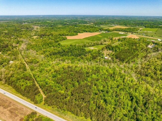
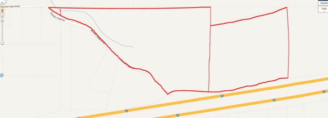
Crandall Lanesville Rd
Louisville-Jefferson County, KY-IN
PT NW1/4 NW QR 13-3-4 36.366
31-10-13-100-002.000-005
Harrison
Agriculturalland
Indiana
2024
36.37 AC
2024
Harrison County
060402
Louisville
DEMOGRAPHICS near Crandall Lanesville Rd
1 Mile
3 Mile
5 Mile
2024 Total Population
281
3,602
13,079
2029 Population
279
3,620
13,194
Pop Growth 2024-2029
(0.71%)
+ 0.50%
+ 0.88%
Average Age
44
43
41
2024 Total Households
112
1,417
5,050
HH Growth 2024-2029
(0.89%)
+ 0.35%
+ 0.85%
Median Household Inc
$88,157
$75,357
$77,405
Avg Household Size
2.50
2.50
2.60
2024 Avg HH Vehicles
3.00
3.00
2.00
Median Home Value
$263,888
$223,958
$213,575
Median Year Built
1982
1981
1984
Nearby Places
Map Layers
Map Styles
 Street
 Aerial
- Restaurants
- Banks
- Shops
- Fitness
- Groceries
PUBLIC TRANSPORTATION
AIRPORT
Louisville Muhammad Ali International
DRIVE
WALK
Distance
Louisville Muhammad Ali International
44 min
25.1 mi
Freight Ports
Port of Toledo
DRIVE
WALK
Distance
Port of Toledo
380 min
322.5 mi
SALE & LEASE HISTORY
LISTING DATE
SALE/LEASE

Mar 11, 2024
For Sale
Jul 11, 2023
For Sale
Nearby Properties
Address
Land Use
TOTAL SIZE
Lot Size
Zoning
Address
Land Use
TOTAL SIZE
Lot Size
Zoning
1,920 SF
19.87 AC
Address
Land Use
TOTAL SIZE
Lot Size
Zoning
65,208 SF
6.70 AC
Address
Land Use
TOTAL SIZE
Lot Size
Zoning
50,000 SF
7 AC
Address
Land Use
TOTAL SIZE
Lot Size
Zoning
9,696 SF
2.40 AC
Address
Land Use
TOTAL SIZE
Lot Size
Zoning
952 SF
26.39 AC
Address
Land Use
TOTAL SIZE
Lot Size
Zoning
Address
Land Use
TOTAL SIZE
Lot Size
Zoning
9,504 SF
1.09 AC
Address
Land Use
TOTAL SIZE
Lot Size
Zoning
Address
Land Use
TOTAL SIZE
Lot Size
Zoning
9,600 SF
4 AC
Address
Land Use
TOTAL SIZE
Lot Size
Zoning
5,628 SF
6.05 AC
Address
Land Use
TOTAL SIZE
Lot Size
Zoning
Address
Land Use
TOTAL SIZE
Lot Size
Zoning
4,000 SF
4.91 AC
Address
Land Use
TOTAL SIZE
Lot Size
Zoning
9,930 SF
1.38 AC
Address
Land Use
TOTAL SIZE
Lot Size
Zoning
56.70 AC
Address
Land Use
TOTAL SIZE
Lot Size
Zoning
12,528 SF
4 AC
Address
Land Use
TOTAL SIZE
Lot Size
Zoning
6,450 SF
65.92 AC
Address
Land Use
TOTAL SIZE
Lot Size
Zoning
1,426 SF
0.60 AC
Address
Land Use
TOTAL SIZE
Lot Size
Zoning
2,574 SF
0.28 AC
Address
Land Use
TOTAL SIZE
Lot Size
Zoning
3,248 SF
0.73 AC
Address
Land Use
TOTAL SIZE
Lot Size
Zoning
23.94 AC
Address
Land Use
TOTAL SIZE
Lot Size
Zoning
3,072 SF
0.15 AC
Address
Land Use
TOTAL SIZE
Lot Size
Zoning
9.23 AC
Address
Land Use
TOTAL SIZE
Lot Size
Zoning
104.90 AC
Address
Land Use
TOTAL SIZE
Lot Size
Zoning
7,440 SF
0.14 AC
Address
Land Use
TOTAL SIZE
Lot Size
Zoning
1,032 SF
80 AC
Address
Land Use
TOTAL SIZE
Lot Size
Zoning
176 AC
Address
Land Use
TOTAL SIZE
Lot Size
Zoning
2,809 SF
70.76 AC
Address
Land Use
TOTAL SIZE
Lot Size
Zoning
708 SF
118 AC
Address
Land Use
TOTAL SIZE
Lot Size
Zoning
137 AC
Address
Land Use
TOTAL SIZE
Lot Size
Zoning
109.61 AC
The World's #1 Commercial Real Estate Marketplace
Connect with us
© 2025 CoStar Group
The information above has been obtained from sources believed reliable. While we do not doubt its accuracy we have not verified it and make no guarantee, warranty or representation about it. It is your responsibility to independently confirm its accuracy and completeness. Any projections, opinions, assumptions, or estimates used are for example only and do not represent the current or future performance of the property. The value of this transaction to you depends on tax and other factors which should be evaluated by your tax, financial, and legal advisors. You and your advisors should conduct a careful, independent investigation of the property to determine to your satisfaction the suitability of the property for your needs.