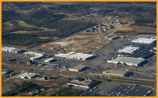
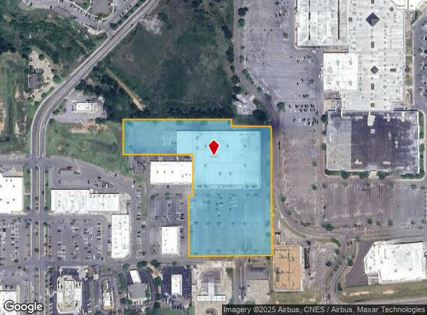
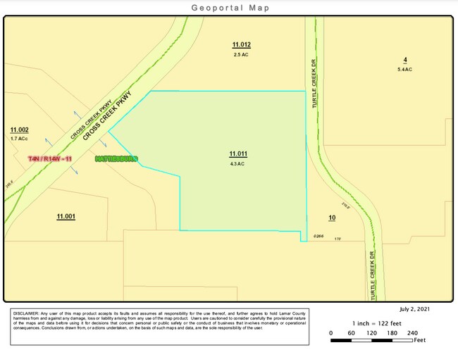
Property Record
6053 U S Highway 98, Hattiesburg, MS 39402
NEARBY LISTINGS FOR SALE OR LEASE
Property Detail
6053 U S Highway 98
051N-11-008.001
PT NW 1/4 SW 1/4 & PT S 1/2 S 1/2 SW 1/4 NW 1/4
Stripcommercialcenter
Lamar
X
Mississippi
28035C0085D
7 AC
2025
Hattiesburg/South Area
2025
Other Market Areas
020306
Hattiesburg, MS
94,588 SF
DEMOGRAPHICS near 6053 U S Highway 98
1 Mile
3 Mile
5 Mile
2024 Total Population
4,699
36,739
66,645
2029 Population
4,984
37,970
68,460
Pop Growth 2024-2029
+ 6.07%
+ 3.35%
+ 2.72%
Average Age
36
34
36
2024 Total Households
2,071
14,650
26,857
HH Growth 2024-2029
+ 5.99%
+ 3.62%
+ 2.78%
Median Household Inc
$56,216
$48,652
$49,636
Avg Household Size
2.20
2.20
2.30
2024 Avg HH Vehicles
1.00
2.00
2.00
Median Home Value
$152,100
$176,480
$177,521
Median Year Built
1999
1992
1988
Nearby Places
Map Layers
Map Styles
 Street
 Aerial
- Restaurants
- Banks
- Shops
- Fitness
- Groceries
PUBLIC TRANSPORTATION
COMMUTER RAIL
Hattiesburg Amtrak Station (Crescent - Amtrak)
DRIVE
WALK
Distance
Hattiesburg Amtrak Station (Crescent - Amtrak)
13 min
5.8 mi
Freight Ports
Port of Gulf Port
DRIVE
WALK
Distance
Port of Gulf Port
92 min
73.5 mi
SALE & LEASE HISTORY
LISTING DATE
SALE/LEASE

Nov 07, 2016
For Sale
Nearby Properties
Address
Land Use
TOTAL SIZE
Lot Size
Zoning
Address
Land Use
TOTAL SIZE
Lot Size
Zoning
254,642 SF
108.99 AC
Address
Land Use
TOTAL SIZE
Lot Size
Zoning
257,880 SF
0.03 AC
Address
Land Use
TOTAL SIZE
Lot Size
Zoning
39.41 AC
Address
Land Use
TOTAL SIZE
Lot Size
Zoning
56,369 SF
5.85 AC
Address
Land Use
TOTAL SIZE
Lot Size
Zoning
47,520 SF
36.20 AC
Address
Land Use
TOTAL SIZE
Lot Size
Zoning
73,760 SF
10 AC
Address
Land Use
TOTAL SIZE
Lot Size
Zoning
75,282 SF
23.42 AC
Address
Land Use
TOTAL SIZE
Lot Size
Zoning
62,017 SF
0.55 AC
Address
Land Use
TOTAL SIZE
Lot Size
Zoning
284,170 SF
17.21 AC
Address
Land Use
TOTAL SIZE
Lot Size
Zoning
48,864 SF
50 AC
Address
Land Use
TOTAL SIZE
Lot Size
Zoning
53,750 SF
5 AC
Address
Land Use
TOTAL SIZE
Lot Size
Zoning
5,551 SF
12.96 AC
Address
Land Use
TOTAL SIZE
Lot Size
Zoning
203,916 SF
Address
Land Use
TOTAL SIZE
Lot Size
Zoning
23,042 SF
14.40 AC
Address
Land Use
TOTAL SIZE
Lot Size
Zoning
4,785 SF
20.30 AC
Address
Land Use
TOTAL SIZE
Lot Size
Zoning
32,398 SF
6 AC
Address
Land Use
TOTAL SIZE
Lot Size
Zoning
2,447 SF
10.19 AC
Address
Land Use
TOTAL SIZE
Lot Size
Zoning
18,486 SF
5.40 AC
Address
Land Use
TOTAL SIZE
Lot Size
Zoning
25,684 SF
24 AC
Address
Land Use
TOTAL SIZE
Lot Size
Zoning
19,253 SF
30 AC
Address
Land Use
TOTAL SIZE
Lot Size
Zoning
5.93 AC
Address
Land Use
TOTAL SIZE
Lot Size
Zoning
25,838 SF
12.50 AC
Address
Land Use
TOTAL SIZE
Lot Size
Zoning
117,063 SF
38.70 AC
Address
Land Use
TOTAL SIZE
Lot Size
Zoning
3,249 SF
13.45 AC
Address
Land Use
TOTAL SIZE
Lot Size
Zoning
104,984 SF
0.86 AC
Address
Land Use
TOTAL SIZE
Lot Size
Zoning
5,375 SF
11.12 AC
Address
Land Use
TOTAL SIZE
Lot Size
Zoning
8,806 SF
16.95 AC
Address
Land Use
TOTAL SIZE
Lot Size
Zoning
23,031 SF
9.10 AC
Address
Land Use
TOTAL SIZE
Lot Size
Zoning
60,054 SF
9.62 AC
Address
Land Use
TOTAL SIZE
Lot Size
Zoning
9,240 SF
0.97 AC
The World's #1 Commercial Real Estate Marketplace
Connect with us
© 2025 CoStar Group
The information above has been obtained from sources believed reliable. While we do not doubt its accuracy we have not verified it and make no guarantee, warranty or representation about it. It is your responsibility to independently confirm its accuracy and completeness. Any projections, opinions, assumptions, or estimates used are for example only and do not represent the current or future performance of the property. The value of this transaction to you depends on tax and other factors which should be evaluated by your tax, financial, and legal advisors. You and your advisors should conduct a careful, independent investigation of the property to determine to your satisfaction the suitability of the property for your needs.