Property Record
Curle Rd, Eustis, FL 32736
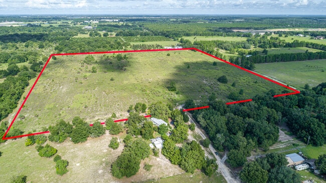


This Property Is For Sale
Property Detail
Curle Rd
Orlando-Kissimmee-Sanford, FL
NE 1/4 OF SW 1/4 ORB 4095 PBS 1512 1515 1510 ORB 4328 PG 64 ORB 4610 PG 857 ORB 5538 PG 16
14-19-27-0003-000-00500
LAKE
Commercialacreage
Florida
RA
5
A Areas with a 1% annual chance of flooding and a 26% chance of flooding over the life of a 30-year mortgage.
40.09 AC
2024
Lake County
2026
Orlando
030108
NEARBY LISTINGS FOR SALE OR LEASE
DEMOGRAPHICS near Curle Rd
1 mile
3 mile
5 mile
2025 Total Population
570
16,505
53,315
2030 Population
645
18,827
60,634
Pop Growth 2025-2030
+ 13.16%
+ 14.07%
+ 13.73%
Average Age
44
46
44
2025 Total Households
208
6,510
21,163
HH Growth 2025-2030
+ 12.98%
+ 14.18%
+ 13.87%
Median Household Inc
$119,470
$101,653
$85,150
Avg Household Size
2.60
2.50
2.50
2025 Avg HH Vehicles
2.00
2.00
2.00
Median Home Value
$530,303
$427,896
$382,726
Median Year Built
1999
2005
1997
Nearby Places
Map Layers
Map Styles
 Street
 Aerial
Layers
 Traffic
 Biking
Places
Listings with unknown addresses are not visible on the map
- Restaurants
- Banks
- Shops
- Fitness
- Groceries
PUBLIC TRANSPORTATION
AIRPORT
Orlando Sanford International
Drive
Walk
Distance
Orlando Sanford International
51 min
30.2 mi
Freight Ports
Port Canaveral
Drive
Walk
Distance
Port Canaveral
116 min
90.2 mi
Nearby Properties
Address
Land Use
TOTAL SIZE
Lot Size
Zoning
Address
Land Use
TOTAL SIZE
Lot Size
Zoning
132,800 SF
28.63 AC
A
Address
Land Use
TOTAL SIZE
Lot Size
Zoning
2,000 SF
15.78 AC
CFD
Address
Land Use
TOTAL SIZE
Lot Size
Zoning
95,803 SF
6.13 AC
CP
Address
Land Use
TOTAL SIZE
Lot Size
Zoning
62,760 SF
10.63 AC
PUD
Address
Land Use
TOTAL SIZE
Lot Size
Zoning
36,462 SF
10.40 AC
Address
Land Use
TOTAL SIZE
Lot Size
Zoning
2,000 SF
29.41 AC
CFD
Address
Land Use
TOTAL SIZE
Lot Size
Zoning
33,120 SF
1.65 AC
Address
Land Use
TOTAL SIZE
Lot Size
Zoning
4,249 SF
70.50 AC
CFD
Address
Land Use
TOTAL SIZE
Lot Size
Zoning
52.02 AC
A
Address
Land Use
TOTAL SIZE
Lot Size
Zoning
49,441 SF
5.86 AC
Address
Land Use
TOTAL SIZE
Lot Size
Zoning
67,037 SF
9.73 AC
CP
Address
Land Use
TOTAL SIZE
Lot Size
Zoning
14,075 SF
49.50 AC
AR
Address
Land Use
TOTAL SIZE
Lot Size
Zoning
75,240 SF
20.38 AC
A
Address
Land Use
TOTAL SIZE
Lot Size
Zoning
13.43 AC
C1
Address
Land Use
TOTAL SIZE
Lot Size
Zoning
14.22 AC
C1
Address
Land Use
TOTAL SIZE
Lot Size
Zoning
53,898 SF
49.59 AC
R1A
Address
Land Use
TOTAL SIZE
Lot Size
Zoning
13,151 SF
1.82 AC
PUD
Address
Land Use
TOTAL SIZE
Lot Size
Zoning
28.13 AC
MP
Address
Land Use
TOTAL SIZE
Lot Size
Zoning
43.67 AC
LM
Address
Land Use
TOTAL SIZE
Lot Size
Zoning
38,880 SF
4.49 AC
CP
Address
Land Use
TOTAL SIZE
Lot Size
Zoning
5,722 SF
2.10 AC
C1
Address
Land Use
TOTAL SIZE
Lot Size
Zoning
90.55 AC
Address
Land Use
TOTAL SIZE
Lot Size
Zoning
49.03 AC
R1A
Address
Land Use
TOTAL SIZE
Lot Size
Zoning
82,542 SF
25.03 AC
CP
Address
Land Use
TOTAL SIZE
Lot Size
Zoning
29,037 SF
12.67 AC
HM
Address
Land Use
TOTAL SIZE
Lot Size
Zoning
25,000 SF
7.82 AC
A
Address
Land Use
TOTAL SIZE
Lot Size
Zoning
32.06 AC
Address
Land Use
TOTAL SIZE
Lot Size
Zoning
39.63 AC
R1A
Address
Land Use
TOTAL SIZE
Lot Size
Zoning
33.45 AC
CP
Address
Land Use
TOTAL SIZE
Lot Size
Zoning
11,700 SF
39.93 AC
A
The World's #1 Commercial Real Estate Marketplace
Connect with us
© 2026 CoStar Group
The information above has been obtained from sources believed reliable. While we do not doubt its accuracy we have not verified it and make no guarantee, warranty or representation about it. It is your responsibility to independently confirm its accuracy and completeness. Any projections, opinions, assumptions, or estimates used are for example only and do not represent the current or future performance of the property. The value of this transaction to you depends on tax and other factors which should be evaluated by your tax, financial, and legal advisors. You and your advisors should conduct a careful, independent investigation of the property to determine to your satisfaction the suitability of the property for your needs.