Property Record
Curve Rd, Delaware, OH 43015


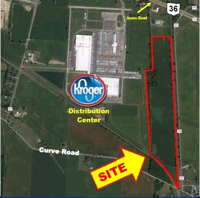
This Property Is For Sale
Property Detail
Curve Rd
Columbus, OH
LAND 18 4 2 M
418-220-01-043-000
DELAWARE
Farms
Ohio
B and X Area of moderate flood hazard, usually the area between the limits of the 100-year and 500-year floods.
53.28 AC
2025
Outlying Delaware County
2025
Columbus
010530
NEARBY LISTINGS FOR SALE OR LEASE
DEMOGRAPHICS near Curve Rd
1 mile
3 mile
5 mile
2025 Total Population
508
18,730
55,917
2030 Population
566
20,726
61,435
Pop Growth 2025-2030
+ 11.42%
+ 10.66%
+ 9.87%
Average Age
42
38
39
2025 Total Households
232
6,996
20,629
HH Growth 2025-2030
+ 11.21%
+ 10.71%
+ 9.87%
Median Household Inc
$87,878
$93,471
$97,395
Avg Household Size
2.10
2.60
2.60
2025 Avg HH Vehicles
2.00
2.00
2.00
Median Home Value
$436,538
$393,777
$370,172
Median Year Built
2004
2001
1995
Nearby Places
Map Layers
Map Styles
 Street
 Aerial
Layers
 Traffic
 Biking
Places
Listings with unknown addresses are not visible on the map
- Restaurants
- Banks
- Shops
- Fitness
- Groceries
PUBLIC TRANSPORTATION
AIRPORT
John Glenn Columbus International
Drive
Walk
Distance
John Glenn Columbus International
39 min
29.8 mi
Freight Ports
Port of Toledo
Drive
Walk
Distance
Port of Toledo
152 min
122.8 mi
Nearby Properties
Address
Land Use
TOTAL SIZE
Lot Size
Zoning
Address
Land Use
TOTAL SIZE
Lot Size
Zoning
349,949 SF
22.53 AC
Address
Land Use
TOTAL SIZE
Lot Size
Zoning
4,324 SF
23.28 AC
Address
Land Use
TOTAL SIZE
Lot Size
Zoning
300,207 SF
32.52 AC
Address
Land Use
TOTAL SIZE
Lot Size
Zoning
5.93 AC
Address
Land Use
TOTAL SIZE
Lot Size
Zoning
153,481 SF
44.98 AC
Address
Land Use
TOTAL SIZE
Lot Size
Zoning
941,795 SF
162.29 AC
Address
Land Use
TOTAL SIZE
Lot Size
Zoning
78,668 SF
9.73 AC
Address
Land Use
TOTAL SIZE
Lot Size
Zoning
110,793 SF
54.70 AC
Address
Land Use
TOTAL SIZE
Lot Size
Zoning
132,673 SF
17.75 AC
Address
Land Use
TOTAL SIZE
Lot Size
Zoning
39,600 SF
15.70 AC
Address
Land Use
TOTAL SIZE
Lot Size
Zoning
41,368 SF
22 AC
Address
Land Use
TOTAL SIZE
Lot Size
Zoning
110,664 SF
13.84 AC
Address
Land Use
TOTAL SIZE
Lot Size
Zoning
52,848 SF
10.63 AC
Address
Land Use
TOTAL SIZE
Lot Size
Zoning
165,091 SF
25.06 AC
Address
Land Use
TOTAL SIZE
Lot Size
Zoning
105,099 SF
3.73 AC
Address
Land Use
TOTAL SIZE
Lot Size
Zoning
68,358 SF
21.55 AC
Address
Land Use
TOTAL SIZE
Lot Size
Zoning
41,838 SF
9.71 AC
Address
Land Use
TOTAL SIZE
Lot Size
Zoning
65,476 SF
26.68 AC
Address
Land Use
TOTAL SIZE
Lot Size
Zoning
5,593 SF
17.78 AC
Address
Land Use
TOTAL SIZE
Lot Size
Zoning
55,040 SF
2.20 AC
Address
Land Use
TOTAL SIZE
Lot Size
Zoning
191,612 SF
18.53 AC
Address
Land Use
TOTAL SIZE
Lot Size
Zoning
66,628 SF
2.63 AC
Address
Land Use
TOTAL SIZE
Lot Size
Zoning
103,740 SF
10 AC
Address
Land Use
TOTAL SIZE
Lot Size
Zoning
75,790 SF
4.71 AC
Address
Land Use
TOTAL SIZE
Lot Size
Zoning
29,690 SF
5.98 AC
Address
Land Use
TOTAL SIZE
Lot Size
Zoning
75,988 SF
1 AC
Address
Land Use
TOTAL SIZE
Lot Size
Zoning
24,018 SF
3.10 AC
Address
Land Use
TOTAL SIZE
Lot Size
Zoning
47,203 SF
0.63 AC
Address
Land Use
TOTAL SIZE
Lot Size
Zoning
34,665 SF
10.29 AC
Address
Land Use
TOTAL SIZE
Lot Size
Zoning
107,395 SF
11.09 AC
The World's #1 Commercial Real Estate Marketplace
Connect with us
© 2026 CoStar Group
The information above has been obtained from sources believed reliable. While we do not doubt its accuracy we have not verified it and make no guarantee, warranty or representation about it. It is your responsibility to independently confirm its accuracy and completeness. Any projections, opinions, assumptions, or estimates used are for example only and do not represent the current or future performance of the property. The value of this transaction to you depends on tax and other factors which should be evaluated by your tax, financial, and legal advisors. You and your advisors should conduct a careful, independent investigation of the property to determine to your satisfaction the suitability of the property for your needs.