Property Record
D4/21 Vac Vic Ave, Lancaster, CA 93536

Save to a Folder
{{folder.Name}}
{{folder.ListingIds.length}} Properties
{{folder.ListingIds.length}} Property
Create a New Folder
Property Detail
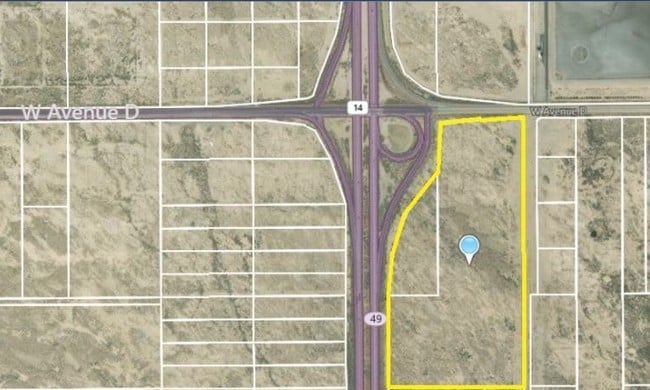
D4/21 Vac Vic Ave
Los Angeles-Long Beach-Glendale, CA
LOT COM AT INTERSECTION OF W LINE OF 20TH ST W WITH N LINE OF S 1/2 OF SE 1/4 OF NE 1/4 OF SEC 20 T 8N R 12W TH N ON SD W LINE AND W ON S LINE OF AVE D TO E LINE OF ANTELOPE VALLEY FRWY TH S E 1/2 OF NE 1/4 OF SEC 20 T 8N R 12W
3116-008-072
LOS ANGELES
Desertorbarrenland
California
LCD22*
20
B and X Area of moderate flood hazard, usually the area between the limits of the 100-year and 500-year floods.
5.10 AC
2025
Antelope Valley
2025
Los Angeles
901214
NEARBY LISTINGS FOR SALE OR LEASE
DEMOGRAPHICS near D4/21 Vac Vic Ave
1 mile
3 mile
5 mile
2025 Total Population
17
1,046
15,605
2030 Population
18
1,134
15,529
Pop Growth 2025-2030
+ 5.88%
+ 8.41%
(0.49%)
Average Age
59
54
37
2025 Total Households
9
513
4,873
HH Growth 2025-2030
+ 11.11%
+ 8.97%
(0.21%)
Median Household Inc
$42,500
$45,192
$57,612
Avg Household Size
1.60
2.00
3.10
2025 Avg HH Vehicles
1.00
1.00
2.00
Median Home Value
$125,000
$127,778
$351,030
Median Year Built
1987
1988
1985
Nearby Places
Map Layers
Map Styles
 Street
 Aerial
Layers
 Traffic
 Biking
Places
Listings with unknown addresses are not visible on the map
- Restaurants
- Banks
- Shops
- Fitness
- Groceries
PUBLIC TRANSPORTATION
COMMUTER RAIL
Lancaster (Antelope Valley Line - Southern California Regional Rail Authority (Metrolink))
Drive
Walk
Distance
Lancaster (Antelope Valley Line - Southern California Regional Rail Authority (Metrolink))
10 min
7.0 mi
Freight Ports
Port of Long Beach
Drive
Walk
Distance
Port of Long Beach
115 min
99.4 mi
SALE & LEASE HISTORY
LISTING DATE
SALE/LEASE

Apr 16, 2019
For Sale
Nearby Properties
Address
Land Use
TOTAL SIZE
Lot Size
Zoning
Address
Land Use
TOTAL SIZE
Lot Size
Zoning
Address
Land Use
TOTAL SIZE
Lot Size
Zoning
37.45 AC
LRSP
Address
Land Use
TOTAL SIZE
Lot Size
Zoning
Address
Land Use
TOTAL SIZE
Lot Size
Zoning
58.68 AC
LCD22*
Address
Land Use
TOTAL SIZE
Lot Size
Zoning
Address
Land Use
TOTAL SIZE
Lot Size
Zoning
57.24 AC
LCD22*
Address
Land Use
TOTAL SIZE
Lot Size
Zoning
81.54 AC
LCD22*
Address
Land Use
TOTAL SIZE
Lot Size
Zoning
77.36 AC
LCD22*
Address
Land Use
TOTAL SIZE
Lot Size
Zoning
32.84 AC
LCD22*
Address
Land Use
TOTAL SIZE
Lot Size
Zoning
26.32 AC
LCM1
Address
Land Use
TOTAL SIZE
Lot Size
Zoning
17.50 AC
LCD21*
Address
Land Use
TOTAL SIZE
Lot Size
Zoning
35.05 AC
LCD21*
Address
Land Use
TOTAL SIZE
Lot Size
Zoning
37.01 AC
LRA12*
Address
Land Use
TOTAL SIZE
Lot Size
Zoning
60 SF
29.74 AC
LCA22*
Address
Land Use
TOTAL SIZE
Lot Size
Zoning
39.96 AC
LCD22*
Address
Land Use
TOTAL SIZE
Lot Size
Zoning
4,540 SF
4.76 AC
LRA12*
Address
Land Use
TOTAL SIZE
Lot Size
Zoning
79.05 AC
LCD22*
Address
Land Use
TOTAL SIZE
Lot Size
Zoning
9.74 AC
LCA22*
Address
Land Use
TOTAL SIZE
Lot Size
Zoning
38.95 AC
LCD22*
Address
Land Use
TOTAL SIZE
Lot Size
Zoning
154.58 AC
LCD22*
Address
Land Use
TOTAL SIZE
Lot Size
Zoning
20.24 AC
LRSP
Address
Land Use
TOTAL SIZE
Lot Size
Zoning
39.24 AC
LCD22*
Address
Land Use
TOTAL SIZE
Lot Size
Zoning
17.97 AC
LRA12*
Address
Land Use
TOTAL SIZE
Lot Size
Zoning
377.35 AC
LCD22*
Address
Land Use
TOTAL SIZE
Lot Size
Zoning
19.59 AC
LCD22*
Address
Land Use
TOTAL SIZE
Lot Size
Zoning
19.47 AC
LCA22*
Address
Land Use
TOTAL SIZE
Lot Size
Zoning
38.48 AC
LRA12*
Address
Land Use
TOTAL SIZE
Lot Size
Zoning
40.79 AC
LCD22*
Address
Land Use
TOTAL SIZE
Lot Size
Zoning
39.22 AC
LCD22*
Address
Land Use
TOTAL SIZE
Lot Size
Zoning
18.11 AC
LRSP
The World's #1 Commercial Real Estate Marketplace
Connect with us
© 2026 CoStar Group
The information above has been obtained from sources believed reliable. While we do not doubt its accuracy we have not verified it and make no guarantee, warranty or representation about it. It is your responsibility to independently confirm its accuracy and completeness. Any projections, opinions, assumptions, or estimates used are for example only and do not represent the current or future performance of the property. The value of this transaction to you depends on tax and other factors which should be evaluated by your tax, financial, and legal advisors. You and your advisors should conduct a careful, independent investigation of the property to determine to your satisfaction the suitability of the property for your needs.