Property Record
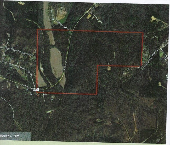
Daffron Rd, Cottondale, AL 35453


Property Detail
Daffron Rd
Tuscaloosa, AL
ALL E1/2 SW1/4 AND N1/2 SE1/4 AND W3/4 SW1/4 SE1/4 SEC 23- TP 22- R9 LESS & EXCEPT DAFFORN LANE, 80' R.O.W. & LESS & EXCEPT 6
37-06-23-0-001-008.000
TUSCALOOSA
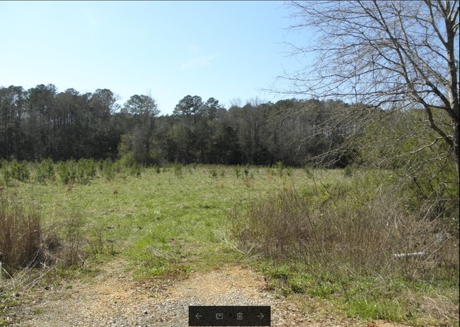
Timberlandforesttreesagricultural
Alabama
A Areas with a 1% annual chance of flooding and a 26% chance of flooding over the life of a 30-year mortgage.
165 AC
2025
Tuscaloosa
2025
Birmingham
010706
NEARBY LISTINGS FOR SALE OR LEASE
-
-
View all Cottondale listings for sale on LoopNet.com
DEMOGRAPHICS near Daffron Rd
1 mile
3 mile
5 mile
2025 Total Population
469
6,872
20,084
2030 Population
481
7,002
20,326
Pop Growth 2025-2030
+ 2.56%
+ 1.89%
+ 1.20%
Average Age
41
41
40
2025 Total Households
182
2,730
8,235
HH Growth 2025-2030
+ 2.75%
+ 2.27%
+ 1.35%
Median Household Inc
$68,863
$74,560
$67,709
Avg Household Size
2.50
2.50
2.40
2025 Avg HH Vehicles
2.00
2.00
2.00
Median Home Value
$173,529
$221,148
$228,441
Median Year Built
1990
1994
1992
Nearby Places
Map Layers
Map Styles
 Street
 Aerial
Layers
 Traffic
 Biking
Places
Listings with unknown addresses are not visible on the map
- Restaurants
- Banks
- Shops
- Fitness
- Groceries
PUBLIC TRANSPORTATION
COMMUTER RAIL
Tuscaloosa Amtrak Station (Crescent - Amtrak)
Drive
Walk
Distance
Tuscaloosa Amtrak Station (Crescent - Amtrak)
15 min
9.6 mi
Freight Ports
Port of Mobile
Drive
Walk
Distance
Port of Mobile
245 min
197.5 mi
SALE & LEASE HISTORY
LISTING DATE
SALE/LEASE

Mar 27, 2018
For Sale
Jul 06, 2022
For Sale
Nearby Properties
Address
Land Use
TOTAL SIZE
Lot Size
Zoning
Address
Land Use
TOTAL SIZE
Lot Size
Zoning
32,020 SF
19.70 AC
Address
Land Use
TOTAL SIZE
Lot Size
Zoning
35,200 SF
33 AC
Address
Land Use
TOTAL SIZE
Lot Size
Zoning
7,412 SF
3.82 AC
Address
Land Use
TOTAL SIZE
Lot Size
Zoning
14,000 SF
3 AC
Address
Land Use
TOTAL SIZE
Lot Size
Zoning
25,352 SF
1.58 AC
Address
Land Use
TOTAL SIZE
Lot Size
Zoning
3,440 SF
25.84 AC
Address
Land Use
TOTAL SIZE
Lot Size
Zoning
16,000 SF
50.78 AC
Address
Land Use
TOTAL SIZE
Lot Size
Zoning
10,488 SF
1.31 AC
Address
Land Use
TOTAL SIZE
Lot Size
Zoning
9,267 SF
0.95 AC
Address
Land Use
TOTAL SIZE
Lot Size
Zoning
9,000 SF
7.40 AC
Address
Land Use
TOTAL SIZE
Lot Size
Zoning
20,120 SF
8 AC
Address
Land Use
TOTAL SIZE
Lot Size
Zoning
8,450 SF
1.20 AC
Address
Land Use
TOTAL SIZE
Lot Size
Zoning
3,600 SF
3.10 AC
Address
Land Use
TOTAL SIZE
Lot Size
Zoning
3,150 SF
1.90 AC
Address
Land Use
TOTAL SIZE
Lot Size
Zoning
10,000 SF
3.90 AC
Address
Land Use
TOTAL SIZE
Lot Size
Zoning
5,234 SF
6.40 AC
Address
Land Use
TOTAL SIZE
Lot Size
Zoning
8,016 SF
15 AC
Address
Land Use
TOTAL SIZE
Lot Size
Zoning
11,250 SF
4.80 AC
Address
Land Use
TOTAL SIZE
Lot Size
Zoning
7,200 SF
0.76 AC
Address
Land Use
TOTAL SIZE
Lot Size
Zoning
6,000 SF
4.91 AC
Address
Land Use
TOTAL SIZE
Lot Size
Zoning
2,400 SF
1.49 AC
Address
Land Use
TOTAL SIZE
Lot Size
Zoning
Address
Land Use
TOTAL SIZE
Lot Size
Zoning
Address
Land Use
TOTAL SIZE
Lot Size
Zoning
1,440 SF
4.70 AC
Address
Land Use
TOTAL SIZE
Lot Size
Zoning
9,600 SF
2.61 AC
Address
Land Use
TOTAL SIZE
Lot Size
Zoning
5,000 SF
1.47 AC
Address
Land Use
TOTAL SIZE
Lot Size
Zoning
Address
Land Use
TOTAL SIZE
Lot Size
Zoning
Address
Land Use
TOTAL SIZE
Lot Size
Zoning
6,000 SF
0.50 AC
Address
Land Use
TOTAL SIZE
Lot Size
Zoning
3,200 SF
1.03 AC
The World's #1 Commercial Real Estate Marketplace
Connect with us
© 2026 CoStar Group
The information above has been obtained from sources believed reliable. While we do not doubt its accuracy we have not verified it and make no guarantee, warranty or representation about it. It is your responsibility to independently confirm its accuracy and completeness. Any projections, opinions, assumptions, or estimates used are for example only and do not represent the current or future performance of the property. The value of this transaction to you depends on tax and other factors which should be evaluated by your tax, financial, and legal advisors. You and your advisors should conduct a careful, independent investigation of the property to determine to your satisfaction the suitability of the property for your needs.