Property Record
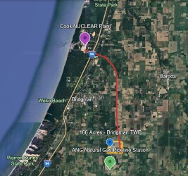
Date Rd, Bridgman, MI 49106

This Property Is For Sale
Property Detail
Date Rd
11-11-0028-0008-02-1
THE NE1/4 OF NW1/4 SEC 33 T6S R19W
Agriculturalland
BERRIEN
R-AG
Michigan
A Areas with a 1% annual chance of flooding and a 26% chance of flooding over the life of a 30-year mortgage.
76.50 AC
2025
Michigan Southwest Area
2026
Other Market Areas
011102
Niles, MI
NEARBY LISTINGS FOR SALE OR LEASE
-
-
View all Bridgman listings for sale on LoopNet.com
DEMOGRAPHICS near Date Rd
1 mile
3 mile
5 mile
2025 Total Population
211
5,904
11,051
2030 Population
210
5,914
11,123
Pop Growth 2025-2030
(0.47%)
+ 0.17%
+ 0.65%
Average Age
43
44
46
2025 Total Households
83
2,433
4,746
HH Growth 2025-2030
(1.20%)
+ 0.16%
+ 0.78%
Median Household Inc
$69,642
$68,107
$72,252
Avg Household Size
2.50
2.40
2.30
2025 Avg HH Vehicles
2.00
2.00
2.00
Median Home Value
$240,909
$240,614
$262,976
Median Year Built
1989
1973
1976
Nearby Places
Map Layers
Map Styles
 Street
 Aerial
Layers
 Traffic
 Biking
Places
Listings with unknown addresses are not visible on the map
- Restaurants
- Banks
- Shops
- Fitness
- Groceries
PUBLIC TRANSPORTATION
AIRPORT
South Bend International
Drive
Walk
Distance
South Bend International
54 min
29.3 mi
Freight Ports
Port Milwaukee
Drive
Walk
Distance
Port Milwaukee
213 min
171.2 mi
Nearby Properties
Address
Land Use
TOTAL SIZE
Lot Size
Zoning
Address
Land Use
TOTAL SIZE
Lot Size
Zoning
252.46 AC
OS
Address
Land Use
TOTAL SIZE
Lot Size
Zoning
41,534 SF
4.75 AC
CC
Address
Land Use
TOTAL SIZE
Lot Size
Zoning
3,520 SF
39.55 AC
R-3
Address
Land Use
TOTAL SIZE
Lot Size
Zoning
2,805 SF
747.96 AC
AG
Address
Land Use
TOTAL SIZE
Lot Size
Zoning
29.91 AC
R-3
Address
Land Use
TOTAL SIZE
Lot Size
Zoning
144,370 SF
13.88 AC
TI
Address
Land Use
TOTAL SIZE
Lot Size
Zoning
95,372 SF
7.87 AC
TI
Address
Land Use
TOTAL SIZE
Lot Size
Zoning
19,585 SF
2.53 AC
CG
Address
Land Use
TOTAL SIZE
Lot Size
Zoning
26,692 SF
15 AC
Address
Land Use
TOTAL SIZE
Lot Size
Zoning
48,972 SF
5.36 AC
C-1
Address
Land Use
TOTAL SIZE
Lot Size
Zoning
1,200 SF
34.49 AC
R4 MOBI
Address
Land Use
TOTAL SIZE
Lot Size
Zoning
1,728 SF
78.82 AC
R-AG
Address
Land Use
TOTAL SIZE
Lot Size
Zoning
10,600 SF
Address
Land Use
TOTAL SIZE
Lot Size
Zoning
4,440 SF
1.50 AC
IG
Address
Land Use
TOTAL SIZE
Lot Size
Zoning
15,947 SF
28.57 AC
RC
Address
Land Use
TOTAL SIZE
Lot Size
Zoning
64,310 SF
10.40 AC
TI
Address
Land Use
TOTAL SIZE
Lot Size
Zoning
268.77 AC
RE
Address
Land Use
TOTAL SIZE
Lot Size
Zoning
2,424 SF
177.68 AC
AG
Address
Land Use
TOTAL SIZE
Lot Size
Zoning
10,376 SF
40 AC
688700
Address
Land Use
TOTAL SIZE
Lot Size
Zoning
42,656 SF
3.05 AC
DE
Address
Land Use
TOTAL SIZE
Lot Size
Zoning
124,327 SF
12.50 AC
Address
Land Use
TOTAL SIZE
Lot Size
Zoning
51,550 SF
4.52 AC
TI
Address
Land Use
TOTAL SIZE
Lot Size
Zoning
4,346 SF
88.69 AC
C-1
Address
Land Use
TOTAL SIZE
Lot Size
Zoning
4,298 SF
40 AC
AG
Address
Land Use
TOTAL SIZE
Lot Size
Zoning
4,262 SF
85 AC
AG
Address
Land Use
TOTAL SIZE
Lot Size
Zoning
3,280 SF
2.22 AC
IG
Address
Land Use
TOTAL SIZE
Lot Size
Zoning
52,320 SF
7.86 AC
TI
Address
Land Use
TOTAL SIZE
Lot Size
Zoning
12,960 SF
0.96 AC
DE
Address
Land Use
TOTAL SIZE
Lot Size
Zoning
2,738 SF
54.95 AC
AG
Address
Land Use
TOTAL SIZE
Lot Size
Zoning
29,780 SF
2.19 AC
DE
The World's #1 Commercial Real Estate Marketplace
Connect with us
© 2026 CoStar Group
The information above has been obtained from sources believed reliable. While we do not doubt its accuracy we have not verified it and make no guarantee, warranty or representation about it. It is your responsibility to independently confirm its accuracy and completeness. Any projections, opinions, assumptions, or estimates used are for example only and do not represent the current or future performance of the property. The value of this transaction to you depends on tax and other factors which should be evaluated by your tax, financial, and legal advisors. You and your advisors should conduct a careful, independent investigation of the property to determine to your satisfaction the suitability of the property for your needs.