Property Record
David Ln, Sandown, NH 03873
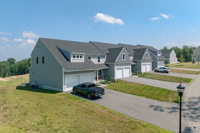
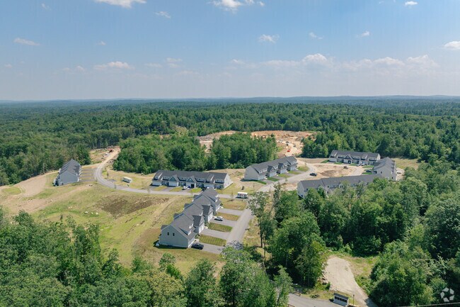
Property Detail
David Ln
SDWN-000016-000009
ROCKINGHAM
Taxexempt
New Hampshire
R
141
B and X Area of moderate flood hazard, usually the area between the limits of the 100-year and 500-year floods.
45.06 AC
2025
Suburban Rockingham County
2025
Boston
052000
Boston-Cambridge-Newton, MA-NH
NEARBY LISTINGS FOR SALE OR LEASE
-
-
View all Sandown listings for sale on LoopNet.com
DEMOGRAPHICS near David Ln
1 mile
3 mile
5 mile
2025 Total Population
790
10,456
32,145
2030 Population
800
10,573
32,359
Pop Growth 2025-2030
+ 1.27%
+ 1.12%
+ 0.67%
Average Age
42
43
43
2025 Total Households
288
3,866
12,059
HH Growth 2025-2030
+ 1.04%
+ 1.01%
+ 0.51%
Median Household Inc
$122,580
$133,519
$120,585
Avg Household Size
2.70
2.70
2.60
2025 Avg HH Vehicles
2.00
3.00
2.00
Median Home Value
$441,525
$457,220
$486,240
Median Year Built
1987
1987
1985
Nearby Places
Map Layers
Map Styles
 Street
 Aerial
Layers
 Traffic
 Biking
Places
Listings with unknown addresses are not visible on the map
- Restaurants
- Banks
- Shops
- Fitness
- Groceries
PUBLIC TRANSPORTATION
AIRPORT
Manchester Boston Regional
Drive
Walk
Distance
Manchester Boston Regional
50 min
20.6 mi
Portsmouth International at Pease
Drive
Walk
Distance
Portsmouth International at Pease
57 min
30.3 mi
Freight Ports
Port of Boston
Drive
Walk
Distance
Port of Boston
77 min
50.1 mi
Nearby Properties
Address
Land Use
TOTAL SIZE
Lot Size
Zoning
Address
Land Use
TOTAL SIZE
Lot Size
Zoning
1,691 SF
112.47 AC
D-MHPM
Address
Land Use
TOTAL SIZE
Lot Size
Zoning
52,901 SF
15 AC
DVDVIL
Address
Land Use
TOTAL SIZE
Lot Size
Zoning
7,590 SF
15.50 AC
R
Address
Land Use
TOTAL SIZE
Lot Size
Zoning
14,866 SF
6.55 AC
R
Address
Land Use
TOTAL SIZE
Lot Size
Zoning
724 SF
R
Address
Land Use
TOTAL SIZE
Lot Size
Zoning
33,798 SF
6 AC
R
Address
Land Use
TOTAL SIZE
Lot Size
Zoning
21.16 AC
RURAL
Address
Land Use
TOTAL SIZE
Lot Size
Zoning
9,328 SF
1.56 AC
B1
Address
Land Use
TOTAL SIZE
Lot Size
Zoning
1,131 SF
123.09 AC
RURAL
Address
Land Use
TOTAL SIZE
Lot Size
Zoning
3.13 AC
Address
Land Use
TOTAL SIZE
Lot Size
Zoning
7,200 SF
5.38 AC
Address
Land Use
TOTAL SIZE
Lot Size
Zoning
9,258 SF
13.67 AC
R
Address
Land Use
TOTAL SIZE
Lot Size
Zoning
6,184 SF
6.04 AC
Address
Land Use
TOTAL SIZE
Lot Size
Zoning
6,480 SF
7.46 AC
Address
Land Use
TOTAL SIZE
Lot Size
Zoning
6,000 SF
24.91 AC
Address
Land Use
TOTAL SIZE
Lot Size
Zoning
100.37 AC
RD RE
Address
Land Use
TOTAL SIZE
Lot Size
Zoning
6,760 SF
5.05 AC
Address
Land Use
TOTAL SIZE
Lot Size
Zoning
231 SF
53 AC
RURAL
Address
Land Use
TOTAL SIZE
Lot Size
Zoning
6,000 SF
5.58 AC
Address
Land Use
TOTAL SIZE
Lot Size
Zoning
2,295 SF
16.09 AC
DVDVIL
Address
Land Use
TOTAL SIZE
Lot Size
Zoning
6,000 SF
3.90 AC
Address
Land Use
TOTAL SIZE
Lot Size
Zoning
1,010 SF
1.19 AC
B-RES
Address
Land Use
TOTAL SIZE
Lot Size
Zoning
12,710 SF
1.82 AC
C3 C
Address
Land Use
TOTAL SIZE
Lot Size
Zoning
6,760 SF
5.05 AC
Address
Land Use
TOTAL SIZE
Lot Size
Zoning
7,200 SF
2.48 AC
C3 C
Address
Land Use
TOTAL SIZE
Lot Size
Zoning
6,116 SF
5 AC
R
Address
Land Use
TOTAL SIZE
Lot Size
Zoning
43.75 AC
Address
Land Use
TOTAL SIZE
Lot Size
Zoning
5,328 SF
4.59 AC
Address
Land Use
TOTAL SIZE
Lot Size
Zoning
9,210 SF
5 AC
R
Address
Land Use
TOTAL SIZE
Lot Size
Zoning
10,260 SF
2.89 AC
C3 C
The World's #1 Commercial Real Estate Marketplace
Connect with us
© 2026 CoStar Group
The information above has been obtained from sources believed reliable. While we do not doubt its accuracy we have not verified it and make no guarantee, warranty or representation about it. It is your responsibility to independently confirm its accuracy and completeness. Any projections, opinions, assumptions, or estimates used are for example only and do not represent the current or future performance of the property. The value of this transaction to you depends on tax and other factors which should be evaluated by your tax, financial, and legal advisors. You and your advisors should conduct a careful, independent investigation of the property to determine to your satisfaction the suitability of the property for your needs.