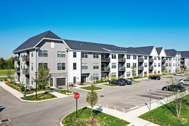
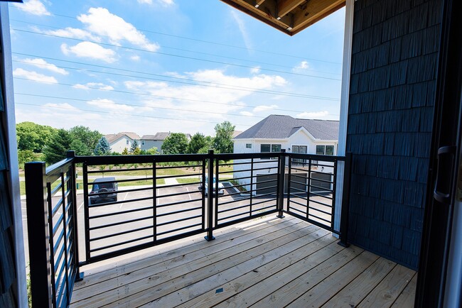
Property Record
Davidson Rd, Hilliard, OH 43026


Property Detail
Davidson Rd
050-011419
4178 DAVIDSON ROAD OQ 600 ENTRY 4854 14.134 ACRES
Apartment
FRANKLIN
B and X Area of moderate flood hazard, usually the area between the limits of the 100-year and 500-year floods.
Ohio
2024
14.13 AC
2025
Outer Upper Arlington
007955
Columbus
195,867 SF
Columbus, OH
NEARBY LISTINGS FOR SALE OR LEASE
DEMOGRAPHICS near Davidson Rd
1 mile
3 mile
5 mile
2025 Total Population
11,584
95,366
217,778
2030 Population
11,880
97,746
223,155
Pop Growth 2025-2030
+ 2.56%
+ 2.50%
+ 2.47%
Average Age
39
39
39
2025 Total Households
5,156
41,237
91,789
HH Growth 2025-2030
+ 2.44%
+ 2.57%
+ 2.60%
Median Household Inc
$108,201
$94,911
$99,122
Avg Household Size
2.20
2.30
2.30
2025 Avg HH Vehicles
2.00
2.00
2.00
Median Home Value
$410,587
$365,970
$388,804
Median Year Built
1995
1991
1990
Nearby Places
Map Layers
Map Styles
 Street
 Aerial
Layers
 Traffic
 Biking
Places
Listings with unknown addresses are not visible on the map
- Restaurants
- Banks
- Shops
- Fitness
- Groceries
PUBLIC TRANSPORTATION
AIRPORT
John Glenn Columbus International
Drive
Walk
Distance
John Glenn Columbus International
29 min
20.1 mi
Rickenbacker International
Drive
Walk
Distance
Rickenbacker International
34 min
24.8 mi
Freight Ports
Port of Toledo
Drive
Walk
Distance
Port of Toledo
177 min
128.6 mi
Nearby Properties
Address
Land Use
TOTAL SIZE
Lot Size
Zoning
Address
Land Use
TOTAL SIZE
Lot Size
Zoning
182,845 SF
325.61 AC
Address
Land Use
TOTAL SIZE
Lot Size
Zoning
768,498 SF
55.17 AC
Address
Land Use
TOTAL SIZE
Lot Size
Zoning
880,352 SF
94.89 AC
Address
Land Use
TOTAL SIZE
Lot Size
Zoning
327,525 SF
70.58 AC
Address
Land Use
TOTAL SIZE
Lot Size
Zoning
529,001 SF
0.15 AC
Address
Land Use
TOTAL SIZE
Lot Size
Zoning
419,285 SF
17.19 AC
Address
Land Use
TOTAL SIZE
Lot Size
Zoning
260,092 SF
29.05 AC
Address
Land Use
TOTAL SIZE
Lot Size
Zoning
549,907 SF
35.81 AC
Address
Land Use
TOTAL SIZE
Lot Size
Zoning
133,910 SF
14.48 AC
Address
Land Use
TOTAL SIZE
Lot Size
Zoning
158,471 SF
19.11 AC
Address
Land Use
TOTAL SIZE
Lot Size
Zoning
46,231 SF
27.42 AC
Address
Land Use
TOTAL SIZE
Lot Size
Zoning
91,413 SF
0.14 AC
Address
Land Use
TOTAL SIZE
Lot Size
Zoning
557,021 SF
21.28 AC
Address
Land Use
TOTAL SIZE
Lot Size
Zoning
160,958 SF
11.93 AC
Address
Land Use
TOTAL SIZE
Lot Size
Zoning
47,334 SF
29.34 AC
Address
Land Use
TOTAL SIZE
Lot Size
Zoning
110,180 SF
29.07 AC
Address
Land Use
TOTAL SIZE
Lot Size
Zoning
82,510 SF
15.80 AC
Address
Land Use
TOTAL SIZE
Lot Size
Zoning
446,488 SF
45.12 AC
Address
Land Use
TOTAL SIZE
Lot Size
Zoning
163,895 SF
36.52 AC
Address
Land Use
TOTAL SIZE
Lot Size
Zoning
276,379 SF
14.75 AC
Address
Land Use
TOTAL SIZE
Lot Size
Zoning
67,186 SF
21.51 AC
Address
Land Use
TOTAL SIZE
Lot Size
Zoning
414,372 SF
24.87 AC
Address
Land Use
TOTAL SIZE
Lot Size
Zoning
216,795 SF
10.21 AC
Address
Land Use
TOTAL SIZE
Lot Size
Zoning
226,566 SF
14.88 AC
Address
Land Use
TOTAL SIZE
Lot Size
Zoning
105,351 SF
9.88 AC
Address
Land Use
TOTAL SIZE
Lot Size
Zoning
98,316 SF
10.81 AC
Address
Land Use
TOTAL SIZE
Lot Size
Zoning
156,030 SF
31.29 AC
Address
Land Use
TOTAL SIZE
Lot Size
Zoning
73,944 SF
11.03 AC
Address
Land Use
TOTAL SIZE
Lot Size
Zoning
115,392 SF
25 AC
The World's #1 Commercial Real Estate Marketplace
Connect with us
© 2026 CoStar Group
The information above has been obtained from sources believed reliable. While we do not doubt its accuracy we have not verified it and make no guarantee, warranty or representation about it. It is your responsibility to independently confirm its accuracy and completeness. Any projections, opinions, assumptions, or estimates used are for example only and do not represent the current or future performance of the property. The value of this transaction to you depends on tax and other factors which should be evaluated by your tax, financial, and legal advisors. You and your advisors should conduct a careful, independent investigation of the property to determine to your satisfaction the suitability of the property for your needs.