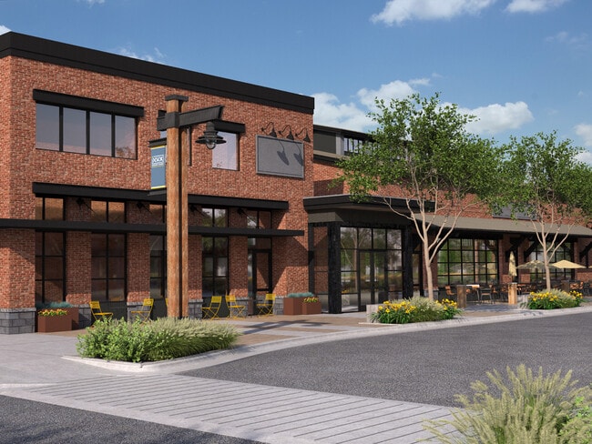
Property Record
4801 Harvest Pkwy, Bozeman, MT 59718


NEARBY LISTINGS FOR SALE OR LEASE
Property Detail
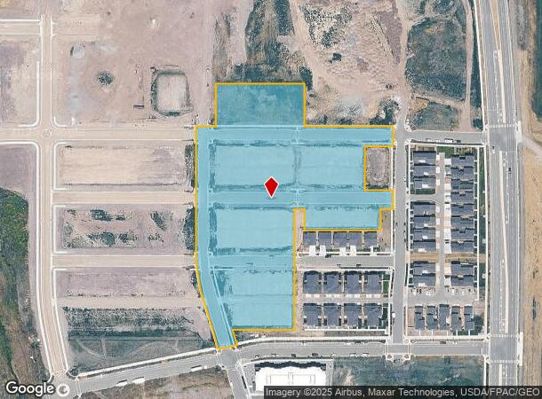
4801 Harvest Pkwy
06-0798-04-1-01-01-0000
Northwest Crossing Sub Ph 2.1
Agriculturalland
NORTHWEST CROSSING SUB PH 2.1, S04, T02 S, R05 E, LOT RESTRICTED 1A-1, ACRES 7.09, PER PLAT J-736-A
X
Gallatin
30031C0803D
Montana
2025
7.09 AC
2025
Bozeman/Yellowstone Country
000506
Other Market Areas
2,314 SF
Bozeman, MT
DEMOGRAPHICS near 4801 Harvest Pkwy
1 Mile
3 Mile
5 Mile
2024 Total Population
8,639
48,040
84,468
2029 Population
10,695
58,506
102,204
Pop Growth 2024-2029
+ 23.80%
+ 21.79%
+ 21.00%
Average Age
34
35
37
2024 Total Households
3,532
20,054
34,607
HH Growth 2024-2029
+ 25.34%
+ 23.78%
+ 23.28%
Median Household Inc
$86,279
$74,492
$81,887
Avg Household Size
2.40
2.30
2.30
2024 Avg HH Vehicles
2.00
2.00
2.00
Median Home Value
$411,667
$467,731
$593,567
Median Year Built
2010
2010
2005
Nearby Places
Map Layers
Map Styles
 Street
 Aerial
- Restaurants
- Banks
- Shops
- Fitness
- Groceries
PUBLIC TRANSPORTATION
AIRPORT
Bozeman Yellowstone International
DRIVE
WALK
Distance
Bozeman Yellowstone International
19 min
10.8 mi
Freight Ports
Port of Everett
DRIVE
WALK
Distance
Port of Everett
749 min
701.2 mi
SALE & LEASE HISTORY
LISTING DATE
SALE/LEASE

May 30, 2025
For Lease
Apr 12, 2021
For Lease
Nearby Properties
Address
Land Use
TOTAL SIZE
Lot Size
Zoning
Address
Land Use
TOTAL SIZE
Lot Size
Zoning
138,308 SF
58.03 AC
Address
Land Use
TOTAL SIZE
Lot Size
Zoning
33,109 SF
9.89 AC
Address
Land Use
TOTAL SIZE
Lot Size
Zoning
214,283 SF
5.20 AC
Address
Land Use
TOTAL SIZE
Lot Size
Zoning
6,317 SF
9.14 AC
Address
Land Use
TOTAL SIZE
Lot Size
Zoning
69,093 SF
8.96 AC
BP
Address
Land Use
TOTAL SIZE
Lot Size
Zoning
129,579 SF
9.74 AC
Address
Land Use
TOTAL SIZE
Lot Size
Zoning
10,368 SF
6.75 AC
Address
Land Use
TOTAL SIZE
Lot Size
Zoning
33,771 SF
7.10 AC
Address
Land Use
TOTAL SIZE
Lot Size
Zoning
81,620 SF
10.65 AC
1
Address
Land Use
TOTAL SIZE
Lot Size
Zoning
259,349 SF
B2
Address
Land Use
TOTAL SIZE
Lot Size
Zoning
20,106 SF
8.23 AC
Address
Land Use
TOTAL SIZE
Lot Size
Zoning
149,599 SF
18.41 AC
Address
Land Use
TOTAL SIZE
Lot Size
Zoning
119,732 SF
7.32 AC
Address
Land Use
TOTAL SIZE
Lot Size
Zoning
19,938 SF
Address
Land Use
TOTAL SIZE
Lot Size
Zoning
27,219 SF
10.11 AC
R3
Address
Land Use
TOTAL SIZE
Lot Size
Zoning
128,745 SF
4.24 AC
Address
Land Use
TOTAL SIZE
Lot Size
Zoning
41,864 SF
16.37 AC
1
Address
Land Use
TOTAL SIZE
Lot Size
Zoning
59,860 SF
42.94 AC
Address
Land Use
TOTAL SIZE
Lot Size
Zoning
94,146 SF
7.18 AC
R3
Address
Land Use
TOTAL SIZE
Lot Size
Zoning
122,580 SF
10.85 AC
Address
Land Use
TOTAL SIZE
Lot Size
Zoning
173,255 SF
3.26 AC
Address
Land Use
TOTAL SIZE
Lot Size
Zoning
84,649 SF
Address
Land Use
TOTAL SIZE
Lot Size
Zoning
93,211 SF
4.24 AC
Address
Land Use
TOTAL SIZE
Lot Size
Zoning
47,466 SF
25.72 AC
Address
Land Use
TOTAL SIZE
Lot Size
Zoning
21,858 SF
5.48 AC
RO
Address
Land Use
TOTAL SIZE
Lot Size
Zoning
35,325 SF
77.53 AC
Address
Land Use
TOTAL SIZE
Lot Size
Zoning
5,870 SF
4.41 AC
Address
Land Use
TOTAL SIZE
Lot Size
Zoning
20,940 SF
9.97 AC
Address
Land Use
TOTAL SIZE
Lot Size
Zoning
85,204 SF
3.05 AC
Address
Land Use
TOTAL SIZE
Lot Size
Zoning
70,684 SF
5.15 AC
The World's #1 Commercial Real Estate Marketplace
Connect with us
© 2025 CoStar Group
The information above has been obtained from sources believed reliable. While we do not doubt its accuracy we have not verified it and make no guarantee, warranty or representation about it. It is your responsibility to independently confirm its accuracy and completeness. Any projections, opinions, assumptions, or estimates used are for example only and do not represent the current or future performance of the property. The value of this transaction to you depends on tax and other factors which should be evaluated by your tax, financial, and legal advisors. You and your advisors should conduct a careful, independent investigation of the property to determine to your satisfaction the suitability of the property for your needs.