Property Record
Del Oro Rd, Apple Valley, CA 92307


Property Detail
Del Oro Rd
Riverside-San Bernardino-Ontario, CA
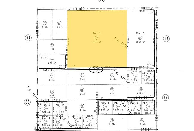
PARCEL MAP 2289 PARCEL 1 EX CO RDS
3080-091-05
SAN BERNARDINO
Vacantlandnec
California
D Areas with possible but undetermined flood hazards.
37.81 AC
2025
Mojave River Valley
2025
Inland Empire (California)
009714
NEARBY LISTINGS FOR SALE OR LEASE
DEMOGRAPHICS near Del Oro Rd
1 mile
3 mile
5 mile
2025 Total Population
2,046
27,123
59,669
2030 Population
2,078
27,542
60,414
Pop Growth 2025-2030
+ 1.56%
+ 1.54%
+ 1.25%
Average Age
39
37
41
2025 Total Households
687
8,835
20,527
HH Growth 2025-2030
+ 1.60%
+ 1.56%
+ 1.22%
Median Household Inc
$54,000
$61,495
$71,041
Avg Household Size
2.90
3.00
2.80
2025 Avg HH Vehicles
2.00
2.00
2.00
Median Home Value
$309,600
$372,645
$402,082
Median Year Built
1985
1985
1987
Nearby Places
Map Layers
Map Styles
 Street
 Aerial
Layers
 Traffic
 Biking
Places
Listings with unknown addresses are not visible on the map
- Restaurants
- Banks
- Shops
- Fitness
- Groceries
SALE & LEASE HISTORY
LISTING DATE
SALE/LEASE

Sep 24, 2016
For Sale
Nearby Properties
Address
Land Use
TOTAL SIZE
Lot Size
Zoning
Address
Land Use
TOTAL SIZE
Lot Size
Zoning
116,365 SF
8.93 AC
Address
Land Use
TOTAL SIZE
Lot Size
Zoning
18,800 SF
2.60 AC
Address
Land Use
TOTAL SIZE
Lot Size
Zoning
75,280 SF
4.07 AC
Address
Land Use
TOTAL SIZE
Lot Size
Zoning
35,178 SF
3.44 AC
Address
Land Use
TOTAL SIZE
Lot Size
Zoning
86,148 SF
5.38 AC
Address
Land Use
TOTAL SIZE
Lot Size
Zoning
4,998 SF
2.76 AC
Address
Land Use
TOTAL SIZE
Lot Size
Zoning
53,972 SF
4.80 AC
Address
Land Use
TOTAL SIZE
Lot Size
Zoning
37,521 SF
24.52 AC
Address
Land Use
TOTAL SIZE
Lot Size
Zoning
8,970 SF
0.78 AC
Address
Land Use
TOTAL SIZE
Lot Size
Zoning
6,572 SF
1.26 AC
Address
Land Use
TOTAL SIZE
Lot Size
Zoning
15,885 SF
4.38 AC
Address
Land Use
TOTAL SIZE
Lot Size
Zoning
870 SF
0.79 AC
Address
Land Use
TOTAL SIZE
Lot Size
Zoning
15,740 SF
4.23 AC
Address
Land Use
TOTAL SIZE
Lot Size
Zoning
12,320 SF
0.92 AC
Address
Land Use
TOTAL SIZE
Lot Size
Zoning
21,050 SF
1.45 AC
Address
Land Use
TOTAL SIZE
Lot Size
Zoning
28,200 SF
2.50 AC
Address
Land Use
TOTAL SIZE
Lot Size
Zoning
9,239 SF
1.28 AC
Address
Land Use
TOTAL SIZE
Lot Size
Zoning
12,505 SF
4.84 AC
Address
Land Use
TOTAL SIZE
Lot Size
Zoning
31,524 SF
2.94 AC
Address
Land Use
TOTAL SIZE
Lot Size
Zoning
19,590 SF
2.19 AC
Address
Land Use
TOTAL SIZE
Lot Size
Zoning
19,140 SF
1.84 AC
Address
Land Use
TOTAL SIZE
Lot Size
Zoning
12,483 SF
1.80 AC
Address
Land Use
TOTAL SIZE
Lot Size
Zoning
13,000 SF
0.96 AC
Address
Land Use
TOTAL SIZE
Lot Size
Zoning
2,730 SF
0.53 AC
Address
Land Use
TOTAL SIZE
Lot Size
Zoning
11,240 SF
1.17 AC
Address
Land Use
TOTAL SIZE
Lot Size
Zoning
7,000 SF
0.99 AC
Address
Land Use
TOTAL SIZE
Lot Size
Zoning
3,134 SF
0.77 AC
Address
Land Use
TOTAL SIZE
Lot Size
Zoning
20,401 SF
1.52 AC
Address
Land Use
TOTAL SIZE
Lot Size
Zoning
41,200 SF
2.75 AC
Address
Land Use
TOTAL SIZE
Lot Size
Zoning
8,400 SF
1.36 AC
The World's #1 Commercial Real Estate Marketplace
Connect with us
© 2026 CoStar Group
The information above has been obtained from sources believed reliable. While we do not doubt its accuracy we have not verified it and make no guarantee, warranty or representation about it. It is your responsibility to independently confirm its accuracy and completeness. Any projections, opinions, assumptions, or estimates used are for example only and do not represent the current or future performance of the property. The value of this transaction to you depends on tax and other factors which should be evaluated by your tax, financial, and legal advisors. You and your advisors should conduct a careful, independent investigation of the property to determine to your satisfaction the suitability of the property for your needs.