Property Record
6Th Paper St, Deltona, FL 32725
This Property Is For Sale
NEARBY LISTINGS FOR SALE OR LEASE
Property Detail
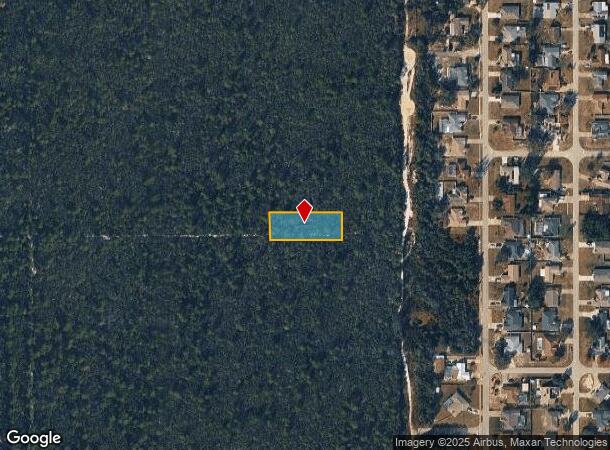
6Th Paper St
Deltona-Daytona Beach-Ormond Beach, FL
Pine View Ests Mb
8108-01-06-0110
LOTS 11 THRU 20 BLK 6 ADD PINE VIEW ESTS MB 9 PG 173 PER OR 2533 PG 0403 PER OR 7224 PGS 2873-2874 PER OR 8609 PG 4088 PER OR 8717 PG 4727
Commercialacreage
Volusia
X
Florida
12127C0640K
11-20
2025
0.57 AC
2026
Deltona
091016
Deltona/Daytona Beach
DEMOGRAPHICS near 6Th Paper St
1 Mile
3 Mile
5 Mile
2024 Total Population
5,749
50,117
141,238
2029 Population
6,850
59,856
169,011
Pop Growth 2024-2029
+ 19.15%
+ 19.43%
+ 19.66%
Average Age
42
42
42
2024 Total Households
1,996
18,739
53,040
HH Growth 2024-2029
+ 19.04%
+ 19.52%
+ 19.80%
Median Household Inc
$77,064
$63,945
$65,912
Avg Household Size
2.70
2.60
2.60
2024 Avg HH Vehicles
2.00
2.00
2.00
Median Home Value
$227,419
$220,480
$232,305
Median Year Built
1986
1987
1989
Nearby Places
Map Layers
Map Styles
 Street
 Aerial
- Restaurants
- Banks
- Shops
- Fitness
- Groceries
PUBLIC TRANSPORTATION
AIRPORT
Orlando Sanford International
DRIVE
WALK
Distance
Orlando Sanford International
34 min
20.6 mi
Daytona Beach International
DRIVE
WALK
Distance
Daytona Beach International
32 min
23.3 mi
Freight Ports
Port Canaveral
DRIVE
WALK
Distance
Port Canaveral
94 min
78.4 mi
Nearby Properties
Address
Land Use
TOTAL SIZE
Lot Size
Zoning
Address
Land Use
TOTAL SIZE
Lot Size
Zoning
485,392 SF
69.83 AC
ROW
Address
Land Use
TOTAL SIZE
Lot Size
Zoning
986,415 SF
56.11 AC
Address
Land Use
TOTAL SIZE
Lot Size
Zoning
1,337,979 SF
85.14 AC
01I2
Address
Land Use
TOTAL SIZE
Lot Size
Zoning
613,629 SF
630 AC
P
Address
Land Use
TOTAL SIZE
Lot Size
Zoning
204,239 SF
31.36 AC
Address
Land Use
TOTAL SIZE
Lot Size
Zoning
423,073 SF
12.48 AC
Address
Land Use
TOTAL SIZE
Lot Size
Zoning
689,978 SF
39.89 AC
RRC
Address
Land Use
TOTAL SIZE
Lot Size
Zoning
369,949 SF
13.70 AC
Address
Land Use
TOTAL SIZE
Lot Size
Zoning
390,347 SF
4.10 AC
Address
Land Use
TOTAL SIZE
Lot Size
Zoning
352,859 SF
16 AC
R4C2
Address
Land Use
TOTAL SIZE
Lot Size
Zoning
255,327 SF
28.64 AC
Address
Land Use
TOTAL SIZE
Lot Size
Zoning
339,508 SF
72.75 AC
01A3
Address
Land Use
TOTAL SIZE
Lot Size
Zoning
221,429 SF
25.84 AC
Address
Land Use
TOTAL SIZE
Lot Size
Zoning
121,380 SF
2.33 AC
Address
Land Use
TOTAL SIZE
Lot Size
Zoning
50,005 SF
5.60 AC
Address
Land Use
TOTAL SIZE
Lot Size
Zoning
170,850 SF
17.82 AC
Address
Land Use
TOTAL SIZE
Lot Size
Zoning
33,371 SF
12.86 AC
Address
Land Use
TOTAL SIZE
Lot Size
Zoning
213,506 SF
21 AC
12R2
Address
Land Use
TOTAL SIZE
Lot Size
Zoning
5,195 SF
55.08 AC
A3
Address
Land Use
TOTAL SIZE
Lot Size
Zoning
123,193 SF
20 AC
01A3
Address
Land Use
TOTAL SIZE
Lot Size
Zoning
4,684 SF
1.14 AC
12MH1
Address
Land Use
TOTAL SIZE
Lot Size
Zoning
139,919 SF
7.20 AC
MPUD
Address
Land Use
TOTAL SIZE
Lot Size
Zoning
9,421 SF
7 AC
Address
Land Use
TOTAL SIZE
Lot Size
Zoning
100,345 SF
19.70 AC
Address
Land Use
TOTAL SIZE
Lot Size
Zoning
147,759 SF
19.64 AC
Address
Land Use
TOTAL SIZE
Lot Size
Zoning
113,782 SF
18.52 AC
P
Address
Land Use
TOTAL SIZE
Lot Size
Zoning
214,666 SF
9 AC
Address
Land Use
TOTAL SIZE
Lot Size
Zoning
115,271 SF
17.08 AC
R4
Address
Land Use
TOTAL SIZE
Lot Size
Zoning
28.62 AC
01A1
Address
Land Use
TOTAL SIZE
Lot Size
Zoning
43,178 SF
4.23 AC
C1
The World's #1 Commercial Real Estate Marketplace
Connect with us
© 2026 CoStar Group
The information above has been obtained from sources believed reliable. While we do not doubt its accuracy we have not verified it and make no guarantee, warranty or representation about it. It is your responsibility to independently confirm its accuracy and completeness. Any projections, opinions, assumptions, or estimates used are for example only and do not represent the current or future performance of the property. The value of this transaction to you depends on tax and other factors which should be evaluated by your tax, financial, and legal advisors. You and your advisors should conduct a careful, independent investigation of the property to determine to your satisfaction the suitability of the property for your needs.