Property Record
Dennard Rd Ne, Conyers, GA 30013


Property Detail
Dennard Rd Ne
Atlanta-Sandy Springs-Roswell, GA
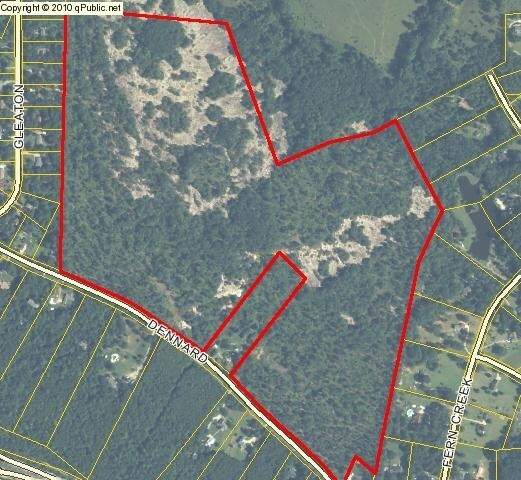
&LL 373 NE/SIDE DENNARD RD
087-0-01-0003
ROCKDALE
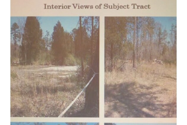
Privatepreserveopenspacevacantlandforestlandconservation
Georgia
R1/COND
373
B and X Area of moderate flood hazard, usually the area between the limits of the 100-year and 500-year floods.
111.85 AC
2025
I-20 East/Conyers
2025
Atlanta
060312
NEARBY LISTINGS FOR SALE OR LEASE
DEMOGRAPHICS near Dennard Rd Ne
1 mile
3 mile
5 mile
2025 Total Population
1,767
15,127
48,168
2030 Population
1,845
15,984
50,927
Pop Growth 2025-2030
+ 4.41%
+ 5.67%
+ 5.73%
Average Age
38
40
39
2025 Total Households
620
5,354
17,300
HH Growth 2025-2030
+ 4.68%
+ 5.85%
+ 5.94%
Median Household Inc
$91,666
$84,057
$75,809
Avg Household Size
2.80
2.70
2.70
2025 Avg HH Vehicles
2.00
2.00
2.00
Median Home Value
$309,756
$302,042
$294,647
Median Year Built
1994
1995
1991
Nearby Places
Map Layers
Map Styles
 Street
 Aerial
Layers
 Traffic
 Biking
Places
Listings with unknown addresses are not visible on the map
- Restaurants
- Banks
- Shops
- Fitness
- Groceries
PUBLIC TRANSPORTATION
AIRPORT
Hartsfield - Jackson Atlanta International
Drive
Walk
Distance
Hartsfield - Jackson Atlanta International
47 min
33.6 mi
Freight Ports
Georgia Ports - Savannah
Drive
Walk
Distance
Georgia Ports - Savannah
284 min
242.5 mi
Nearby Properties
Address
Land Use
TOTAL SIZE
Lot Size
Zoning
Address
Land Use
TOTAL SIZE
Lot Size
Zoning
7,806 SF
32.76 AC
RM
Address
Land Use
TOTAL SIZE
Lot Size
Zoning
3,256 SF
22.05 AC
RM
Address
Land Use
TOTAL SIZE
Lot Size
Zoning
3,066 SF
22.44 AC
R3/R1
Address
Land Use
TOTAL SIZE
Lot Size
Zoning
3,648 SF
26.50 AC
R3/R1
Address
Land Use
TOTAL SIZE
Lot Size
Zoning
210,380 SF
15.86 AC
ID
Address
Land Use
TOTAL SIZE
Lot Size
Zoning
5,902 SF
903.52 AC
RES AG
Address
Land Use
TOTAL SIZE
Lot Size
Zoning
17,800 SF
11.36 AC
RM/C
Address
Land Use
TOTAL SIZE
Lot Size
Zoning
180,890 SF
45.15 AC
R1
Address
Land Use
TOTAL SIZE
Lot Size
Zoning
205,716 SF
22.88 AC
ID
Address
Land Use
TOTAL SIZE
Lot Size
Zoning
201,089 SF
13.40 AC
ID
Address
Land Use
TOTAL SIZE
Lot Size
Zoning
28,012 SF
4.04 AC
OI
Address
Land Use
TOTAL SIZE
Lot Size
Zoning
180,000 SF
12.37 AC
ID
Address
Land Use
TOTAL SIZE
Lot Size
Zoning
174,720 SF
13.54 AC
ID
Address
Land Use
TOTAL SIZE
Lot Size
Zoning
286.57 AC
RES AG
Address
Land Use
TOTAL SIZE
Lot Size
Zoning
100,800 SF
9 AC
ID
Address
Land Use
TOTAL SIZE
Lot Size
Zoning
89,384 SF
19.92 AC
ID
Address
Land Use
TOTAL SIZE
Lot Size
Zoning
225,000 SF
23.50 AC
ID
Address
Land Use
TOTAL SIZE
Lot Size
Zoning
122,500 SF
11.30 AC
ID
Address
Land Use
TOTAL SIZE
Lot Size
Zoning
71.95 AC
R1
Address
Land Use
TOTAL SIZE
Lot Size
Zoning
148,000 SF
10.42 AC
ID
Address
Land Use
TOTAL SIZE
Lot Size
Zoning
74,724 SF
5.54 AC
ID
Address
Land Use
TOTAL SIZE
Lot Size
Zoning
121,592 SF
23.05 AC
ID/C
Address
Land Use
TOTAL SIZE
Lot Size
Zoning
80,000 SF
13.62 AC
ID
Address
Land Use
TOTAL SIZE
Lot Size
Zoning
15,606 SF
10.69 AC
ID
Address
Land Use
TOTAL SIZE
Lot Size
Zoning
59,829 SF
5.72 AC
ID
Address
Land Use
TOTAL SIZE
Lot Size
Zoning
149,760 SF
16.39 AC
ID
Address
Land Use
TOTAL SIZE
Lot Size
Zoning
57,417 SF
11.25 AC
BN
Address
Land Use
TOTAL SIZE
Lot Size
Zoning
66,181 SF
25.46 AC
R1A
Address
Land Use
TOTAL SIZE
Lot Size
Zoning
179,005 SF
15.60 AC
ID
Address
Land Use
TOTAL SIZE
Lot Size
Zoning
36,140 SF
2.74 AC
OI
The World's #1 Commercial Real Estate Marketplace
Connect with us
© 2026 CoStar Group
The information above has been obtained from sources believed reliable. While we do not doubt its accuracy we have not verified it and make no guarantee, warranty or representation about it. It is your responsibility to independently confirm its accuracy and completeness. Any projections, opinions, assumptions, or estimates used are for example only and do not represent the current or future performance of the property. The value of this transaction to you depends on tax and other factors which should be evaluated by your tax, financial, and legal advisors. You and your advisors should conduct a careful, independent investigation of the property to determine to your satisfaction the suitability of the property for your needs.