Property Record
Derende St, Winston Salem, NC 27107
This Property Is For Sale
NEARBY LISTINGS FOR SALE OR LEASE
Property Detail
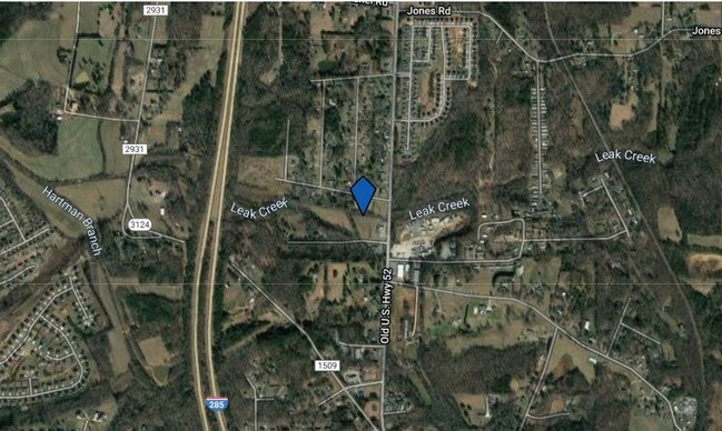
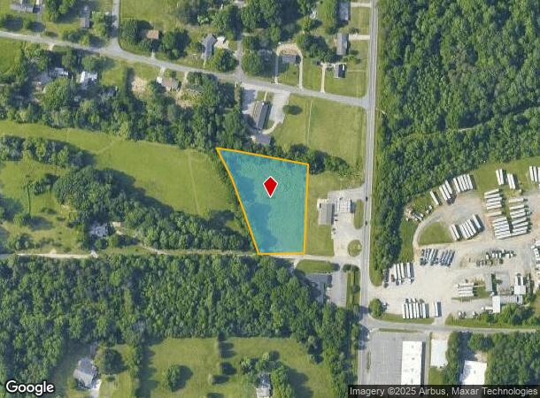
Derende St
Winston-Salem, NC
Ptic & South Main St
6832-50-8368
LO:205E BL:2710
Residentialacreage
Forsyth
AE
North Carolina
3710683200J
205e
2024
1.85 AC
2025
South Forsyth County
003500
Greensboro/Winston-Salem
DEMOGRAPHICS near Derende St
1 Mile
3 Mile
5 Mile
2024 Total Population
2,285
24,061
72,669
2029 Population
2,395
25,217
75,763
Pop Growth 2024-2029
+ 4.81%
+ 4.80%
+ 4.26%
Average Age
40
40
39
2024 Total Households
908
9,652
28,754
HH Growth 2024-2029
+ 4.74%
+ 4.72%
+ 4.23%
Median Household Inc
$67,202
$64,864
$57,409
Avg Household Size
2.40
2.40
2.50
2024 Avg HH Vehicles
2.00
2.00
2.00
Median Home Value
$188,967
$185,094
$177,194
Median Year Built
2001
1997
1990
Nearby Places
- Restaurants
- Banks
- Shops
- Fitness
- Groceries
PUBLIC TRANSPORTATION
AIRPORT
Piedmont Triad International
DRIVE
WALK
Distance
Piedmont Triad International
37 min
24.5 mi
Freight Ports
Port of Wilmington
DRIVE
WALK
Distance
Port of Wilmington
275 min
233.2 mi
Nearby Properties
Address
Land Use
TOTAL SIZE
Lot Size
Zoning
Address
Land Use
TOTAL SIZE
Lot Size
Zoning
211,658 SF
27.33 AC
MRB-S
Address
Land Use
TOTAL SIZE
Lot Size
Zoning
79,734 SF
22.54 AC
RM12-S
Address
Land Use
TOTAL SIZE
Lot Size
Zoning
57,837 SF
9.45 AC
RM18-S
Address
Land Use
TOTAL SIZE
Lot Size
Zoning
48,620 SF
15.51 AC
RM12-S
Address
Land Use
TOTAL SIZE
Lot Size
Zoning
992,551 SF
72.46 AC
GI
Address
Land Use
TOTAL SIZE
Lot Size
Zoning
139,248 SF
27.24 AC
MRB-S
Address
Land Use
TOTAL SIZE
Lot Size
Zoning
77,143 SF
12.09 AC
NSB-S
Address
Land Use
TOTAL SIZE
Lot Size
Zoning
469,797 SF
73.87 AC
GI
Address
Land Use
TOTAL SIZE
Lot Size
Zoning
87,041 SF
44 AC
RA3
Address
Land Use
TOTAL SIZE
Lot Size
Zoning
77,048 SF
7.76 AC
HC
Address
Land Use
TOTAL SIZE
Lot Size
Zoning
48,831 SF
2.83 AC
GB-S
Address
Land Use
TOTAL SIZE
Lot Size
Zoning
35,395 SF
3.72 AC
MRB-S
Address
Land Use
TOTAL SIZE
Lot Size
Zoning
199,441 SF
7.08 AC
LI
Address
Land Use
TOTAL SIZE
Lot Size
Zoning
58,597 SF
63.22 AC
GI
Address
Land Use
TOTAL SIZE
Lot Size
Zoning
10,416 SF
7.25 AC
PDH
Address
Land Use
TOTAL SIZE
Lot Size
Zoning
36,917 SF
11.10 AC
RM8-S
Address
Land Use
TOTAL SIZE
Lot Size
Zoning
79,586 SF
8.99 AC
CS
Address
Land Use
TOTAL SIZE
Lot Size
Zoning
82,020 SF
6.18 AC
RM12-S
Address
Land Use
TOTAL SIZE
Lot Size
Zoning
16,334 SF
1.88 AC
HC
Address
Land Use
TOTAL SIZE
Lot Size
Zoning
35,869 SF
3.44 AC
IP
Address
Land Use
TOTAL SIZE
Lot Size
Zoning
28,442 SF
18.06 AC
RA3
Address
Land Use
TOTAL SIZE
Lot Size
Zoning
24,909 SF
5.32 AC
RM18
Address
Land Use
TOTAL SIZE
Lot Size
Zoning
13,607 SF
1.39 AC
MRB-S
Address
Land Use
TOTAL SIZE
Lot Size
Zoning
6,544 SF
1.73 AC
MRB-S
Address
Land Use
TOTAL SIZE
Lot Size
Zoning
4,752 SF
1.47 AC
MRB-S
Address
Land Use
TOTAL SIZE
Lot Size
Zoning
16,648 SF
10.23 AC
GB,HB
Address
Land Use
TOTAL SIZE
Lot Size
Zoning
20,172 SF
2.41 AC
PDHC
Address
Land Use
TOTAL SIZE
Lot Size
Zoning
4,000 SF
9.35 AC
HC
Address
Land Use
TOTAL SIZE
Lot Size
Zoning
7,281 SF
HI
Address
Land Use
TOTAL SIZE
Lot Size
Zoning
53,934 SF
7.49 AC
CS
The World's #1 Commercial Real Estate Marketplace
Connect with us
© 2025 CoStar Group
The information above has been obtained from sources believed reliable. While we do not doubt its accuracy we have not verified it and make no guarantee, warranty or representation about it. It is your responsibility to independently confirm its accuracy and completeness. Any projections, opinions, assumptions, or estimates used are for example only and do not represent the current or future performance of the property. The value of this transaction to you depends on tax and other factors which should be evaluated by your tax, financial, and legal advisors. You and your advisors should conduct a careful, independent investigation of the property to determine to your satisfaction the suitability of the property for your needs.