Property Record
Derhammer Pkwy, Paw Paw, MI 49079
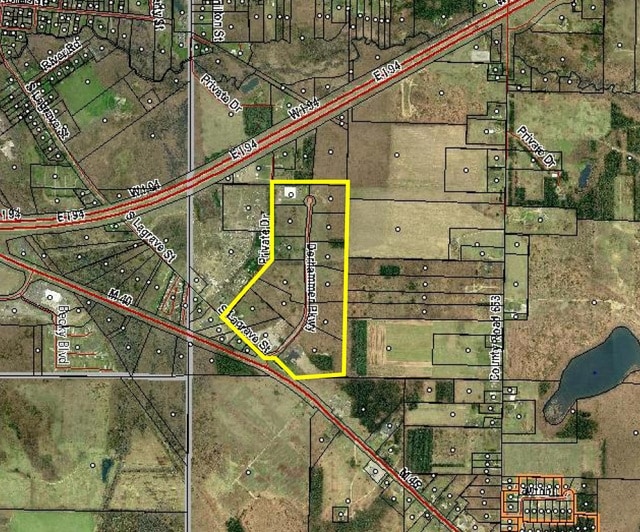
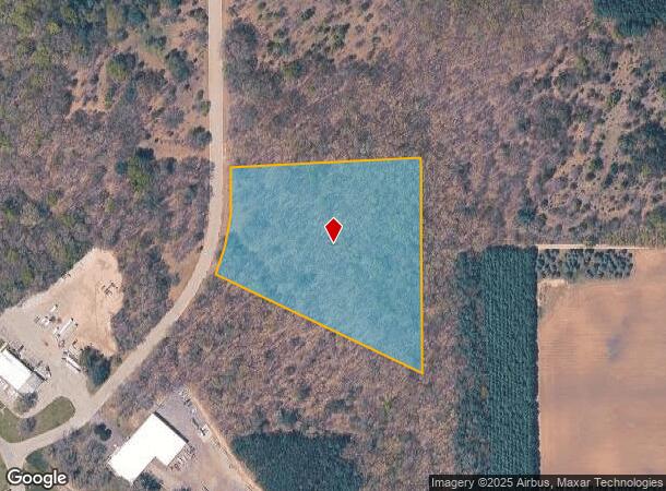

This Property Is For Sale
NEARBY LISTINGS FOR SALE OR LEASE
-
-
View all Paw Paw listings for sale on LoopNet.com
Property Detail
Derhammer Pkwy
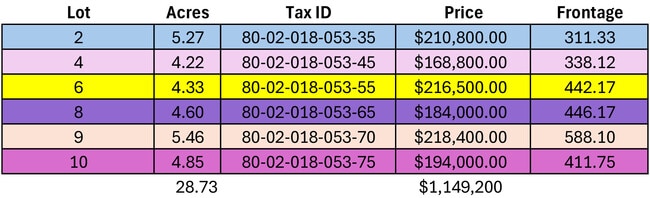
80-02-018-053-35
277-D 18-3-13 1078-273-276 1100-458 1446-391 1661-992 * COM AT S 1/4 POST OF SEC, TH N 89 DEG 54'11"E ALG S SEC L 489.52 FT
Industrialacreage
Van Buren
X
Michigan
26077C0275D
5.27 AC
2024
Van Buren County
2025
West Michigan
011802
Kalamazoo-Portage, MI
DEMOGRAPHICS near Derhammer Pkwy
1 Mile
3 Mile
5 Mile
2024 Total Population
1,101
9,660
18,613
2029 Population
1,082
9,459
18,245
Pop Growth 2024-2029
(1.73%)
(2.08%)
(1.98%)
Average Age
39
40
40
2024 Total Households
429
3,770
7,166
HH Growth 2024-2029
(2.10%)
(2.39%)
(2.25%)
Median Household Inc
$70,499
$72,844
$76,453
Avg Household Size
2.50
2.50
2.50
2024 Avg HH Vehicles
2.00
2.00
2.00
Median Home Value
$167,272
$176,020
$186,194
Median Year Built
1980
1976
1980
Nearby Places
Map Layers
Map Styles
 Street
 Aerial
- Restaurants
- Banks
- Shops
- Fitness
- Groceries
PUBLIC TRANSPORTATION
AIRPORT
Kalamazoo/Battle Creek International
DRIVE
WALK
Distance
Kalamazoo/Battle Creek International
28 min
20.2 mi
Freight Ports
Port Milwaukee
DRIVE
WALK
Distance
Port Milwaukee
252 min
213.3 mi
Nearby Properties
Address
Land Use
TOTAL SIZE
Lot Size
Zoning
Address
Land Use
TOTAL SIZE
Lot Size
Zoning
391,023 SF
19.86 AC
HCI
Address
Land Use
TOTAL SIZE
Lot Size
Zoning
115,552 SF
35.06 AC
HCI
Address
Land Use
TOTAL SIZE
Lot Size
Zoning
96,530 SF
49.22 AC
VILLAGE
Address
Land Use
TOTAL SIZE
Lot Size
Zoning
105,000 SF
7.09 AC
VILLAGE
Address
Land Use
TOTAL SIZE
Lot Size
Zoning
119,245 SF
19.53 AC
VILLAGE
Address
Land Use
TOTAL SIZE
Lot Size
Zoning
57,384 SF
15.40 AC
HCI
Address
Land Use
TOTAL SIZE
Lot Size
Zoning
320,181 SF
6 AC
CALL VILLA
Address
Land Use
TOTAL SIZE
Lot Size
Zoning
46,885 SF
4 AC
CALL VILLA
Address
Land Use
TOTAL SIZE
Lot Size
Zoning
19,200 SF
2.94 AC
VILLAGE
Address
Land Use
TOTAL SIZE
Lot Size
Zoning
108,067 SF
9.22 AC
VILLAGE
Address
Land Use
TOTAL SIZE
Lot Size
Zoning
14,517 SF
10.03 AC
AG
Address
Land Use
TOTAL SIZE
Lot Size
Zoning
28,580 SF
5.51 AC
VILLAGE
Address
Land Use
TOTAL SIZE
Lot Size
Zoning
45,553 SF
5.67 AC
VILLAGE
Address
Land Use
TOTAL SIZE
Lot Size
Zoning
45,124 SF
Address
Land Use
TOTAL SIZE
Lot Size
Zoning
21,632 SF
3.65 AC
VILLAGE
Address
Land Use
TOTAL SIZE
Lot Size
Zoning
21,453 SF
6.62 AC
VILLAGE
Address
Land Use
TOTAL SIZE
Lot Size
Zoning
22,848 SF
2.27 AC
VILLAGE
Address
Land Use
TOTAL SIZE
Lot Size
Zoning
18,920 SF
7.20 AC
VILLAGE
Address
Land Use
TOTAL SIZE
Lot Size
Zoning
22,444 SF
6.75 AC
VILLAGE
Address
Land Use
TOTAL SIZE
Lot Size
Zoning
32.71 AC
VILLAGE
Address
Land Use
TOTAL SIZE
Lot Size
Zoning
27,456 SF
5.09 AC
VILLAGE
Address
Land Use
TOTAL SIZE
Lot Size
Zoning
13,650 SF
1.88 AC
VILLAGE
Address
Land Use
TOTAL SIZE
Lot Size
Zoning
15,000 SF
1.34 AC
VILLAGE
Address
Land Use
TOTAL SIZE
Lot Size
Zoning
2,996 SF
1 AC
AG
Address
Land Use
TOTAL SIZE
Lot Size
Zoning
18.01 AC
VILLAGE
Address
Land Use
TOTAL SIZE
Lot Size
Zoning
41,535 SF
6.35 AC
GC
Address
Land Use
TOTAL SIZE
Lot Size
Zoning
15,840 SF
Address
Land Use
TOTAL SIZE
Lot Size
Zoning
5,868 SF
2.77 AC
VILLAGE
Address
Land Use
TOTAL SIZE
Lot Size
Zoning
18.99 AC
VILLAGE
Address
Land Use
TOTAL SIZE
Lot Size
Zoning
54,446 SF
15.28 AC
VE
The World's #1 Commercial Real Estate Marketplace
Connect with us
© 2026 CoStar Group
The information above has been obtained from sources believed reliable. While we do not doubt its accuracy we have not verified it and make no guarantee, warranty or representation about it. It is your responsibility to independently confirm its accuracy and completeness. Any projections, opinions, assumptions, or estimates used are for example only and do not represent the current or future performance of the property. The value of this transaction to you depends on tax and other factors which should be evaluated by your tax, financial, and legal advisors. You and your advisors should conduct a careful, independent investigation of the property to determine to your satisfaction the suitability of the property for your needs.