Property Record
Devore Rd, Rialto, CA 92376
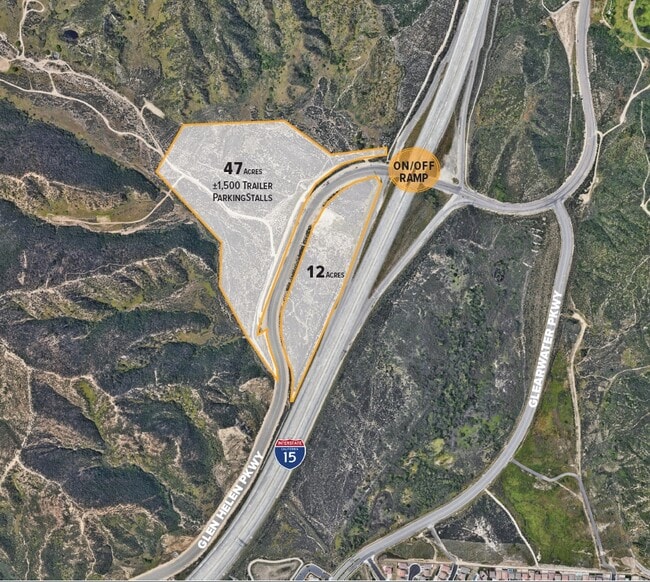
Current Lease Availabilities
Property Detail
Devore Rd
Riverside-San Bernardino-Ontario, CA
S 1/2 GOV LOT 2 AND PTN GOV LOT 5 LYING WLY OF STATE HWY (DEVORE RD) AND NE 1/4 SW 1/4 NE 1/4 AND SE 1/4 NE 1/4 ALL IN SEC 5 TP 1N R 5W EX HWY
0239-031-17
SAN BERNARDINO
Vacantlandnec
California
GHSP
2
B and X Area of moderate flood hazard, usually the area between the limits of the 100-year and 500-year floods.
6.71 AC
2025
San Bernardino
2025
Inland Empire (California)
003700
NEARBY LISTINGS FOR SALE OR LEASE
DEMOGRAPHICS near Devore Rd
1 mile
3 mile
5 mile
2024 Total Population
3,555
19,177
75,286
2029 Population
3,593
19,410
76,458
Pop Growth 2024-2029
+ 1.07%
+ 1.21%
+ 1.56%
Average Age
34
36
36
2024 Total Households
903
5,130
20,168
HH Growth 2024-2029
+ 0.89%
+ 1.19%
+ 1.53%
Median Household Inc
$138,306
$123,811
$116,814
Avg Household Size
3.60
3.60
3.60
2024 Avg HH Vehicles
3.00
3.00
3.00
Median Home Value
$579,618
$517,513
$498,657
Median Year Built
2011
1999
1998
Nearby Places
Map Layers
Map Styles
 Street
 Aerial
Transit
 Traffic
 Biking
Places
Listings with unknown addresses are not visible on the map
- Restaurants
- Banks
- Shops
- Fitness
- Groceries
PUBLIC TRANSPORTATION
COMMUTER RAIL
Fontana (San Bernardino Line - Southern California Regional Rail Authority (Metrolink))
Drive
Walk
Distance
Fontana (San Bernardino Line - Southern California Regional Rail Authority (Metrolink))
12 min
8.2 mi
Rialto (San Bernardino Line - Southern California Regional Rail Authority (Metrolink))
Drive
Walk
Distance
Rialto (San Bernardino Line - Southern California Regional Rail Authority (Metrolink))
15 min
9.9 mi
AIRPORT
Ontario International
Drive
Walk
Distance
Ontario International
21 min
16.4 mi
Freight Ports
Port of Long Beach
Drive
Walk
Distance
Port of Long Beach
83 min
68.5 mi
Nearby Properties
Address
Land Use
TOTAL SIZE
Lot Size
Zoning
Address
Land Use
TOTAL SIZE
Lot Size
Zoning
1,171,788 SF
43.73 AC
Address
Land Use
TOTAL SIZE
Lot Size
Zoning
183,030 SF
62.05 AC
Address
Land Use
TOTAL SIZE
Lot Size
Zoning
805,980 SF
39.57 AC
Address
Land Use
TOTAL SIZE
Lot Size
Zoning
830,613 SF
35.21 AC
Address
Land Use
TOTAL SIZE
Lot Size
Zoning
335,460 SF
16.45 AC
Address
Land Use
TOTAL SIZE
Lot Size
Zoning
730,988 SF
32.09 AC
GHSP
Address
Land Use
TOTAL SIZE
Lot Size
Zoning
671,229 SF
19.50 AC
Address
Land Use
TOTAL SIZE
Lot Size
Zoning
321,496 SF
21.24 AC
Address
Land Use
TOTAL SIZE
Lot Size
Zoning
16.09 AC
GHSP
Address
Land Use
TOTAL SIZE
Lot Size
Zoning
211,703 SF
12.34 AC
Address
Land Use
TOTAL SIZE
Lot Size
Zoning
597,996 SF
29.51 AC
Address
Land Use
TOTAL SIZE
Lot Size
Zoning
10.06 AC
Address
Land Use
TOTAL SIZE
Lot Size
Zoning
103,370 SF
5.07 AC
GHSP
Address
Land Use
TOTAL SIZE
Lot Size
Zoning
254,174 SF
7.05 AC
GHSP
Address
Land Use
TOTAL SIZE
Lot Size
Zoning
124,228 SF
6.44 AC
Address
Land Use
TOTAL SIZE
Lot Size
Zoning
61,724 SF
6 AC
GHSP
Address
Land Use
TOTAL SIZE
Lot Size
Zoning
4.77 AC
Address
Land Use
TOTAL SIZE
Lot Size
Zoning
19.03 AC
Address
Land Use
TOTAL SIZE
Lot Size
Zoning
10.16 AC
Address
Land Use
TOTAL SIZE
Lot Size
Zoning
Address
Land Use
TOTAL SIZE
Lot Size
Zoning
32,000 SF
8.79 AC
Address
Land Use
TOTAL SIZE
Lot Size
Zoning
Address
Land Use
TOTAL SIZE
Lot Size
Zoning
2.60 AC
GHSP
Address
Land Use
TOTAL SIZE
Lot Size
Zoning
81,576 SF
19.31 AC
Address
Land Use
TOTAL SIZE
Lot Size
Zoning
200,000 SF
12.46 AC
Address
Land Use
TOTAL SIZE
Lot Size
Zoning
2.39 AC
Address
Land Use
TOTAL SIZE
Lot Size
Zoning
2.39 AC
The World's #1 Commercial Real Estate Marketplace
Connect with us
© 2026 CoStar Group
The information above has been obtained from sources believed reliable. While we do not doubt its accuracy we have not verified it and make no guarantee, warranty or representation about it. It is your responsibility to independently confirm its accuracy and completeness. Any projections, opinions, assumptions, or estimates used are for example only and do not represent the current or future performance of the property. The value of this transaction to you depends on tax and other factors which should be evaluated by your tax, financial, and legal advisors. You and your advisors should conduct a careful, independent investigation of the property to determine to your satisfaction the suitability of the property for your needs.