Property Record
Dick Cook Rd, Loomis, CA 95650
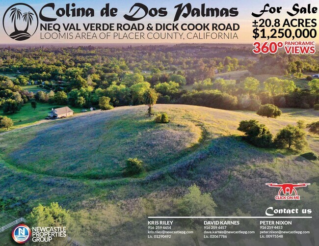

Property Detail
Dick Cook Rd
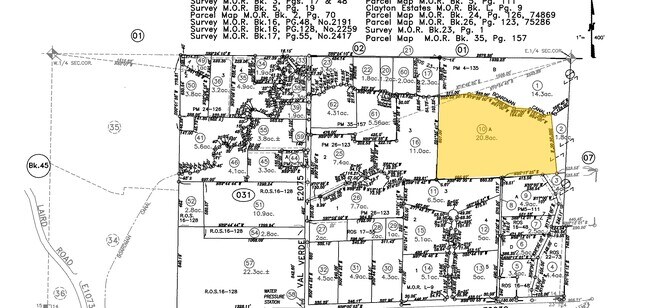
036-031-010
20.9 AC POR PAR A PM 4-135, PAR A WPM 2055-76
Vacantlandnec
PLACER
RABX
California
B and X Area of moderate flood hazard, usually the area between the limits of the 100-year and 500-year floods.
20.90 AC
2024
Roseville/Rocklin
2025
Sacramento
020607
Sacramento-Roseville-Folsom, CA
NEARBY LISTINGS FOR SALE OR LEASE
DEMOGRAPHICS near Dick Cook Rd
1 mile
3 mile
5 mile
2025 Total Population
1,033
18,826
59,094
2030 Population
1,089
19,796
62,008
Pop Growth 2025-2030
+ 5.42%
+ 5.15%
+ 4.93%
Average Age
45
43
43
2025 Total Households
372
6,691
21,666
HH Growth 2025-2030
+ 5.38%
+ 5.16%
+ 4.97%
Median Household Inc
$168,125
$147,801
$131,325
Avg Household Size
2.80
2.80
2.70
2025 Avg HH Vehicles
3.00
2.00
2.00
Median Home Value
$849,999
$858,482
$798,477
Median Year Built
1988
1988
1988
Nearby Places
Map Layers
Map Styles
 Street
 Aerial
Layers
 Traffic
 Biking
Places
Listings with unknown addresses are not visible on the map
- Restaurants
- Banks
- Shops
- Fitness
- Groceries
PUBLIC TRANSPORTATION
COMMUTER RAIL
Rocklin Amtrak Station (Capitol Corridor - Amtrak)
Drive
Walk
Distance
Rocklin Amtrak Station (Capitol Corridor - Amtrak)
13 min
6.3 mi
AIRPORT
Sacramento International
Drive
Walk
Distance
Sacramento International
47 min
34.0 mi
Freight Ports
Port of Stockton
Drive
Walk
Distance
Port of Stockton
90 min
74.2 mi
SALE & LEASE HISTORY
LISTING DATE
SALE/LEASE

Jun 03, 2020
For Sale
Nearby Properties
Address
Land Use
TOTAL SIZE
Lot Size
Zoning
Address
Land Use
TOTAL SIZE
Lot Size
Zoning
182,547 SF
10.19 AC
Address
Land Use
TOTAL SIZE
Lot Size
Zoning
246,349 SF
9.89 AC
Address
Land Use
TOTAL SIZE
Lot Size
Zoning
154,696 SF
10.80 AC
Address
Land Use
TOTAL SIZE
Lot Size
Zoning
194,087 SF
15.82 AC
Address
Land Use
TOTAL SIZE
Lot Size
Zoning
159,029 SF
17.62 AC
Address
Land Use
TOTAL SIZE
Lot Size
Zoning
136,101 SF
10 AC
Address
Land Use
TOTAL SIZE
Lot Size
Zoning
1,992 SF
44.99 AC
RAB100
Address
Land Use
TOTAL SIZE
Lot Size
Zoning
73,756 SF
6.60 AC
Address
Land Use
TOTAL SIZE
Lot Size
Zoning
6,167 SF
12.20 AC
Address
Land Use
TOTAL SIZE
Lot Size
Zoning
100,348 SF
12.50 AC
Address
Land Use
TOTAL SIZE
Lot Size
Zoning
89,928 SF
6 AC
CG
Address
Land Use
TOTAL SIZE
Lot Size
Zoning
48,170 SF
4 AC
Address
Land Use
TOTAL SIZE
Lot Size
Zoning
63,608 SF
5.20 AC
CG
Address
Land Use
TOTAL SIZE
Lot Size
Zoning
34,066 SF
2.90 AC
Address
Land Use
TOTAL SIZE
Lot Size
Zoning
19,604 SF
3.08 AC
Address
Land Use
TOTAL SIZE
Lot Size
Zoning
85,435 SF
2.75 AC
Address
Land Use
TOTAL SIZE
Lot Size
Zoning
20,800 SF
2.10 AC
Address
Land Use
TOTAL SIZE
Lot Size
Zoning
35,146 SF
4 AC
Address
Land Use
TOTAL SIZE
Lot Size
Zoning
25,368 SF
1.08 AC
RH
Address
Land Use
TOTAL SIZE
Lot Size
Zoning
39,825 SF
3.10 AC
Address
Land Use
TOTAL SIZE
Lot Size
Zoning
17,733 SF
1.40 AC
C1UPDC
Address
Land Use
TOTAL SIZE
Lot Size
Zoning
26,750 SF
5.20 AC
CG
Address
Land Use
TOTAL SIZE
Lot Size
Zoning
26,884 SF
1.40 AC
Address
Land Use
TOTAL SIZE
Lot Size
Zoning
25,000 SF
2.40 AC
Address
Land Use
TOTAL SIZE
Lot Size
Zoning
14,410 SF
12.60 AC
Address
Land Use
TOTAL SIZE
Lot Size
Zoning
12,968 SF
1.19 AC
Address
Land Use
TOTAL SIZE
Lot Size
Zoning
12,259 SF
2.60 AC
RE
Address
Land Use
TOTAL SIZE
Lot Size
Zoning
14,834 SF
1.20 AC
Address
Land Use
TOTAL SIZE
Lot Size
Zoning
19,315 SF
2.70 AC
Address
Land Use
TOTAL SIZE
Lot Size
Zoning
10,555 SF
78.63 AC
The World's #1 Commercial Real Estate Marketplace
Connect with us
© 2026 CoStar Group
The information above has been obtained from sources believed reliable. While we do not doubt its accuracy we have not verified it and make no guarantee, warranty or representation about it. It is your responsibility to independently confirm its accuracy and completeness. Any projections, opinions, assumptions, or estimates used are for example only and do not represent the current or future performance of the property. The value of this transaction to you depends on tax and other factors which should be evaluated by your tax, financial, and legal advisors. You and your advisors should conduct a careful, independent investigation of the property to determine to your satisfaction the suitability of the property for your needs.