Property Record
State Route 693, Russell, KY 41169
NEARBY LISTINGS FOR SALE OR LEASE
-
-
View all Russell listings for lease on LoopNet.com
Property Detail
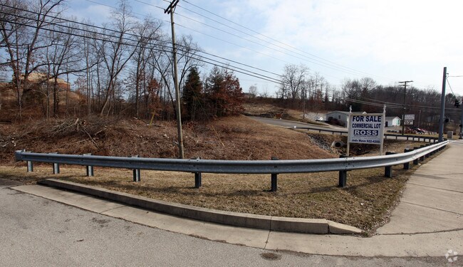
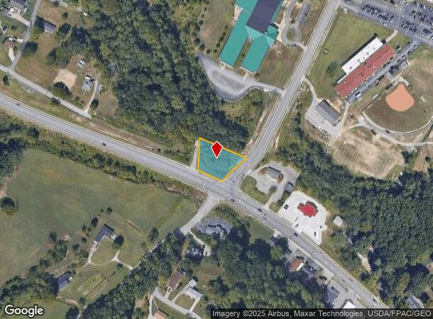
State Route 693
Huntington-Ashland, WV-KY-OH
INTERSECTION .007 AC
183-40-01-002.00
Greenup
Stateproperty
Kentucky
2025
0.01 AC
2025
Greenup County
040201
Huntington/Ashland
DEMOGRAPHICS near State Route 693
1 Mile
3 Mile
5 Mile
2024 Total Population
5,768
28,940
52,835
2029 Population
5,634
28,278
51,781
Pop Growth 2024-2029
(2.32%)
(2.29%)
(1.99%)
Average Age
43
43
42
2024 Total Households
2,363
12,001
21,904
HH Growth 2024-2029
(2.29%)
(2.22%)
(1.94%)
Median Household Inc
$71,313
$54,890
$51,511
Avg Household Size
2.40
2.30
2.30
2024 Avg HH Vehicles
2.00
2.00
2.00
Median Home Value
$144,050
$118,432
$116,602
Median Year Built
1971
1966
1967
Nearby Places
Map Layers
Map Styles
 Street
 Aerial
- Restaurants
- Banks
- Shops
- Fitness
- Groceries
PUBLIC TRANSPORTATION
COMMUTER RAIL
Ashland Amtrak Station (Cardinal - Amtrak)
DRIVE
WALK
Distance
Ashland Amtrak Station (Cardinal - Amtrak)
8 min
4.7 mi
AIRPORT
Tri-State/Milton J Ferguson Field
DRIVE
WALK
Distance
Tri-State/Milton J Ferguson Field
29 min
16.5 mi
Freight Ports
Port of Toledo
DRIVE
WALK
Distance
Port of Toledo
335 min
255.5 mi
SALE & LEASE HISTORY
LISTING DATE
SALE/LEASE

Mar 23, 2023
For Lease
Nearby Properties
Address
Land Use
TOTAL SIZE
Lot Size
Zoning
Address
Land Use
TOTAL SIZE
Lot Size
Zoning
Address
Land Use
TOTAL SIZE
Lot Size
Zoning
3,514 SF
21.96 AC
Z02
Address
Land Use
TOTAL SIZE
Lot Size
Zoning
1.94 AC
Z03
Address
Land Use
TOTAL SIZE
Lot Size
Zoning
Address
Land Use
TOTAL SIZE
Lot Size
Zoning
11.95 AC
Address
Land Use
TOTAL SIZE
Lot Size
Zoning
12.54 AC
Address
Land Use
TOTAL SIZE
Lot Size
Zoning
Address
Land Use
TOTAL SIZE
Lot Size
Zoning
40.94 AC
Address
Land Use
TOTAL SIZE
Lot Size
Zoning
Address
Land Use
TOTAL SIZE
Lot Size
Zoning
1.63 AC
COMMERCIAL
Address
Land Use
TOTAL SIZE
Lot Size
Zoning
Address
Land Use
TOTAL SIZE
Lot Size
Zoning
3.86 AC
Address
Land Use
TOTAL SIZE
Lot Size
Zoning
19.91 AC
Address
Land Use
TOTAL SIZE
Lot Size
Zoning
1,424 SF
6.46 AC
Address
Land Use
TOTAL SIZE
Lot Size
Zoning
139,148 SF
Address
Land Use
TOTAL SIZE
Lot Size
Zoning
Address
Land Use
TOTAL SIZE
Lot Size
Zoning
35,014 SF
3.81 AC
Address
Land Use
TOTAL SIZE
Lot Size
Zoning
9.43 AC
Address
Land Use
TOTAL SIZE
Lot Size
Zoning
30,250 SF
8.29 AC
Address
Land Use
TOTAL SIZE
Lot Size
Zoning
75,820 SF
1.71 AC
Address
Land Use
TOTAL SIZE
Lot Size
Zoning
1,440 SF
1.38 AC
Address
Land Use
TOTAL SIZE
Lot Size
Zoning
9.49 AC
Address
Land Use
TOTAL SIZE
Lot Size
Zoning
47,557 SF
1.69 AC
Address
Land Use
TOTAL SIZE
Lot Size
Zoning
2.50 AC
Address
Land Use
TOTAL SIZE
Lot Size
Zoning
9,300 SF
7.65 AC
Address
Land Use
TOTAL SIZE
Lot Size
Zoning
Address
Land Use
TOTAL SIZE
Lot Size
Zoning
Address
Land Use
TOTAL SIZE
Lot Size
Zoning
5.14 AC
Address
Land Use
TOTAL SIZE
Lot Size
Zoning
5,472 SF
4.94 AC
Address
Land Use
TOTAL SIZE
Lot Size
Zoning
The World's #1 Commercial Real Estate Marketplace
Connect with us
© 2025 CoStar Group
The information above has been obtained from sources believed reliable. While we do not doubt its accuracy we have not verified it and make no guarantee, warranty or representation about it. It is your responsibility to independently confirm its accuracy and completeness. Any projections, opinions, assumptions, or estimates used are for example only and do not represent the current or future performance of the property. The value of this transaction to you depends on tax and other factors which should be evaluated by your tax, financial, and legal advisors. You and your advisors should conduct a careful, independent investigation of the property to determine to your satisfaction the suitability of the property for your needs.