Property Record
Dills Bluff Rd, Charleston, SC 29412

NEARBY LISTINGS FOR SALE OR LEASE
Property Detail
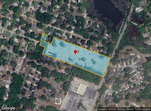
Dills Bluff Rd
Charleston-North Charleston, SC
Whitehouse Plantation
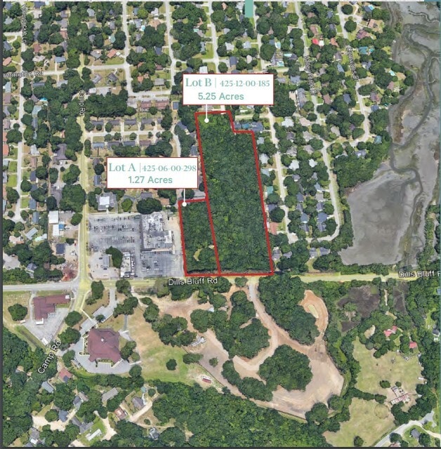
425-12-00-185
SUBDIVISION NAME -WHITEHOUSE PLANTATION DESCRIPTION -LOT B
Residentialacreage
Charleston
AE
South Carolina
45019C0677K
b
2025
5.25 AC
2024
James Island/Folly Beach
002002
Charleston/N Charleston
DEMOGRAPHICS near Dills Bluff Rd
1 Mile
3 Mile
5 Mile
2024 Total Population
8,034
35,390
79,676
2029 Population
8,480
37,613
85,730
Pop Growth 2024-2029
+ 5.55%
+ 6.28%
+ 7.60%
Average Age
40
41
40
2024 Total Households
3,375
15,538
36,021
HH Growth 2024-2029
+ 5.36%
+ 6.24%
+ 7.65%
Median Household Inc
$90,106
$88,037
$80,075
Avg Household Size
2.30
2.20
2.10
2024 Avg HH Vehicles
2.00
2.00
2.00
Median Home Value
$370,777
$392,020
$454,994
Median Year Built
1981
1987
1977
Nearby Places
Map Layers
Map Styles
 Street
 Aerial
- Restaurants
- Banks
- Shops
- Fitness
- Groceries
PUBLIC TRANSPORTATION
AIRPORT
Charleston AFB/International
DRIVE
WALK
Distance
Charleston AFB/International
32 min
18.0 mi
Freight Ports
Columbus Street Terminal
DRIVE
WALK
Distance
Columbus Street Terminal
13 min
7.2 mi
SALE & LEASE HISTORY
LISTING DATE
SALE/LEASE

Sep 26, 2022
For Sale
Jul 15, 2021
For Sale
Nearby Properties
Address
Land Use
TOTAL SIZE
Lot Size
Zoning
Address
Land Use
TOTAL SIZE
Lot Size
Zoning
3,780 SF
14.35 AC
Address
Land Use
TOTAL SIZE
Lot Size
Zoning
14,474 SF
23.53 AC
Address
Land Use
TOTAL SIZE
Lot Size
Zoning
257,500 SF
4.72 AC
Address
Land Use
TOTAL SIZE
Lot Size
Zoning
12,766 SF
1.72 AC
Address
Land Use
TOTAL SIZE
Lot Size
Zoning
Address
Land Use
TOTAL SIZE
Lot Size
Zoning
16,775 SF
5.93 AC
Address
Land Use
TOTAL SIZE
Lot Size
Zoning
Address
Land Use
TOTAL SIZE
Lot Size
Zoning
7,722 SF
20.48 AC
Address
Land Use
TOTAL SIZE
Lot Size
Zoning
3.11 AC
Address
Land Use
TOTAL SIZE
Lot Size
Zoning
Address
Land Use
TOTAL SIZE
Lot Size
Zoning
2,896 SF
18.13 AC
Address
Land Use
TOTAL SIZE
Lot Size
Zoning
65,397 SF
2.46 AC
Address
Land Use
TOTAL SIZE
Lot Size
Zoning
11.80 AC
Address
Land Use
TOTAL SIZE
Lot Size
Zoning
5,988 SF
10 AC
Address
Land Use
TOTAL SIZE
Lot Size
Zoning
7.46 AC
Address
Land Use
TOTAL SIZE
Lot Size
Zoning
3.94 AC
Address
Land Use
TOTAL SIZE
Lot Size
Zoning
8,172 SF
8.89 AC
Address
Land Use
TOTAL SIZE
Lot Size
Zoning
39,428 SF
17.98 AC
Address
Land Use
TOTAL SIZE
Lot Size
Zoning
1,348 SF
6.87 AC
Address
Land Use
TOTAL SIZE
Lot Size
Zoning
27,900 SF
158.54 AC
Address
Land Use
TOTAL SIZE
Lot Size
Zoning
122,930 SF
22.78 AC
Address
Land Use
TOTAL SIZE
Lot Size
Zoning
61,072 SF
6.38 AC
Address
Land Use
TOTAL SIZE
Lot Size
Zoning
37,889 SF
11.06 AC
Address
Land Use
TOTAL SIZE
Lot Size
Zoning
119,883 SF
14.95 AC
Address
Land Use
TOTAL SIZE
Lot Size
Zoning
2,459 SF
0.39 AC
Address
Land Use
TOTAL SIZE
Lot Size
Zoning
66,474 SF
4.51 AC
Address
Land Use
TOTAL SIZE
Lot Size
Zoning
6,648 SF
7.61 AC
Address
Land Use
TOTAL SIZE
Lot Size
Zoning
16,188 SF
2.28 AC
Address
Land Use
TOTAL SIZE
Lot Size
Zoning
11,428 SF
3.05 AC
Address
Land Use
TOTAL SIZE
Lot Size
Zoning
3,208 SF
1.36 AC
The World's #1 Commercial Real Estate Marketplace
Connect with us
© 2025 CoStar Group
The information above has been obtained from sources believed reliable. While we do not doubt its accuracy we have not verified it and make no guarantee, warranty or representation about it. It is your responsibility to independently confirm its accuracy and completeness. Any projections, opinions, assumptions, or estimates used are for example only and do not represent the current or future performance of the property. The value of this transaction to you depends on tax and other factors which should be evaluated by your tax, financial, and legal advisors. You and your advisors should conduct a careful, independent investigation of the property to determine to your satisfaction the suitability of the property for your needs.