Property Record
Division St S, Toppenish, WA 98948
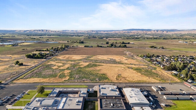
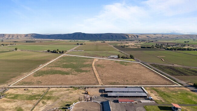
This Property Is For Sale
NEARBY LISTINGS FOR SALE OR LEASE
-
-
View all Toppenish listings for sale on LoopNet.com
Property Detail
Division St S
201010-34001
SECTION 10 TOWNSHIP 10 RANGE 20 QUARTER SW: TH PT OF NE1/4 SW1/4 LY NLY OF NLY R/W LN SSH 22 (3-A) EX CO RD AL WLY LN
Agriculturalland
Yakima
ARE
Washington
53077C1831D
36.35 AC
2025
Outlying Yakima County
2025
Yakima
940005
Yakima, WA
9,756 SF
DEMOGRAPHICS near Division St S
1 Mile
3 Mile
5 Mile
2024 Total Population
5,079
10,731
17,344
2029 Population
5,020
10,555
16,887
Pop Growth 2024-2029
(1.16%)
(1.64%)
(2.63%)
Average Age
33
33
34
2024 Total Households
1,360
2,883
4,960
HH Growth 2024-2029
(1.40%)
(1.94%)
(2.92%)
Median Household Inc
$62,795
$58,682
$62,080
Avg Household Size
3.60
3.60
3.40
2024 Avg HH Vehicles
3.00
3.00
2.00
Median Home Value
$163,445
$174,721
$222,577
Median Year Built
1962
1964
1969
Nearby Places
Map Layers
Map Styles
 Street
 Aerial
- Restaurants
- Banks
- Shops
- Fitness
- Groceries
PUBLIC TRANSPORTATION
AIRPORT
Yakima Air Trml/McAllister Field
DRIVE
WALK
Distance
Yakima Air Trml/McAllister Field
31 min
21.8 mi
Freight Ports
Port of Tacoma
DRIVE
WALK
Distance
Port of Tacoma
206 min
176.0 mi
Nearby Properties
Address
Land Use
TOTAL SIZE
Lot Size
Zoning
Address
Land Use
TOTAL SIZE
Lot Size
Zoning
184,462 SF
38.17 AC
PUB
Address
Land Use
TOTAL SIZE
Lot Size
Zoning
54,446 SF
26.09 AC
PUB
Address
Land Use
TOTAL SIZE
Lot Size
Zoning
67,287 SF
5.17 AC
B2
Address
Land Use
TOTAL SIZE
Lot Size
Zoning
278,569 SF
75.58 AC
M1
Address
Land Use
TOTAL SIZE
Lot Size
Zoning
3.66 AC
PUB
Address
Land Use
TOTAL SIZE
Lot Size
Zoning
80,603 SF
28.65 AC
PUB
Address
Land Use
TOTAL SIZE
Lot Size
Zoning
226,202 SF
8.93 AC
M2
Address
Land Use
TOTAL SIZE
Lot Size
Zoning
115,209 SF
2.52 AC
PUB
Address
Land Use
TOTAL SIZE
Lot Size
Zoning
278,532 SF
21.25 AC
M2
Address
Land Use
TOTAL SIZE
Lot Size
Zoning
71,077 SF
3.77 AC
PUB
Address
Land Use
TOTAL SIZE
Lot Size
Zoning
22,980 SF
1.83 AC
B1
Address
Land Use
TOTAL SIZE
Lot Size
Zoning
36,868 SF
1.94 AC
B2
Address
Land Use
TOTAL SIZE
Lot Size
Zoning
68,523 SF
39.53 AC
AG
Address
Land Use
TOTAL SIZE
Lot Size
Zoning
44,649 SF
4.50 AC
B2
Address
Land Use
TOTAL SIZE
Lot Size
Zoning
43,044 SF
7.67 AC
TRIB
Address
Land Use
TOTAL SIZE
Lot Size
Zoning
209,841 SF
15.78 AC
M2
Address
Land Use
TOTAL SIZE
Lot Size
Zoning
21,187 SF
0.75 AC
B2
Address
Land Use
TOTAL SIZE
Lot Size
Zoning
34,523 SF
17.81 AC
R1
Address
Land Use
TOTAL SIZE
Lot Size
Zoning
19,848 SF
1.34 AC
M1
Address
Land Use
TOTAL SIZE
Lot Size
Zoning
10.83 AC
LIM
Address
Land Use
TOTAL SIZE
Lot Size
Zoning
23,689 SF
1.40 AC
B1
Address
Land Use
TOTAL SIZE
Lot Size
Zoning
20,740 SF
1.55 AC
B2
Address
Land Use
TOTAL SIZE
Lot Size
Zoning
13,056 SF
2.91 AC
B2
Address
Land Use
TOTAL SIZE
Lot Size
Zoning
22,588 SF
11.30 AC
R1
Address
Land Use
TOTAL SIZE
Lot Size
Zoning
19,382 SF
1.97 AC
B1
Address
Land Use
TOTAL SIZE
Lot Size
Zoning
32,925 SF
2.25 AC
PUB
Address
Land Use
TOTAL SIZE
Lot Size
Zoning
33,649 SF
2.04 AC
PUB
Address
Land Use
TOTAL SIZE
Lot Size
Zoning
16,021 SF
1.94 AC
B2
Address
Land Use
TOTAL SIZE
Lot Size
Zoning
28,240 SF
2.41 AC
B1
Address
Land Use
TOTAL SIZE
Lot Size
Zoning
2,748 SF
0.35 AC
B2
The World's #1 Commercial Real Estate Marketplace
Connect with us
© 2026 CoStar Group
The information above has been obtained from sources believed reliable. While we do not doubt its accuracy we have not verified it and make no guarantee, warranty or representation about it. It is your responsibility to independently confirm its accuracy and completeness. Any projections, opinions, assumptions, or estimates used are for example only and do not represent the current or future performance of the property. The value of this transaction to you depends on tax and other factors which should be evaluated by your tax, financial, and legal advisors. You and your advisors should conduct a careful, independent investigation of the property to determine to your satisfaction the suitability of the property for your needs.