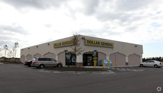
Property Record
35 Murabella Pkwy, Saint Augustine, FL 32092

Property Detail
35 Murabella Pkwy
028670-0024
10-1V ANTONIO HUERTAS GRANT SUB PT OF SUB SEC 10 LYING S OF SR16 & E OF MURABELLA PKWY OR5556/11
Storemultistory
ST. JOHNS
PUD
Florida
B and X Area of moderate flood hazard, usually the area between the limits of the 100-year and 500-year floods.
1.66 AC
2025
St Johns County
2026
Jacksonville (Florida)
020906
Jacksonville, FL
9,232 SF
NEARBY LISTINGS FOR SALE OR LEASE
DEMOGRAPHICS near 35 Murabella Pkwy
1 mile
3 mile
5 mile
2025 Total Population
5,211
28,625
41,251
2030 Population
6,036
33,539
48,494
Pop Growth 2025-2030
+ 15.83%
+ 17.17%
+ 17.56%
Average Age
42
43
42
2025 Total Households
1,838
10,298
14,793
HH Growth 2025-2030
+ 16.43%
+ 18.06%
+ 18.29%
Median Household Inc
$109,027
$111,424
$114,567
Avg Household Size
2.80
2.70
2.70
2025 Avg HH Vehicles
2.00
2.00
2.00
Median Home Value
$483,802
$494,030
$505,117
Median Year Built
2010
2010
2010
Nearby Places
Map Layers
Map Styles
 Street
 Aerial
Transit
 Traffic
 Biking
Places
Listings with unknown addresses are not visible on the map
- Restaurants
- Banks
- Shops
- Fitness
- Groceries
SALE & LEASE HISTORY
LISTING DATE
SALE/LEASE

Oct 26, 2017
For Sale
May 04, 2020
For Sale
Feb 16, 2018
For Sale
Nearby Properties
Address
Land Use
TOTAL SIZE
Lot Size
Zoning
Address
Land Use
TOTAL SIZE
Lot Size
Zoning
38.75 AC
Address
Land Use
TOTAL SIZE
Lot Size
Zoning
223,545 SF
68.79 AC
OR
Address
Land Use
TOTAL SIZE
Lot Size
Zoning
312,893 SF
12.30 AC
Address
Land Use
TOTAL SIZE
Lot Size
Zoning
460,132 SF
26.61 AC
Address
Land Use
TOTAL SIZE
Lot Size
Zoning
252,962 SF
6.86 AC
Address
Land Use
TOTAL SIZE
Lot Size
Zoning
228,680 SF
11.13 AC
Address
Land Use
TOTAL SIZE
Lot Size
Zoning
157,964 SF
66.39 AC
PUD
Address
Land Use
TOTAL SIZE
Lot Size
Zoning
90,363 SF
15.69 AC
PUD
Address
Land Use
TOTAL SIZE
Lot Size
Zoning
159,791 SF
40 AC
PUD
Address
Land Use
TOTAL SIZE
Lot Size
Zoning
99,542 SF
18.10 AC
Address
Land Use
TOTAL SIZE
Lot Size
Zoning
346,647 SF
40.12 AC
PUD
Address
Land Use
TOTAL SIZE
Lot Size
Zoning
50,439 SF
15.50 AC
PUD
Address
Land Use
TOTAL SIZE
Lot Size
Zoning
91,029 SF
15.68 AC
DRI
Address
Land Use
TOTAL SIZE
Lot Size
Zoning
52,896 SF
13.70 AC
Address
Land Use
TOTAL SIZE
Lot Size
Zoning
109,852 SF
12.62 AC
Address
Land Use
TOTAL SIZE
Lot Size
Zoning
151,858 SF
17.24 AC
Address
Land Use
TOTAL SIZE
Lot Size
Zoning
150,535 SF
31.11 AC
OR
Address
Land Use
TOTAL SIZE
Lot Size
Zoning
81,978 SF
2.48 AC
PUD
Address
Land Use
TOTAL SIZE
Lot Size
Zoning
103,847 SF
30.70 AC
PUD
Address
Land Use
TOTAL SIZE
Lot Size
Zoning
106,741 SF
18.50 AC
PUD
Address
Land Use
TOTAL SIZE
Lot Size
Zoning
27.10 AC
Address
Land Use
TOTAL SIZE
Lot Size
Zoning
267,806 SF
2.19 AC
Address
Land Use
TOTAL SIZE
Lot Size
Zoning
107,352 SF
15.88 AC
Address
Land Use
TOTAL SIZE
Lot Size
Zoning
78,878 SF
12.18 AC
PUD
Address
Land Use
TOTAL SIZE
Lot Size
Zoning
42,168 SF
11.07 AC
PUD
Address
Land Use
TOTAL SIZE
Lot Size
Zoning
47,784 SF
9.61 AC
Address
Land Use
TOTAL SIZE
Lot Size
Zoning
9.37 AC
PUD
Address
Land Use
TOTAL SIZE
Lot Size
Zoning
84,211 SF
10.39 AC
DRI
Address
Land Use
TOTAL SIZE
Lot Size
Zoning
67.16 AC
PUD
Address
Land Use
TOTAL SIZE
Lot Size
Zoning
27,037 SF
9 AC
OR
The World's #1 Commercial Real Estate Marketplace
Connect with us
© 2026 CoStar Group
The information above has been obtained from sources believed reliable. While we do not doubt its accuracy we have not verified it and make no guarantee, warranty or representation about it. It is your responsibility to independently confirm its accuracy and completeness. Any projections, opinions, assumptions, or estimates used are for example only and do not represent the current or future performance of the property. The value of this transaction to you depends on tax and other factors which should be evaluated by your tax, financial, and legal advisors. You and your advisors should conduct a careful, independent investigation of the property to determine to your satisfaction the suitability of the property for your needs.