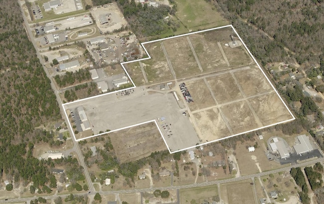
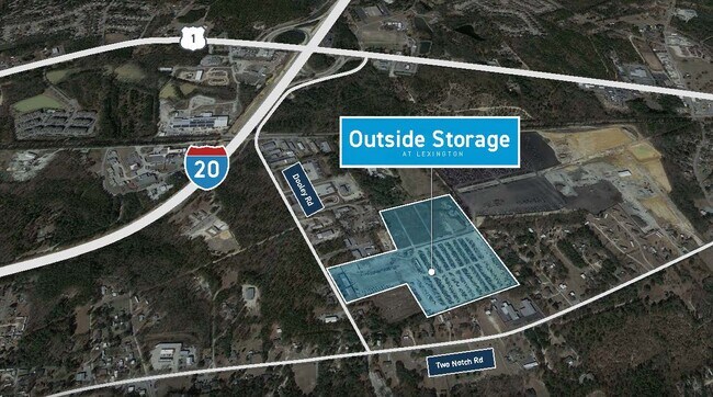
Property Record
Dooley Rd, Lexington, SC 29073
NEARBY LISTINGS FOR SALE OR LEASE
Property Detail
Dooley Rd
005596-02-027
Lexington
Agriculturalland
South Carolina
X
12.82 AC
45063C0252J
Cayce/West Columbia
2025
Columbia
2024
Columbia, SC
021051
DEMOGRAPHICS near Dooley Rd
1 Mile
3 Mile
5 Mile
2024 Total Population
3,448
39,499
85,806
2029 Population
3,726
42,914
93,474
Pop Growth 2024-2029
+ 8.06%
+ 8.65%
+ 8.94%
Average Age
40
39
40
2024 Total Households
1,387
15,810
33,838
HH Growth 2024-2029
+ 8.15%
+ 8.87%
+ 9.14%
Median Household Inc
$69,319
$70,128
$70,345
Avg Household Size
2.40
2.40
2.50
2024 Avg HH Vehicles
2.00
2.00
2.00
Median Home Value
$158,466
$169,591
$188,650
Median Year Built
1998
1994
1995
Nearby Places
Map Layers
Map Styles
 Street
 Aerial
- Restaurants
- Banks
- Shops
- Fitness
- Groceries
PUBLIC TRANSPORTATION
AIRPORT
Columbia Metro
DRIVE
WALK
Distance
Columbia Metro
24 min
6.9 mi
Freight Ports
North Charleston Terminal
DRIVE
WALK
Distance
North Charleston Terminal
125 min
107.9 mi
SALE & LEASE HISTORY
LISTING DATE
SALE/LEASE

Oct 02, 2017
For Sale
Mar 28, 2018
For Lease
Mar 25, 2022
For Lease
Jul 20, 2022
For Lease
Jul 14, 2023
For Lease
Aug 29, 2017
For Lease
Aug 07, 2024
For Lease
Nearby Properties
Address
Land Use
TOTAL SIZE
Lot Size
Zoning
Address
Land Use
TOTAL SIZE
Lot Size
Zoning
78,966 SF
10.34 AC
Address
Land Use
TOTAL SIZE
Lot Size
Zoning
1,485 SF
19.51 AC
GC
Address
Land Use
TOTAL SIZE
Lot Size
Zoning
37,794 SF
22.37 AC
ID
Address
Land Use
TOTAL SIZE
Lot Size
Zoning
4,198 SF
23.54 AC
Address
Land Use
TOTAL SIZE
Lot Size
Zoning
63,658 SF
17.56 AC
GC
Address
Land Use
TOTAL SIZE
Lot Size
Zoning
3,383 SF
20.65 AC
Address
Land Use
TOTAL SIZE
Lot Size
Zoning
38,496 SF
19.41 AC
HDR
Address
Land Use
TOTAL SIZE
Lot Size
Zoning
204,927 SF
24.82 AC
GC
Address
Land Use
TOTAL SIZE
Lot Size
Zoning
78,131 SF
24 AC
GC
Address
Land Use
TOTAL SIZE
Lot Size
Zoning
58.81 AC
RD
Address
Land Use
TOTAL SIZE
Lot Size
Zoning
39,713 SF
11.70 AC
GC
Address
Land Use
TOTAL SIZE
Lot Size
Zoning
86,935 SF
9.91 AC
ID
Address
Land Use
TOTAL SIZE
Lot Size
Zoning
257,688 SF
23.03 AC
ID
Address
Land Use
TOTAL SIZE
Lot Size
Zoning
41,860 SF
6.54 AC
ID
Address
Land Use
TOTAL SIZE
Lot Size
Zoning
64,281 SF
11.71 AC
GC
Address
Land Use
TOTAL SIZE
Lot Size
Zoning
79,246 SF
9.04 AC
GC
Address
Land Use
TOTAL SIZE
Lot Size
Zoning
3,079 SF
15.93 AC
HDR
Address
Land Use
TOTAL SIZE
Lot Size
Zoning
2,065 SF
19.73 AC
HDR
Address
Land Use
TOTAL SIZE
Lot Size
Zoning
85,600 SF
22.08 AC
Address
Land Use
TOTAL SIZE
Lot Size
Zoning
136,940 SF
20.36 AC
GC
Address
Land Use
TOTAL SIZE
Lot Size
Zoning
70,740 SF
13 AC
ID
Address
Land Use
TOTAL SIZE
Lot Size
Zoning
59.61 AC
ID
Address
Land Use
TOTAL SIZE
Lot Size
Zoning
102,553 SF
13.30 AC
GC
Address
Land Use
TOTAL SIZE
Lot Size
Zoning
127,329 SF
10.91 AC
Address
Land Use
TOTAL SIZE
Lot Size
Zoning
85,508 SF
9.22 AC
GC
Address
Land Use
TOTAL SIZE
Lot Size
Zoning
835 SF
6.58 AC
ID
Address
Land Use
TOTAL SIZE
Lot Size
Zoning
62,141 SF
7.28 AC
GC
Address
Land Use
TOTAL SIZE
Lot Size
Zoning
8,269 SF
12.99 AC
RD
Address
Land Use
TOTAL SIZE
Lot Size
Zoning
51,657 SF
3.48 AC
ID
Address
Land Use
TOTAL SIZE
Lot Size
Zoning
10.52 AC
ID
The World's #1 Commercial Real Estate Marketplace
Connect with us
© 2026 CoStar Group
The information above has been obtained from sources believed reliable. While we do not doubt its accuracy we have not verified it and make no guarantee, warranty or representation about it. It is your responsibility to independently confirm its accuracy and completeness. Any projections, opinions, assumptions, or estimates used are for example only and do not represent the current or future performance of the property. The value of this transaction to you depends on tax and other factors which should be evaluated by your tax, financial, and legal advisors. You and your advisors should conduct a careful, independent investigation of the property to determine to your satisfaction the suitability of the property for your needs.