Property Record
Dover Bridge Rd, Preston, MD 21655
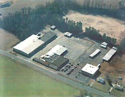
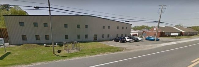
Property Detail
Dover Bridge Rd
Warehouse
3.84 AC W/S PRESTON RD 331 N OF PRESTON
I2
CAROLINE
B and X Area of moderate flood hazard, usually the area between the limits of the 100-year and 500-year floods.
Maryland
2025
3.84 AC
2025
Chesapeake Bay/Salisbury
955500
Other Market Areas
10,000 SF
04-009908
NEARBY LISTINGS FOR SALE OR LEASE
-
-
View all Preston listings for lease on LoopNet.com
DEMOGRAPHICS near Dover Bridge Rd
1 mile
3 mile
5 mile
2025 Total Population
575
2,774
6,118
2030 Population
584
2,825
6,245
Pop Growth 2025-2030
+ 1.57%
+ 1.84%
+ 2.08%
Average Age
42
43
43
2025 Total Households
227
1,088
2,377
HH Growth 2025-2030
+ 1.76%
+ 1.84%
+ 2.06%
Median Household Inc
$70,624
$74,141
$76,524
Avg Household Size
2.50
2.50
2.50
2025 Avg HH Vehicles
2.00
2.00
2.00
Median Home Value
$269,696
$279,220
$282,137
Median Year Built
1969
1974
1978
Nearby Places
Map Layers
Map Styles
 Street
 Aerial
Transit
 Traffic
 Biking
Places
Listings with unknown addresses are not visible on the map
- Restaurants
- Banks
- Shops
- Fitness
- Groceries
SALE & LEASE HISTORY
LISTING DATE
SALE/LEASE

Sep 25, 2016
For Lease
Sep 03, 2019
For Lease
Nearby Properties
Address
Land Use
TOTAL SIZE
Lot Size
Zoning
Address
Land Use
TOTAL SIZE
Lot Size
Zoning
61,782 SF
6 AC
C1 R1
Address
Land Use
TOTAL SIZE
Lot Size
Zoning
3,600 SF
11.30 AC
B-2
Address
Land Use
TOTAL SIZE
Lot Size
Zoning
28,865 SF
6.77 AC
I2
Address
Land Use
TOTAL SIZE
Lot Size
Zoning
16,040 SF
1.22 AC
C2
Address
Land Use
TOTAL SIZE
Lot Size
Zoning
1,872 SF
6.80 AC
I
Address
Land Use
TOTAL SIZE
Lot Size
Zoning
3,290 SF
26.33 AC
B2
Address
Land Use
TOTAL SIZE
Lot Size
Zoning
2,016 SF
111.32 AC
R
Address
Land Use
TOTAL SIZE
Lot Size
Zoning
30,644 SF
13.92 AC
I2
Address
Land Use
TOTAL SIZE
Lot Size
Zoning
22,916 SF
3.95 AC
I
Address
Land Use
TOTAL SIZE
Lot Size
Zoning
55,320 SF
2.40 AC
I
Address
Land Use
TOTAL SIZE
Lot Size
Zoning
3,900 SF
2.52 AC
I
Address
Land Use
TOTAL SIZE
Lot Size
Zoning
7,667 SF
6.30 AC
R
Address
Land Use
TOTAL SIZE
Lot Size
Zoning
3,300 SF
4.13 AC
VC
Address
Land Use
TOTAL SIZE
Lot Size
Zoning
7,572 SF
4.05 AC
R
Address
Land Use
TOTAL SIZE
Lot Size
Zoning
9,432 SF
1.59 AC
VN
Address
Land Use
TOTAL SIZE
Lot Size
Zoning
7,272 SF
0.38 AC
R1
Address
Land Use
TOTAL SIZE
Lot Size
Zoning
154.80 AC
R
Address
Land Use
TOTAL SIZE
Lot Size
Zoning
3,200 SF
0.87 AC
C-1
Address
Land Use
TOTAL SIZE
Lot Size
Zoning
15,245 SF
1.40 AC
C1
Address
Land Use
TOTAL SIZE
Lot Size
Zoning
6,481 SF
0.48 AC
C1
Address
Land Use
TOTAL SIZE
Lot Size
Zoning
2,720 SF
15.41 AC
R2
Address
Land Use
TOTAL SIZE
Lot Size
Zoning
12,000 SF
4.06 AC
C2
Address
Land Use
TOTAL SIZE
Lot Size
Zoning
8.05 AC
MH
Address
Land Use
TOTAL SIZE
Lot Size
Zoning
4,240 SF
0.38 AC
R1
Address
Land Use
TOTAL SIZE
Lot Size
Zoning
4,240 SF
0.30 AC
C1
Address
Land Use
TOTAL SIZE
Lot Size
Zoning
1,740 SF
1.08 AC
I
Address
Land Use
TOTAL SIZE
Lot Size
Zoning
8,836 SF
3.61 AC
I2
Address
Land Use
TOTAL SIZE
Lot Size
Zoning
9,139 SF
9.40 AC
C2
Address
Land Use
TOTAL SIZE
Lot Size
Zoning
1,260 SF
0.26 AC
C1
Address
Land Use
TOTAL SIZE
Lot Size
Zoning
8,720 SF
0.35 AC
R2
The World's #1 Commercial Real Estate Marketplace
Connect with us
© 2026 CoStar Group
The information above has been obtained from sources believed reliable. While we do not doubt its accuracy we have not verified it and make no guarantee, warranty or representation about it. It is your responsibility to independently confirm its accuracy and completeness. Any projections, opinions, assumptions, or estimates used are for example only and do not represent the current or future performance of the property. The value of this transaction to you depends on tax and other factors which should be evaluated by your tax, financial, and legal advisors. You and your advisors should conduct a careful, independent investigation of the property to determine to your satisfaction the suitability of the property for your needs.