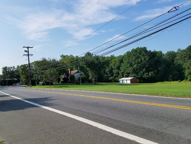
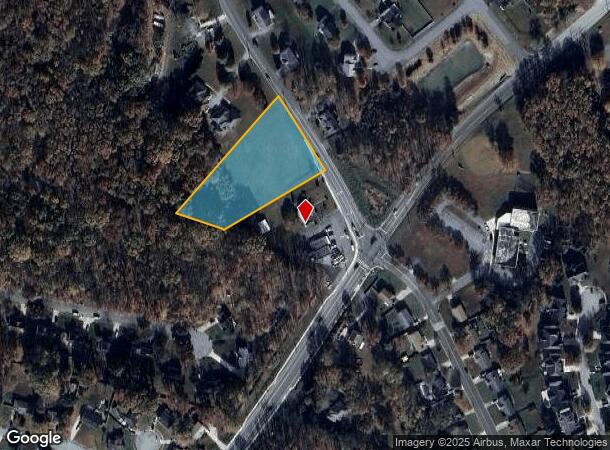
Property Record
6905 Dower House Rd, Upper Marlboro, MD 20772
NEARBY LISTINGS FOR SALE OR LEASE
Property Detail
6905 Dower House Rd
Washington-Arlington-Alexandria, DC-VA-MD-WV
Prince George's
09-0916270
Maryland
Residentialnec
1.88 AC
X
Branch Avenue Corridor
24033C0265E
Washington, DC
1,250 SF
DEMOGRAPHICS near 6905 Dower House Rd
1 Mile
3 Mile
5 Mile
2024 Total Population
5,276
32,136
118,303
2029 Population
5,097
31,652
115,752
Pop Growth 2024-2029
(3.39%)
(1.51%)
(2.16%)
Average Age
43
42
41
2024 Total Households
1,792
11,400
43,560
HH Growth 2024-2029
(3.46%)
(1.56%)
(2.25%)
Median Household Inc
$130,555
$131,539
$109,315
Avg Household Size
2.90
2.70
2.60
2024 Avg HH Vehicles
2.00
2.00
2.00
Median Home Value
$437,523
$440,440
$379,284
Median Year Built
1994
1996
1986
Nearby Places
Map Layers
Map Styles
 Street
 Aerial
- Restaurants
- Banks
- Shops
- Fitness
- Groceries
PUBLIC TRANSPORTATION
AIRPORT
Ronald Reagan Washington Ntl
DRIVE
WALK
Distance
Ronald Reagan Washington Ntl
32 min
17.4 mi
Baltimore/Washington International Thurgood Marshall
DRIVE
WALK
Distance
Baltimore/Washington International Thurgood Marshall
53 min
35.1 mi
Freight Ports
Port of Baltimore
DRIVE
WALK
Distance
Port of Baltimore
63 min
41.6 mi
SALE & LEASE HISTORY
LISTING DATE
SALE/LEASE

Aug 21, 2018
For Sale
Nearby Properties
Address
Land Use
TOTAL SIZE
Lot Size
Zoning
Address
Land Use
TOTAL SIZE
Lot Size
Zoning
203.33 AC
IE
Address
Land Use
TOTAL SIZE
Lot Size
Zoning
98.14 AC
IE
Address
Land Use
TOTAL SIZE
Lot Size
Zoning
117.45 AC
IE
Address
Land Use
TOTAL SIZE
Lot Size
Zoning
223,219 SF
22 AC
CGO
Address
Land Use
TOTAL SIZE
Lot Size
Zoning
124.59 AC
IE
Address
Land Use
TOTAL SIZE
Lot Size
Zoning
111.72 AC
IE
Address
Land Use
TOTAL SIZE
Lot Size
Zoning
117.87 AC
IE
Address
Land Use
TOTAL SIZE
Lot Size
Zoning
269.41 AC
IE
Address
Land Use
TOTAL SIZE
Lot Size
Zoning
157.68 AC
IE
Address
Land Use
TOTAL SIZE
Lot Size
Zoning
138.27 AC
IE
Address
Land Use
TOTAL SIZE
Lot Size
Zoning
358,700 SF
12.24 AC
TACE
Address
Land Use
TOTAL SIZE
Lot Size
Zoning
250.35 AC
IE
Address
Land Use
TOTAL SIZE
Lot Size
Zoning
207,504 SF
8.84 AC
I1
Address
Land Use
TOTAL SIZE
Lot Size
Zoning
116,550 SF
15.60 AC
IE
Address
Land Use
TOTAL SIZE
Lot Size
Zoning
102 AC
IE
Address
Land Use
TOTAL SIZE
Lot Size
Zoning
160,870 SF
3.75 AC
RMF48
Address
Land Use
TOTAL SIZE
Lot Size
Zoning
55,724 SF
10.09 AC
IE
Address
Land Use
TOTAL SIZE
Lot Size
Zoning
115,500 SF
3.10 AC
IE
Address
Land Use
TOTAL SIZE
Lot Size
Zoning
169.75 AC
IE
Address
Land Use
TOTAL SIZE
Lot Size
Zoning
83.26 AC
IE
Address
Land Use
TOTAL SIZE
Lot Size
Zoning
200.65 AC
IE
Address
Land Use
TOTAL SIZE
Lot Size
Zoning
4.56 AC
CGO
Address
Land Use
TOTAL SIZE
Lot Size
Zoning
55,450 SF
7.76 AC
CGO
Address
Land Use
TOTAL SIZE
Lot Size
Zoning
7.22 AC
RR
Address
Land Use
TOTAL SIZE
Lot Size
Zoning
180.47 AC
IE
Address
Land Use
TOTAL SIZE
Lot Size
Zoning
173.67 AC
IE
Address
Land Use
TOTAL SIZE
Lot Size
Zoning
122.43 AC
IE
Address
Land Use
TOTAL SIZE
Lot Size
Zoning
122.63 AC
IE
Address
Land Use
TOTAL SIZE
Lot Size
Zoning
48.97 AC
IE
Address
Land Use
TOTAL SIZE
Lot Size
Zoning
55.65 AC
IE
The World's #1 Commercial Real Estate Marketplace
Connect with us
© 2026 CoStar Group
The information above has been obtained from sources believed reliable. While we do not doubt its accuracy we have not verified it and make no guarantee, warranty or representation about it. It is your responsibility to independently confirm its accuracy and completeness. Any projections, opinions, assumptions, or estimates used are for example only and do not represent the current or future performance of the property. The value of this transaction to you depends on tax and other factors which should be evaluated by your tax, financial, and legal advisors. You and your advisors should conduct a careful, independent investigation of the property to determine to your satisfaction the suitability of the property for your needs.