Property Record
Drake Rd, Strongsville, OH 44136
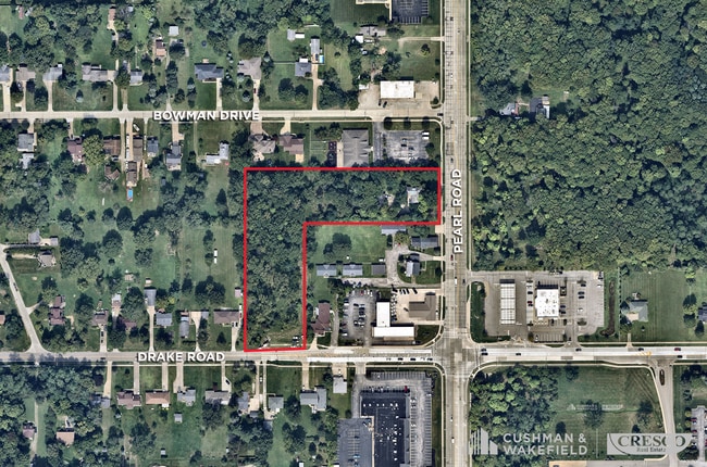


Property Detail
Drake Rd
Cleveland-Elyria, OH
FF 200.00 D 515.00 2.3642 OL 58 S/L 12/16 PT ADD TO ROAD 2010S/R
393-37-010
CUYAHOGA
Residentialacreage
Ohio
R1-75
1216
B and X Area of moderate flood hazard, usually the area between the limits of the 100-year and 500-year floods.
2.37 AC
2025
Southwest
2025
Cleveland
186201
NEARBY LISTINGS FOR SALE OR LEASE
DEMOGRAPHICS near Drake Rd
1 mile
3 mile
5 mile
2025 Total Population
9,350
48,571
119,882
2030 Population
9,169
48,094
119,643
Pop Growth 2025-2030
(1.94%)
(0.98%)
(0.20%)
Average Age
43
44
43
2025 Total Households
3,436
18,909
49,046
HH Growth 2025-2030
(2.12%)
(1.04%)
(0.30%)
Median Household Inc
$115,641
$100,461
$90,559
Avg Household Size
2.60
2.50
2.40
2025 Avg HH Vehicles
2.00
2.00
2.00
Median Home Value
$331,235
$285,735
$275,537
Median Year Built
1986
1980
1980
Nearby Places
Map Layers
Map Styles
 Street
 Aerial
Layers
 Traffic
 Biking
Places
Listings with unknown addresses are not visible on the map
- Restaurants
- Banks
- Shops
- Fitness
- Groceries
PUBLIC TRANSPORTATION
AIRPORT
Cleveland-Hopkins International
Drive
Walk
Distance
Cleveland-Hopkins International
24 min
13.4 mi
Freight Ports
Port of Toledo
Drive
Walk
Distance
Port of Toledo
130 min
106.3 mi
SALE & LEASE HISTORY
LISTING DATE
SALE/LEASE

Mar 06, 2023
For Sale
Nearby Properties
Address
Land Use
TOTAL SIZE
Lot Size
Zoning
Address
Land Use
TOTAL SIZE
Lot Size
Zoning
127,666 SF
2.79 AC
Address
Land Use
TOTAL SIZE
Lot Size
Zoning
830,541 SF
51.19 AC
SC
Address
Land Use
TOTAL SIZE
Lot Size
Zoning
184,998 SF
20.43 AC
PF
Address
Land Use
TOTAL SIZE
Lot Size
Zoning
345,524 SF
107.02 AC
PF
Address
Land Use
TOTAL SIZE
Lot Size
Zoning
62,681 SF
5.48 AC
OB
Address
Land Use
TOTAL SIZE
Lot Size
Zoning
127,666 SF
9.53 AC
Address
Land Use
TOTAL SIZE
Lot Size
Zoning
310,080 SF
28.30 AC
GI
Address
Land Use
TOTAL SIZE
Lot Size
Zoning
143,074 SF
25.34 AC
PDA-2
Address
Land Use
TOTAL SIZE
Lot Size
Zoning
437,700 SF
36.09 AC
GI
Address
Land Use
TOTAL SIZE
Lot Size
Zoning
53,653 SF
30.83 AC
Address
Land Use
TOTAL SIZE
Lot Size
Zoning
288,114 SF
27.52 AC
GB
Address
Land Use
TOTAL SIZE
Lot Size
Zoning
230,291 SF
17.35 AC
Address
Land Use
TOTAL SIZE
Lot Size
Zoning
124,195 SF
54.96 AC
PF
Address
Land Use
TOTAL SIZE
Lot Size
Zoning
381,528 SF
42.50 AC
GI
Address
Land Use
TOTAL SIZE
Lot Size
Zoning
34,005 SF
514.86 AC
PF
Address
Land Use
TOTAL SIZE
Lot Size
Zoning
180,606 SF
10.99 AC
Address
Land Use
TOTAL SIZE
Lot Size
Zoning
149,184 SF
14.09 AC
PDA-2
Address
Land Use
TOTAL SIZE
Lot Size
Zoning
185,284 SF
10.84 AC
Address
Land Use
TOTAL SIZE
Lot Size
Zoning
24.22 AC
PF
Address
Land Use
TOTAL SIZE
Lot Size
Zoning
183,240 SF
15.80 AC
SC
Address
Land Use
TOTAL SIZE
Lot Size
Zoning
6,741 SF
14.90 AC
Address
Land Use
TOTAL SIZE
Lot Size
Zoning
354,820 SF
10.01 AC
RMF-1
Address
Land Use
TOTAL SIZE
Lot Size
Zoning
195.95 AC
PF
Address
Land Use
TOTAL SIZE
Lot Size
Zoning
62,070 SF
18.43 AC
GB
Address
Land Use
TOTAL SIZE
Lot Size
Zoning
95,159 SF
10.97 AC
PF
Address
Land Use
TOTAL SIZE
Lot Size
Zoning
191.03 AC
PF
Address
Land Use
TOTAL SIZE
Lot Size
Zoning
119,880 SF
11.61 AC
GI
Address
Land Use
TOTAL SIZE
Lot Size
Zoning
247,299 SF
23.38 AC
GI
Address
Land Use
TOTAL SIZE
Lot Size
Zoning
271,272 SF
25.13 AC
GI
Address
Land Use
TOTAL SIZE
Lot Size
Zoning
175,308 SF
51.03 AC
GI
The World's #1 Commercial Real Estate Marketplace
Connect with us
© 2026 CoStar Group
The information above has been obtained from sources believed reliable. While we do not doubt its accuracy we have not verified it and make no guarantee, warranty or representation about it. It is your responsibility to independently confirm its accuracy and completeness. Any projections, opinions, assumptions, or estimates used are for example only and do not represent the current or future performance of the property. The value of this transaction to you depends on tax and other factors which should be evaluated by your tax, financial, and legal advisors. You and your advisors should conduct a careful, independent investigation of the property to determine to your satisfaction the suitability of the property for your needs.