Property Record
18370 Dry Mill Rd, Leesburg, VA 20175
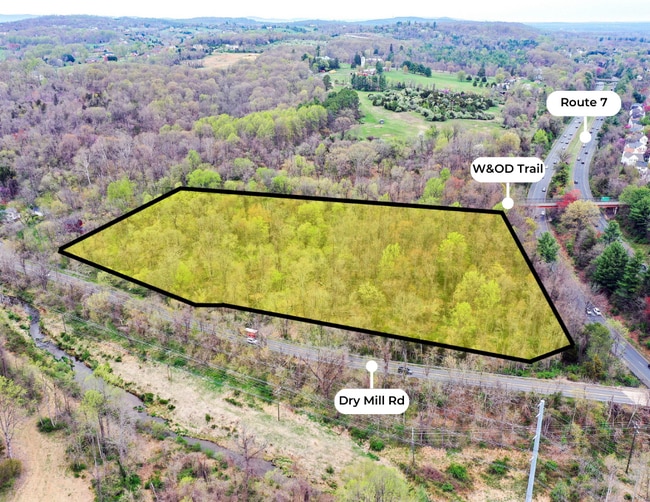


This Property Is For Sale
NEARBY LISTINGS FOR SALE OR LEASE
-
-
View all Leesburg listings for sale on LoopNet.com
Property Detail
18370 Dry Mill Rd
Washington-Arlington-Alexandria, DC-VA-MD-WV
Dry Mill
271-17-2286-001
DRY MILL 200502220019116P 202408260036064 POSE
Vacantlandnec
Loudoun
AE
Virginia
51107C0227E
6.07 AC
2025
Leesburg/West Loudoun
2025
Washington, DC
610703
DEMOGRAPHICS near 18370 Dry Mill Rd
1 Mile
3 Mile
5 Mile
2024 Total Population
5,958
44,142
70,902
2029 Population
6,409
47,600
76,402
Pop Growth 2024-2029
+ 7.57%
+ 7.83%
+ 7.76%
Average Age
41
38
38
2024 Total Households
2,262
14,860
23,250
HH Growth 2024-2029
+ 7.69%
+ 7.79%
+ 7.85%
Median Household Inc
$129,064
$120,844
$139,890
Avg Household Size
2.60
2.90
3.00
2024 Avg HH Vehicles
2.00
2.00
2.00
Median Home Value
$583,810
$607,215
$664,893
Median Year Built
1980
1990
1994
Nearby Places
Map Layers
Map Styles
 Street
 Aerial
- Restaurants
- Banks
- Shops
- Fitness
- Groceries
PUBLIC TRANSPORTATION
AIRPORT
Washington Dulles International
DRIVE
WALK
Distance
Washington Dulles International
29 min
17.6 mi
Freight Ports
Port of Baltimore
DRIVE
WALK
Distance
Port of Baltimore
102 min
74.6 mi
Nearby Properties
Address
Land Use
TOTAL SIZE
Lot Size
Zoning
Address
Land Use
TOTAL SIZE
Lot Size
Zoning
413,297 SF
21.77 AC
LB:MC
Address
Land Use
TOTAL SIZE
Lot Size
Zoning
485,476 SF
54.14 AC
LB:B3
Address
Land Use
TOTAL SIZE
Lot Size
Zoning
300,570 SF
OP
Address
Land Use
TOTAL SIZE
Lot Size
Zoning
331,227 SF
21.75 AC
LB:PRN
Address
Land Use
TOTAL SIZE
Lot Size
Zoning
279,428 SF
132.70 AC
LB:RE
Address
Land Use
TOTAL SIZE
Lot Size
Zoning
248,513 SF
15.77 AC
LB:R22
Address
Land Use
TOTAL SIZE
Lot Size
Zoning
388,150 SF
PDIP
Address
Land Use
TOTAL SIZE
Lot Size
Zoning
261,445 SF
17.95 AC
LB:I1
Address
Land Use
TOTAL SIZE
Lot Size
Zoning
242,603 SF
67.48 AC
LB:RE
Address
Land Use
TOTAL SIZE
Lot Size
Zoning
245,886 SF
52.32 AC
LB:RE
Address
Land Use
TOTAL SIZE
Lot Size
Zoning
158,560 SF
2.44 AC
LB:GC
Address
Land Use
TOTAL SIZE
Lot Size
Zoning
258,867 SF
12.57 AC
LB:R22
Address
Land Use
TOTAL SIZE
Lot Size
Zoning
131,283 SF
27.84 AC
LB:B3
Address
Land Use
TOTAL SIZE
Lot Size
Zoning
148,448 SF
9.71 AC
LB:PEC
Address
Land Use
TOTAL SIZE
Lot Size
Zoning
190,454 SF
31.50 AC
LB:R4
Address
Land Use
TOTAL SIZE
Lot Size
Zoning
83,169 SF
138.05 AC
LB:R1
Address
Land Use
TOTAL SIZE
Lot Size
Zoning
196,665 SF
18.96 AC
LB:PRN
Address
Land Use
TOTAL SIZE
Lot Size
Zoning
72,408 SF
197.99 AC
AR1
Address
Land Use
TOTAL SIZE
Lot Size
Zoning
92,412 SF
18.27 AC
LB:I1
Address
Land Use
TOTAL SIZE
Lot Size
Zoning
79,388 SF
1.86 AC
LB:GC
Address
Land Use
TOTAL SIZE
Lot Size
Zoning
201,306 SF
9.94 AC
LB:R22
Address
Land Use
TOTAL SIZE
Lot Size
Zoning
166,309 SF
3.28 AC
LB:GC
Address
Land Use
TOTAL SIZE
Lot Size
Zoning
50,767 SF
21.86 AC
LB:R6
Address
Land Use
TOTAL SIZE
Lot Size
Zoning
133,110 SF
6.12 AC
LB:R22
Address
Land Use
TOTAL SIZE
Lot Size
Zoning
21,909 SF
61.18 AC
LB:MA
Address
Land Use
TOTAL SIZE
Lot Size
Zoning
61,310 SF
4.90 AC
LB:MC
Address
Land Use
TOTAL SIZE
Lot Size
Zoning
165,825 SF
11.26 AC
LB:R22
Address
Land Use
TOTAL SIZE
Lot Size
Zoning
165,514 SF
30 AC
LB:R1
Address
Land Use
TOTAL SIZE
Lot Size
Zoning
232,886 SF
PDIP
Address
Land Use
TOTAL SIZE
Lot Size
Zoning
93,858 SF
10 AC
LB:R4
The World's #1 Commercial Real Estate Marketplace
Connect with us
© 2025 CoStar Group
The information above has been obtained from sources believed reliable. While we do not doubt its accuracy we have not verified it and make no guarantee, warranty or representation about it. It is your responsibility to independently confirm its accuracy and completeness. Any projections, opinions, assumptions, or estimates used are for example only and do not represent the current or future performance of the property. The value of this transaction to you depends on tax and other factors which should be evaluated by your tax, financial, and legal advisors. You and your advisors should conduct a careful, independent investigation of the property to determine to your satisfaction the suitability of the property for your needs.