Property Record
Dunbar Rd, Warner Robins, GA 31093
This Property Is For Sale
NEARBY LISTINGS FOR SALE OR LEASE
Property Detail
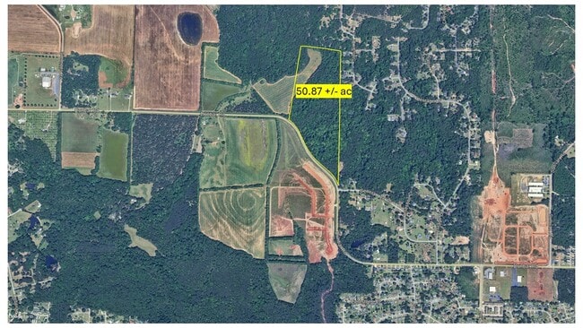
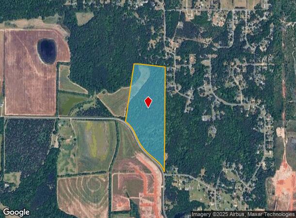
Dunbar Rd
71-84
50.87 ACRES LL 126 127 5 LD
Privatepreserveopenspacevacantlandforestlandconservation
Houston
X
Georgia
13021C0245G
50.87 AC
2024
Perry/Warner Robins
2024
Other Market Areas
020111
Warner Robins, GA
DEMOGRAPHICS near Dunbar Rd
1 Mile
3 Mile
5 Mile
2024 Total Population
1,165
29,745
77,263
2029 Population
1,215
31,373
81,177
Pop Growth 2024-2029
+ 4.29%
+ 5.47%
+ 5.07%
Average Age
44
40
39
2024 Total Households
451
11,911
30,880
HH Growth 2024-2029
+ 4.21%
+ 5.43%
+ 5.10%
Median Household Inc
$76,712
$61,684
$62,104
Avg Household Size
2.50
2.50
2.40
2024 Avg HH Vehicles
3.00
2.00
2.00
Median Home Value
$170,999
$167,382
$167,708
Median Year Built
1985
1986
1984
Nearby Places
Map Layers
Map Styles
 Street
 Aerial
- Restaurants
- Banks
- Shops
- Fitness
- Groceries
Nearby Properties
Address
Land Use
TOTAL SIZE
Lot Size
Zoning
Address
Land Use
TOTAL SIZE
Lot Size
Zoning
17,952 SF
1,075.78 AC
M-1
Address
Land Use
TOTAL SIZE
Lot Size
Zoning
780,000 SF
70.50 AC
M-2
Address
Land Use
TOTAL SIZE
Lot Size
Zoning
11,088 SF
59.57 AC
M-2
Address
Land Use
TOTAL SIZE
Lot Size
Zoning
226,032 SF
49.90 AC
C2
Address
Land Use
TOTAL SIZE
Lot Size
Zoning
11,056 SF
17.41 AC
R4
Address
Land Use
TOTAL SIZE
Lot Size
Zoning
92,930 SF
18.66 AC
C2
Address
Land Use
TOTAL SIZE
Lot Size
Zoning
158,300 SF
29.99 AC
R1
Address
Land Use
TOTAL SIZE
Lot Size
Zoning
223,608 SF
22.40 AC
C2
Address
Land Use
TOTAL SIZE
Lot Size
Zoning
6,336 SF
27.16 AC
R4
Address
Land Use
TOTAL SIZE
Lot Size
Zoning
194,390 SF
242 AC
A
Address
Land Use
TOTAL SIZE
Lot Size
Zoning
128,540 SF
32.26 AC
R2
Address
Land Use
TOTAL SIZE
Lot Size
Zoning
132,851 SF
24.05 AC
C2
Address
Land Use
TOTAL SIZE
Lot Size
Zoning
90,000 SF
12 AC
R1
Address
Land Use
TOTAL SIZE
Lot Size
Zoning
61,628 SF
45 AC
C2
Address
Land Use
TOTAL SIZE
Lot Size
Zoning
100,000 SF
32.51 AC
M-2
Address
Land Use
TOTAL SIZE
Lot Size
Zoning
5,400 SF
16.21 AC
R4
Address
Land Use
TOTAL SIZE
Lot Size
Zoning
108,500 SF
10.85 AC
C2
Address
Land Use
TOTAL SIZE
Lot Size
Zoning
4,720 SF
12.53 AC
C2
Address
Land Use
TOTAL SIZE
Lot Size
Zoning
108,075 SF
10.55 AC
R2
Address
Land Use
TOTAL SIZE
Lot Size
Zoning
113,895 SF
10 AC
M-1
Address
Land Use
TOTAL SIZE
Lot Size
Zoning
44,400 SF
8.28 AC
C2
Address
Land Use
TOTAL SIZE
Lot Size
Zoning
4,720 SF
8.66 AC
C2
Address
Land Use
TOTAL SIZE
Lot Size
Zoning
2,880 SF
16.49 AC
PUD
Address
Land Use
TOTAL SIZE
Lot Size
Zoning
3,200 SF
17.67 AC
R2
Address
Land Use
TOTAL SIZE
Lot Size
Zoning
102,163 SF
10.02 AC
M-1
Address
Land Use
TOTAL SIZE
Lot Size
Zoning
19,613 SF
5.85 AC
C2
Address
Land Use
TOTAL SIZE
Lot Size
Zoning
3,139 SF
10.85 AC
R4
Address
Land Use
TOTAL SIZE
Lot Size
Zoning
35,940 SF
18.96 AC
C2
Address
Land Use
TOTAL SIZE
Lot Size
Zoning
71,152 SF
3.35 AC
C2
Address
Land Use
TOTAL SIZE
Lot Size
Zoning
2,583 SF
15.25 AC
R4
The World's #1 Commercial Real Estate Marketplace
Connect with us
© 2026 CoStar Group
The information above has been obtained from sources believed reliable. While we do not doubt its accuracy we have not verified it and make no guarantee, warranty or representation about it. It is your responsibility to independently confirm its accuracy and completeness. Any projections, opinions, assumptions, or estimates used are for example only and do not represent the current or future performance of the property. The value of this transaction to you depends on tax and other factors which should be evaluated by your tax, financial, and legal advisors. You and your advisors should conduct a careful, independent investigation of the property to determine to your satisfaction the suitability of the property for your needs.