Property Record
Kilcrease Rd, Auburn, GA 30011

This Property Is For Sale
NEARBY LISTINGS FOR SALE OR LEASE
Property Detail
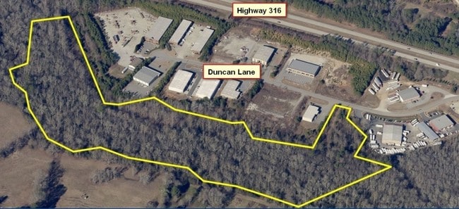
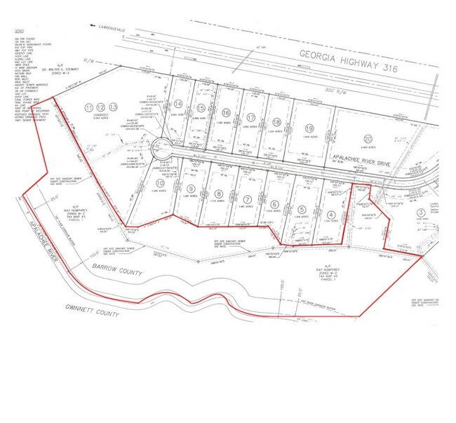
Kilcrease Rd
Atlanta-Sandy Springs-Roswell, GA
Mulberry Woods Unit Three
XX043-001
KILCREASE RD
Industrialacreage
Barrow
AE
Georgia
13135C0078G
res
2025
18 AC
2025
Barrow County
180106
Atlanta
DEMOGRAPHICS near Kilcrease Rd
1 Mile
3 Mile
5 Mile
2024 Total Population
831
18,402
59,721
2029 Population
925
20,330
66,492
Pop Growth 2024-2029
+ 11.31%
+ 10.48%
+ 11.34%
Average Age
37
36
36
2024 Total Households
280
5,859
18,723
HH Growth 2024-2029
+ 11.79%
+ 10.92%
+ 11.78%
Median Household Inc
$79,878
$82,867
$80,974
Avg Household Size
2.90
3.10
3.10
2024 Avg HH Vehicles
2.00
2.00
2.00
Median Home Value
$236,232
$260,362
$254,279
Median Year Built
1995
2001
2001
Nearby Places
Map Layers
Map Styles
 Street
 Aerial
- Restaurants
- Banks
- Shops
- Fitness
- Groceries
Nearby Properties
Address
Land Use
TOTAL SIZE
Lot Size
Zoning
Address
Land Use
TOTAL SIZE
Lot Size
Zoning
10,128 SF
28.19 AC
R-3
Address
Land Use
TOTAL SIZE
Lot Size
Zoning
420,876 SF
26.84 AC
M-2
Address
Land Use
TOTAL SIZE
Lot Size
Zoning
164,877 SF
34.89 AC
C1
Address
Land Use
TOTAL SIZE
Lot Size
Zoning
120,000 SF
142.73 AC
AG
Address
Land Use
TOTAL SIZE
Lot Size
Zoning
305,327 SF
22.05 AC
M-2
Address
Land Use
TOTAL SIZE
Lot Size
Zoning
301,200 SF
39.18 AC
M-2
Address
Land Use
TOTAL SIZE
Lot Size
Zoning
47,141 SF
8.29 AC
AG
Address
Land Use
TOTAL SIZE
Lot Size
Zoning
231,285 SF
34.50 AC
M-2
Address
Land Use
TOTAL SIZE
Lot Size
Zoning
167,580 SF
21.82 AC
M-2
Address
Land Use
TOTAL SIZE
Lot Size
Zoning
183,060 SF
17.90 AC
M-2
Address
Land Use
TOTAL SIZE
Lot Size
Zoning
89,520 SF
13.99 AC
M-2
Address
Land Use
TOTAL SIZE
Lot Size
Zoning
23,546 SF
24.55 AC
RA200
Address
Land Use
TOTAL SIZE
Lot Size
Zoning
64,800 SF
47.27 AC
M-1
Address
Land Use
TOTAL SIZE
Lot Size
Zoning
20,660 SF
10.94 AC
RA200
Address
Land Use
TOTAL SIZE
Lot Size
Zoning
38,550 SF
3.04 AC
C-2
Address
Land Use
TOTAL SIZE
Lot Size
Zoning
26,616 SF
0.66 AC
Address
Land Use
TOTAL SIZE
Lot Size
Zoning
15,808 SF
16.43 AC
RA200
Address
Land Use
TOTAL SIZE
Lot Size
Zoning
16,384 SF
5.10 AC
RA200
Address
Land Use
TOTAL SIZE
Lot Size
Zoning
20,132 SF
1.21 AC
CBD
Address
Land Use
TOTAL SIZE
Lot Size
Zoning
212.21 AC
RA200
Address
Land Use
TOTAL SIZE
Lot Size
Zoning
151.81 AC
Address
Land Use
TOTAL SIZE
Lot Size
Zoning
1,036 SF
120.72 AC
C1
Address
Land Use
TOTAL SIZE
Lot Size
Zoning
65,500 SF
10.50 AC
DOWNTOWN O
Address
Land Use
TOTAL SIZE
Lot Size
Zoning
105.46 AC
Address
Land Use
TOTAL SIZE
Lot Size
Zoning
166.81 AC
RA200
Address
Land Use
TOTAL SIZE
Lot Size
Zoning
95.60 AC
RA200
Address
Land Use
TOTAL SIZE
Lot Size
Zoning
5,198 SF
8 AC
RA200
Address
Land Use
TOTAL SIZE
Lot Size
Zoning
2,455 SF
14.74 AC
RM8
Address
Land Use
TOTAL SIZE
Lot Size
Zoning
49,527 SF
19.22 AC
M-2
Address
Land Use
TOTAL SIZE
Lot Size
Zoning
51,896 SF
6.23 AC
M-1
The World's #1 Commercial Real Estate Marketplace
Connect with us
© 2026 CoStar Group
The information above has been obtained from sources believed reliable. While we do not doubt its accuracy we have not verified it and make no guarantee, warranty or representation about it. It is your responsibility to independently confirm its accuracy and completeness. Any projections, opinions, assumptions, or estimates used are for example only and do not represent the current or future performance of the property. The value of this transaction to you depends on tax and other factors which should be evaluated by your tax, financial, and legal advisors. You and your advisors should conduct a careful, independent investigation of the property to determine to your satisfaction the suitability of the property for your needs.