Property Record
Dundee Azalia Rd, Dundee, MI 48131
NEARBY LISTINGS FOR SALE OR LEASE
Property Detail
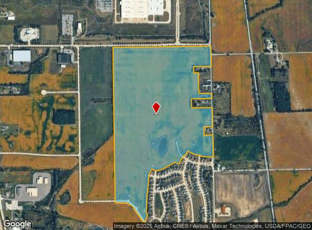
Dundee Azalia Rd
Monroe, MI
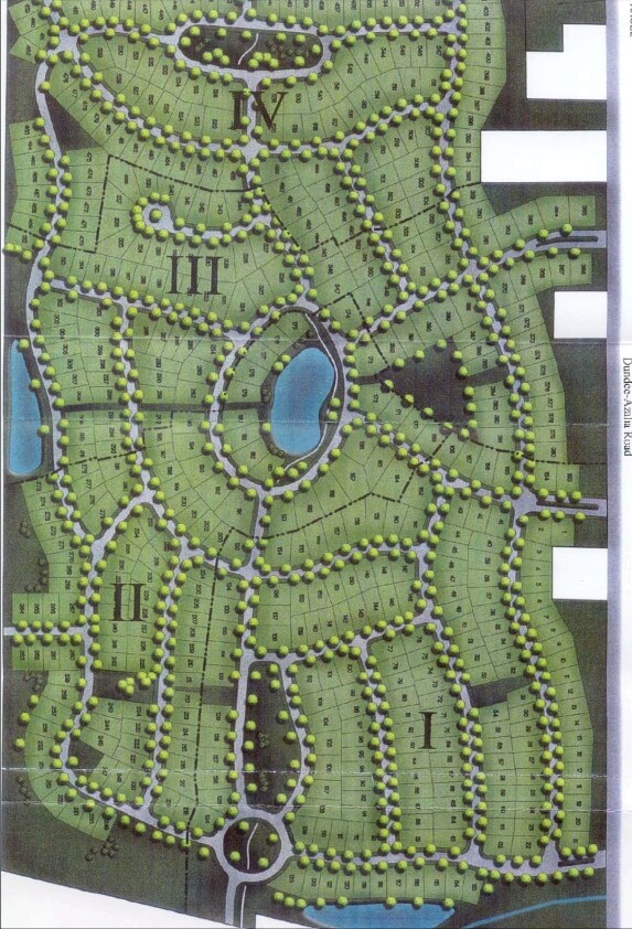
Arbor Chase Condominium
42-013-002-01
PER SURVEY SEC 12 T6S R6 146.81 AC COM AT SE COR OF SEC 12 TH N 89 DEG 38'19"W 439.26 FT ALG S LI OF SEC 12 TO CL OF
Residentialacreage
Monroe
A
Michigan
26115C0183E
146.81 AC
2025
Monroe County
2025
Detroit
830801
DEMOGRAPHICS near Dundee Azalia Rd
1 Mile
3 Mile
5 Mile
2024 Total Population
3,275
7,586
11,113
2029 Population
3,382
7,796
11,311
Pop Growth 2024-2029
+ 3.27%
+ 2.77%
+ 1.78%
Average Age
37
38
40
2024 Total Households
1,345
3,082
4,403
HH Growth 2024-2029
+ 3.35%
+ 2.92%
+ 1.91%
Median Household Inc
$69,999
$70,421
$73,530
Avg Household Size
2.40
2.40
2.50
2024 Avg HH Vehicles
2.00
2.00
2.00
Median Home Value
$224,102
$239,268
$243,126
Median Year Built
1994
1993
1978
Nearby Places
Map Layers
Map Styles
 Street
 Aerial
- Restaurants
- Banks
- Shops
- Fitness
- Groceries
PUBLIC TRANSPORTATION
AIRPORT
Eugene F Kranz Toledo Express
DRIVE
WALK
Distance
Eugene F Kranz Toledo Express
56 min
37.2 mi
Detroit Metro Wayne County
DRIVE
WALK
Distance
Detroit Metro Wayne County
50 min
40.2 mi
Freight Ports
Port of Toledo
DRIVE
WALK
Distance
Port of Toledo
54 min
36.4 mi
Nearby Properties
Address
Land Use
TOTAL SIZE
Lot Size
Zoning
Address
Land Use
TOTAL SIZE
Lot Size
Zoning
676,189 SF
148.70 AC
Address
Land Use
TOTAL SIZE
Lot Size
Zoning
87.22 AC
Address
Land Use
TOTAL SIZE
Lot Size
Zoning
617,380 SF
93.35 AC
Address
Land Use
TOTAL SIZE
Lot Size
Zoning
137,259 SF
9.20 AC
Address
Land Use
TOTAL SIZE
Lot Size
Zoning
150,569 SF
11.16 AC
Address
Land Use
TOTAL SIZE
Lot Size
Zoning
60,934 SF
2.60 AC
Address
Land Use
TOTAL SIZE
Lot Size
Zoning
Address
Land Use
TOTAL SIZE
Lot Size
Zoning
Address
Land Use
TOTAL SIZE
Lot Size
Zoning
100,070 SF
6.77 AC
Address
Land Use
TOTAL SIZE
Lot Size
Zoning
135,300 SF
9.25 AC
Address
Land Use
TOTAL SIZE
Lot Size
Zoning
90,136 SF
3.60 AC
Address
Land Use
TOTAL SIZE
Lot Size
Zoning
95,940 SF
9.57 AC
Address
Land Use
TOTAL SIZE
Lot Size
Zoning
30,520 SF
5 AC
Address
Land Use
TOTAL SIZE
Lot Size
Zoning
48,280 SF
8.40 AC
Address
Land Use
TOTAL SIZE
Lot Size
Zoning
Address
Land Use
TOTAL SIZE
Lot Size
Zoning
16,301 SF
5.83 AC
Address
Land Use
TOTAL SIZE
Lot Size
Zoning
39,814 SF
3.04 AC
Address
Land Use
TOTAL SIZE
Lot Size
Zoning
73,168 SF
21.32 AC
Address
Land Use
TOTAL SIZE
Lot Size
Zoning
74,000 SF
52.40 AC
Address
Land Use
TOTAL SIZE
Lot Size
Zoning
20,504 SF
14.89 AC
Address
Land Use
TOTAL SIZE
Lot Size
Zoning
91,219 SF
9.94 AC
Address
Land Use
TOTAL SIZE
Lot Size
Zoning
31,180 SF
3.39 AC
Address
Land Use
TOTAL SIZE
Lot Size
Zoning
Address
Land Use
TOTAL SIZE
Lot Size
Zoning
46,943 SF
6.29 AC
Address
Land Use
TOTAL SIZE
Lot Size
Zoning
58,734 SF
13.36 AC
Address
Land Use
TOTAL SIZE
Lot Size
Zoning
24,800 SF
2.89 AC
Address
Land Use
TOTAL SIZE
Lot Size
Zoning
48,628 SF
7.95 AC
Address
Land Use
TOTAL SIZE
Lot Size
Zoning
43,869 SF
3.15 AC
Address
Land Use
TOTAL SIZE
Lot Size
Zoning
22,388 SF
4.38 AC
Address
Land Use
TOTAL SIZE
Lot Size
Zoning
43,489 SF
3.61 AC
The World's #1 Commercial Real Estate Marketplace
Connect with us
© 2026 CoStar Group
The information above has been obtained from sources believed reliable. While we do not doubt its accuracy we have not verified it and make no guarantee, warranty or representation about it. It is your responsibility to independently confirm its accuracy and completeness. Any projections, opinions, assumptions, or estimates used are for example only and do not represent the current or future performance of the property. The value of this transaction to you depends on tax and other factors which should be evaluated by your tax, financial, and legal advisors. You and your advisors should conduct a careful, independent investigation of the property to determine to your satisfaction the suitability of the property for your needs.