Property Record
Dunlevie Rd, Allenhurst, GA 31301
Save to a Folder
{{folder.Name}}
{{folder.ListingIds.length}} Properties
{{folder.ListingIds.length}} Property
Create a New Folder
Property Detail
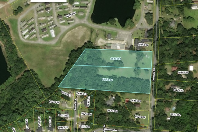
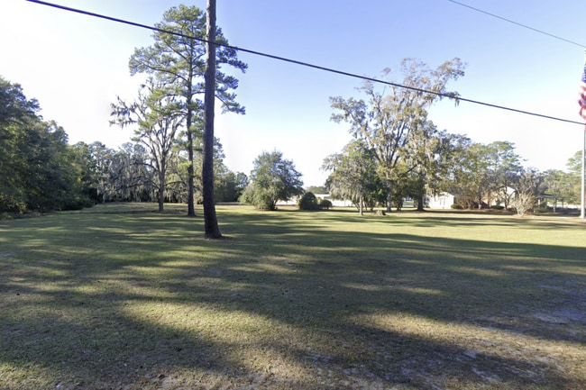
Dunlevie Rd
062C-003
2.60 AC W/S DUNLEVIE RD
Residentialacreage
LIBERTY
R12
Georgia
A Areas with a 1% annual chance of flooding and a 26% chance of flooding over the life of a 30-year mortgage.
2.60 AC
2025
Liberty County
2025
Savannah
010204
Hinesville, GA
NEARBY LISTINGS FOR SALE OR LEASE
DEMOGRAPHICS near Dunlevie Rd
1 mile
3 mile
5 mile
2025 Total Population
1,818
20,395
42,794
2030 Population
1,928
21,917
45,950
Pop Growth 2025-2030
+ 6.05%
+ 7.46%
+ 7.37%
Average Age
35
34
33
2025 Total Households
699
7,424
15,772
HH Growth 2025-2030
+ 6.15%
+ 7.52%
+ 7.39%
Median Household Inc
$64,295
$59,611
$60,101
Avg Household Size
2.60
2.70
2.70
2025 Avg HH Vehicles
2.00
2.00
2.00
Median Home Value
$200,735
$173,093
$186,971
Median Year Built
1992
1992
1992
Nearby Places
Map Layers
Map Styles
 Street
 Aerial
Layers
 Traffic
 Biking
Places
Listings with unknown addresses are not visible on the map
- Restaurants
- Banks
- Shops
- Fitness
- Groceries
Nearby Properties
Address
Land Use
TOTAL SIZE
Lot Size
Zoning
Address
Land Use
TOTAL SIZE
Lot Size
Zoning
3,354 SF
58.90 AC
C3/R20
Address
Land Use
TOTAL SIZE
Lot Size
Zoning
11,944 SF
39.41 AC
LI
Address
Land Use
TOTAL SIZE
Lot Size
Zoning
81,366 SF
16.50 AC
R20
Address
Land Use
TOTAL SIZE
Lot Size
Zoning
71,899 SF
50.12 AC
LI
Address
Land Use
TOTAL SIZE
Lot Size
Zoning
53,103 SF
34.03 AC
I1
Address
Land Use
TOTAL SIZE
Lot Size
Zoning
42,572 SF
5.27 AC
C2
Address
Land Use
TOTAL SIZE
Lot Size
Zoning
21.14 AC
C3/MFR
Address
Land Use
TOTAL SIZE
Lot Size
Zoning
1,236 SF
4.50 AC
C3
Address
Land Use
TOTAL SIZE
Lot Size
Zoning
896 SF
1,579.79 AC
UNZONED RU
Address
Land Use
TOTAL SIZE
Lot Size
Zoning
46,592 SF
10.49 AC
MFR
Address
Land Use
TOTAL SIZE
Lot Size
Zoning
13,500 SF
4.90 AC
LI
Address
Land Use
TOTAL SIZE
Lot Size
Zoning
29,704 SF
3.09 AC
AR1
Address
Land Use
TOTAL SIZE
Lot Size
Zoning
23,314 SF
4.70 AC
C2/C3/R8
Address
Land Use
TOTAL SIZE
Lot Size
Zoning
42,240 SF
4.80 AC
MFR
Address
Land Use
TOTAL SIZE
Lot Size
Zoning
1,520 SF
5.51 AC
C2
Address
Land Use
TOTAL SIZE
Lot Size
Zoning
1,560 SF
3.62 AC
C3
Address
Land Use
TOTAL SIZE
Lot Size
Zoning
12,000 SF
4.14 AC
AR1
Address
Land Use
TOTAL SIZE
Lot Size
Zoning
2,000 SF
69 AC
LI
Address
Land Use
TOTAL SIZE
Lot Size
Zoning
27,129 SF
7.29 AC
LI
Address
Land Use
TOTAL SIZE
Lot Size
Zoning
76.06 AC
LI
Address
Land Use
TOTAL SIZE
Lot Size
Zoning
4,857 SF
1.42 AC
PUD
Address
Land Use
TOTAL SIZE
Lot Size
Zoning
17,218 SF
2.28 AC
MFR
Address
Land Use
TOTAL SIZE
Lot Size
Zoning
5.52 AC
C3
Address
Land Use
TOTAL SIZE
Lot Size
Zoning
3,500 SF
3.36 AC
MFR
Address
Land Use
TOTAL SIZE
Lot Size
Zoning
20,000 SF
37.93 AC
COMMERCIAL
Address
Land Use
TOTAL SIZE
Lot Size
Zoning
8,881 SF
11.57 AC
R20
Address
Land Use
TOTAL SIZE
Lot Size
Zoning
10 AC
C3
Address
Land Use
TOTAL SIZE
Lot Size
Zoning
976 SF
24.23 AC
COMMERCIAL
Address
Land Use
TOTAL SIZE
Lot Size
Zoning
11,544 SF
2.47 AC
MFR
Address
Land Use
TOTAL SIZE
Lot Size
Zoning
4,560 SF
2.58 AC
C3
The World's #1 Commercial Real Estate Marketplace
Connect with us
© 2026 CoStar Group
The information above has been obtained from sources believed reliable. While we do not doubt its accuracy we have not verified it and make no guarantee, warranty or representation about it. It is your responsibility to independently confirm its accuracy and completeness. Any projections, opinions, assumptions, or estimates used are for example only and do not represent the current or future performance of the property. The value of this transaction to you depends on tax and other factors which should be evaluated by your tax, financial, and legal advisors. You and your advisors should conduct a careful, independent investigation of the property to determine to your satisfaction the suitability of the property for your needs.